Gomal River
Gomal River (Urdu: دریائے گومل, Pashto: ګومل سیند، ګومل دریاب, Sanskrit: गोमती) is a 400 km long river in Afghanistan and Pakistan.
| Gomal | |
|---|---|
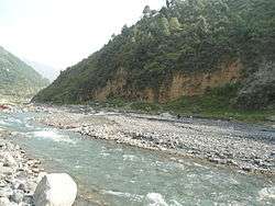 | |
.png) Course of the Gomal | |
| Location | |
| Country | Afghanistan & Pakistan |
| State | Paktika Province, Balochistan, Khyber Pakhtunkhwa |
| Physical characteristics | |
| Source | |
| ⁃ location | Katawaz Region, Gomal District, Paktika Province, Afghanistan |
| ⁃ coordinates | 32.502974°N 68.901294°E |
| Mouth | Indus River |
⁃ location | Dera Ismail Khan, Dera Ismail Khan District, Khyber Pakhtunkhwa, Pakistan |
⁃ coordinates | 31°36′53″N 70°50′46″E |
| Length | 400 km (250 mi) |
| Basin features | |
| Tributaries | |
| ⁃ left | Wana Khwar |
| ⁃ right | Zhob River |
The river was described in Ramayana, as Gomatī River (2.49.11).
The river lends its name to the Gomal University in Dera Ismail Khan and the like-named Gomal District in Paktika Province of Afghanistan.
Course
Gomal River's headwaters are located south-east of Ghazni. The springs which form the headwaters of the Gomal's main branch emerge above the fort at Babakarkol in Katawaz, a district inhabited by Ghilji Pashtuns from the Kharoti and Sulaimankhel clans, in Paktika Province.[1] The Gomal's other branch, the "Second Gomal", joins the main channel about 14 miles below its source.[2] The Gomal flows southeast through eastern Ghilji country before entering Pakistan.[3][4]
Within Pakistan, the Gomal River forms the boundary between Balochistan and the South Waziristan Agency (formerly part of the Federally Administered Tribal Areas, but now part of Khyber Pakhtunkhwa). After approximately 110 miles from its source, it merges with the Zhob River, its major tributary, near Khajuri Kach.[3][4]
It is about 100 miles from the Zhob River to the Indus River. From South Waziristan, the river enters the Gomal Valley in the district of Tank, Pakistan at a place known as Girdavi, Murtuza which is inhabited by the Miani tribe. It is mainly here that the water of Gomal is used to cultivate the lands in Gomal Valley through Zam System (Rod Kohi). The river passes then through the Damaan plain in Kulachi Tehsil and later on through Dera Ismail Khan Tehsil, It then joins the Indus River 20 miles south of Dera Ismail Khan.[4]
Gomal Zam Dam

The daming of this river at Khajuri Kachh was envisaged as back as 1898, even after its administrative approval by the Government of Pakistan in 1963. Work on the Gomal Zam Dam was stopped in 1965; not to restart till 2001 during the rule of Pervez Musharraf.[5] while it was opened in 2013.
There is also a street in E-7, Islamabad called the "Gomal Road".
See also
Notes
- "Natural Geography of Pakistan: 5- Hydrology: 5-1- Rivers: Gomal River"Archived 22 July 2011 at the Wayback Machine ECO Geoscience Database
- MacGregor, Charles Metcalfe (1871) Central Asia, pt. 2: A Contribution Toward the Better Knowledge of the Topography, Ethnology, Resources, and History of Afghanistan Office of the Superintendent of Government Printing, Calcutta, OCLC 48604589 reprinted by Barbican Publishing Co., Petersfield, England, in 1995, p. 308
- MacGregor, pp. 308-9
- Gazetteer of Afghanistan VI (Farah), fourth ed., Calcutta, 1908, p. 238
- The Nation, Lahore, August 28; 2001 and Tareekh i Sarzameen i Gomal ISBN 978-969-37-0270-5; National Book Foundation Islamabad P- 433-34
Further reading
- Hanifi, Shah Mahmoud, "Gōmal", Encyclopaedia Iranica
External links
| Wikisource has the text of the 1911 Encyclopædia Britannica article Gomal. |
- Gomal River marked on the OpenStreetMap
- https://web.archive.org/web/20071026033718/http://www.khyber.org/places/2005/TheGomalRiver.shtml
| Authority control |
|
|---|