Sabarmati River
The Sabarmati river is one of the major west-flowing rivers in India.[3] It originates in the Aravalli Range of the Udaipur District of Rajasthan and meets the Gulf of Khambhat of Arabian Sea after travelling 371 km (231 mi) in a south-westerly direction across Rajasthan and Gujarat.[3] 48 km (30 mi) of the river length is in Rajasthan, while 323 km (201 mi) is in Gujarat.[3]
| Sabarmati River | |
|---|---|
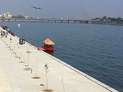 Sabarmati River near Ahmedabad, Gujarat | |
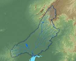 Map of the Sabarmati River watershed | |
| Location | |
| Country | India |
| State | Gujarat, Rajasthan |
| Cities | Ahmedabad, Gandhinagar |
| Physical characteristics | |
| Source | |
| • location | Aravalli Range, Udaipur District, Rajasthan, India |
| • elevation | 782 m (2,566 ft) |
| Mouth | |
• location | Gulf of Khambhat, Gujarat, India |
| Length | 371 km (231 mi)[1] |
| Basin size | 30,680 km2 (11,850 sq mi)[1] |
| Discharge | |
| • average | 120 m3/s (4,200 cu ft/s) |
| Discharge | |
| • location | Ahmedabad[2] |
| • average | 33 m3/s (1,200 cu ft/s) |
| • minimum | 0 m3/s (0 cu ft/s) |
| • maximum | 484 m3/s (17,100 cu ft/s) |
| Basin features | |
| Tributaries | |
| • left | Wakal River, Harnav River, Hathmati River, Watrak River[1] |
| • right | Sei River[1] |
Basin
The catchment area of the Sabarmati basin is 21,674 km2 (8,368 sq mi) out of which 4,124 km2 (1,592 sq mi) lies in Rajasthan State and the remaining 18,550 km2 (7,160 sq mi) in Gujarat.[4] The basin is located in a semi-arid zone with rainfall ranging from 450 to 800 mm (18 to 31 in) in different parts of the basin.[5] The river traverses three geomorphic zones: rocky uplands, middle alluvial plains, and lower estuarine zone.[6]
The major tributaries are the Watrak, Wakal, Hathmati, Harnav, and Sei rivers.[3][4][7] Average annual water availability in the Sabarmati basin is 308 m3 (10,900 cu ft) per capita, which is significantly lower than the national average of 1,545 m3 (54,600 cu ft) per capita.[8]
The Sabarmati is a seasonal river whose flows are dominated by the monsoon, with little or no flows post-monsoon.[5] An average flow of 33 m3 (1,200 cu ft) per second was measured at Ahmedabad during the period 1968-1979.[9] Over the past century, the flood of August 1973 is considered to be the largest flood,[5] when a flow of 14,150 m3 (500,000 cu ft) per second was measured at Dharoi.[10]
History
One of the myths surrounding the origin of the river is that Shiva brought the goddess Ganga to Gujarat and that caused the Sabarmati to come into being.[11]
During India's independence struggle, Mahatma Gandhi established Sabarmati Ashram as his home on the banks of this river.[12]
The National Water Quality Programme led by Central Pollution Control Board (CPCB) positions Sabarmati River as one of the most polluted rivers in India.[13]
Dams
There are several reservoirs on Sabarmati and its tributaries. The Dharoi dam is located on the main river. Hathmati dam, Harnav dam and Guhai dam are located on the tributaries meeting the main river upstream of Ahmedabad while Meshvo reservoir, Meshvo pick-up weir, Mazam dam and Watrak dam are located on tributaries meeting downstream. The Kalpasar is planned project in the Gulf of Khambhat.
Gallery
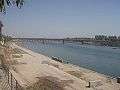 Construction work going on near the river under the Sabarmati River Front Development Project
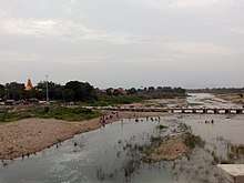
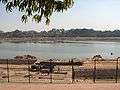 River Sabarmati in Ahmedabad, Gujarat
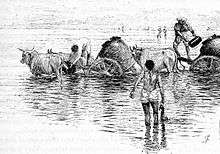
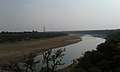 Sabarmati River near Ambod
See also
- Ahmedabad
- List of rivers in India
- Sabarmati Ashram
References
- Sabarmati Basin. Government of India Ministry of Water Resources. 2014. Retrieved 3 May 2019.
- "Sabarmati Basin Station: Ahmedabad". UNH/GRDC. Archived from the original on 4 October 2013.
- Water Year Book 2011-12: Mahi, Sabarmati & Other West Flowing Rivers (PDF). Gandhinagar: Central Water Commission. 2012. p. 14.
- "Sabarmati River, India". National River Conservation Directorate.
- Sridhar, Alpa; Chamyal, L.S.; Patel, Mansi (25 August 2014). "Palaeoflood record of high-magnitude events during historical time in the Sabarmati River, Gujarat" (PDF). Current Science. 107 (4): 675–679. Retrieved 12 May 2019.
- Thokchom, Sarda; Bhattacharya, Falguni; Prasad, A. Durga; Dogra, N.N.; Rastogi, B.K. (2017). "Paleoenvironmental implications and drainage adjustment in the middle reaches of the Sabarmati river, Gujarat: Implications towards hydrological variability" (PDF). Quaternary International: 1–14. doi:10.1016/j.quaint.2017.07.026. Retrieved 13 May 2019.
- Water Resources Assessment of Sabarmati River Basin, India. International Commission on Irrigation and Drainage. 2005. Retrieved 27 May 2019.
- Integrated Hydrological Data Book (PDF). New Delhi: Central Water Commission. 2016. p. 1.
- "Sabarmati Basin, Station: Ahmedabad". UNH/GRDC Composite Runoff Fields v 1.0. UNH/GRDC. Retrieved 13 May 2019.
- Rakhecha, P.R. (2002). "The Extremes of the Extreme: Extraordinary Floods (Proceedings of a symposium held at Reykjavik, Iceland, July 2000), IAHS Publ. No. 271, 2002.". Highest floods in India (PDF). IAHS. pp. 167–172. Retrieved 13 May 2019.
- "The sacrificial maiden river". The Times of India. 2 September 2002. Archived from the original on 6 March 2016.
- "Sabarmati Ashram History".
- River pollution plaguing Gujarat
External links
| Wikimedia Commons has media related to Sabarmati River. |
- Sabarmati Basin (Department of Irrigation, Government of Rajasthan)
- Sustainable water project Sabarmati River Basin
- Map of Sabarmati Basin
- Integrated management of the Sabarmati river basin
- Information about sabarmati riverfront project of Ahmedabad