Alaknanda River
The Alaknanda is a Himalayan river in the Indian state of Uttarakhand and one of the two headstreams of the Ganges, the major river of Northern India and the holy river of Hinduism. In hydrology, the Alaknanda is considered the source stream of the Ganges on account of its greater length and discharge;[1] however, in Hindu mythology and culture, the other headstream, the Bhagirathi, is considered the source stream.
| Alakanandā | |
|---|---|
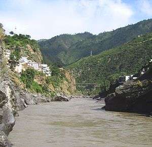 The sediment-laden Alaknanda river flowing into Devprayag, Uttarakhand. | |
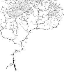 The Himalayan headwaters of the Ganges river in the Garhwal region of Uttarakhand, India. The Alaknanda is the left bank tributary of the Ganges at Devprayag. | |
| Native name | अलकनंदा |
| Location | |
| Country | India |
| State | Uttarakhand |
| Region | Garhwal division |
| District | Chamoli, Rudraprayag, Pauri Garhwal |
| Physical characteristics | |
| Source | Confluence of Satopanth Glacier and Bhagirathi Kharak Glacier |
| • elevation | 3,880 m (12,730 ft) |
| 2nd source | Bhagirathi River |
| Mouth | Ganges |
• location | Devprayag, Uttarakhand, India |
• elevation | 475 m (1,558 ft) |
| Length | 195 km (121 mi) |
| Basin size | 10,882 km2 (4,202 sq mi) |
| Discharge | |
| • average | 439.36 m3/s (15,516 cu ft/s) |
| Basin features | |
| Tributaries | |
| • left | Saraswati, Dhauliganga, Nandakini, Pindar |
| • right | Mandakini |
Overview
The Alaknanda is considered to rise at the confluence and foot of the Satopanth and Bhagirath Kharak glaciers in Uttarakhand[2][3] and meet the Sarasvati River tributary at Mana, India, 21 km from Tibet. Three km below Mana the Alaknanda flows past the Hindu pilgrimage centre of Badrinath.

The origin of Alaknanda River is of special interest to the tourists who visit the important pilgrimages in Uttarakhand. The Ganges as Alaknanda rises in the southern Himalayas on the Indian side of the Tibet border. On the Satopanth Glacier 6 km up from Alaknanda's origin at its snout, the triangular Lake Satopanth is found at a height of 4350 m and it is named after the Hindu trinity Lord Brahma, Lord Vishnu, Lord Shiva.
The five main tributaries joining with Alaknanda in order includes Dhauliganga, Nandakini, Pindar, Mandakini and Bhagirathi all rising in the northern mountainous regions of Uttarakhand. After the last tributary merging at Devprayag the river is known as the Ganges. The Alaknanda contributes a significantly larger portion to the flow of the Ganges than the Bhagirathi.
The Alaknanda river is among the best for river rafting in the world due to its high rafting grade.[4] The Alaknanda system drains parts of Chamoli, Tehri, and Pauri districts.[5]
Badrinath RishiGanga River meet Alaknanda
Badrinath, one of the holy destinations for Hindus in India is located near to the bank of the Alaknanda River. This place is surrounded by two mountain ranges of Nar and Narayan on either sides and Neelkanth peak located at the back of Narayan range.
- Govindgath :. LaxmanGanga meet Alaknanda
Several rivers in the Garhwal region merge with the Alaknanda at places called prayag or 'holy confluence of rivers'. These are:[6]
- Vishnuprayag, where the Alaknanda is met by the Dhauliganga River
- Nandaprayag, where it is met by the Nandakini River
- Karnaprayag, where it is met by the Pindar River
- Rudraprayag, where it is met by the Mandakini River
- Devprayag, where it meets the Bhagirathi River and officially becomes the Ganges
Dams
There are 37 hydroelectric dams in operation, under construction or planned to harness the energy of the Alaknanda river and its tributaries and generate electricity.[7]
| # | Name | Electrical output capacity (MW) | Status | Dam height (m) | Full reservoir level (MSL) (m) | River bed level at dam site (MSL) (m) | Head race tunnel length (km) | Tail race tunnel length (m) | Tail water level (MSL) (m) |
|---|---|---|---|---|---|---|---|---|---|
| 1 | Badrinath | 1.25 | operational | ||||||
| 2 | Tapovan | 0.8 | operational | ||||||
| 3 | Tharali | 0.4 | operational | ||||||
| 4 | Tilwara | 0.2 | operational | ||||||
| 5 | Urgam | 3 | operational | ||||||
| 6 | Vishnuprayag | 400 | operational | 14 | 11.323 | ||||
| 7 | Kaliganga-I | 4 | under construction | ||||||
| 8 | Kaliganga-II | 6 | under construction | ||||||
| 9 | Koti Bhel IB | 320 | under construction | 90 | 521 | 452.5 | 230 | 463.2 | |
| 10 | Koti Bhel II | 530 | under construction | 82 | 458.5 | 401.4 | 390 | 411.1 | |
| 11 | Madhamaheshwar | 10 | under construction | ||||||
| 12 | Tapovan Vishnugad | 520 | under construction | 22 | 803.5 | 513 | 1267 | ||
| 13 | Shrinagar | 330 | under construction | ||||||
| 14 | Singoli Bhatwari | 99 | under construction |
There are 23 other proposed projects in the Alaknanda river basin through which the power-potential of the Alaknanda and its tributaries can be harnessed. The proposed 23 hydel-projects are as follows -
- Alaknanda (Badrinath) (300 MW)
- Bagoli (72 MW)
- Bowla Nandprayag (132 MW)
- Chuni Semi (60 MW)
- Deodi (60 MW)
- Devsari Dam (255 MW)
- Gaurikund (18.6 MW)
- Gohana Tal (60 MW)
- Jelam Tamak (60 MW)
- Karnaprayag (160 MW)
- Lakshmanganga (4.4 MW)
- Lata Tapovan (310 MW)
- Maleri Jelam (55 MW)
- Nandprayag Langasu (141 MW)
- Padli Dam (27 MW)
- Phata-Byung (10.8 MW)
- Rambara (24 MW)
- Rishiganga I (70 MW)
- Rishiganga II (35 MW)
- Tamak Lata (280 MW)
- Urgam II (3.8 MW)
- Utyasu Dam (860 MW)
- Vishnugad Pipalkoti (444 MW)
Towns along the Alaknanda River
As the river flows, the towns along its banks are Badrinath, Vishnuprayag, Joshimath, Chamoli, Nandaprayag, Karnaprayag, Rudraprayag, Srinagar and Devprayag. At each town with suffix prayag, Alaknanda meets another river.
Photo gallery
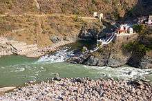
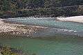 Alaknanda river near the town of Srinagar in Uttarakhand
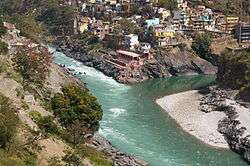
See also
References
- Gopal, Madan (1990). K.S. Gautam (ed.). India through the ages. Publication Division, Ministry of Information and Broadcasting, Government of India. p. 65.
- "eUttaranchal".
- In Hindu culture "The Story of Ganga : The River Goddess".
- "11 Top Destinations for River Rafting in India - Travel News India". travelnewsindia.com. 31 January 2017. Archived from the original on 11 March 2018. Retrieved 31 January 2017.
- Singh Negi, Sharad (1995). Uttarakhand: Land and People, page 6. MD Publications Pvt Ltd. ISBN 81-85880-73-5.
- Kapadia, Harish (2001). Trekking and Climbing in the Indian Himalaya, page 89. Stackpole Books. ISBN 0-8117-2953-2.
- Hydroelectric Projects on Alaknanda River Basin, by South Asia Network on Dams Rivers and People, www.sandrp.in
External links
| Wikimedia Commons has media related to Alaknanda River. |
- Alaknanda River Britannica.com
- Prayags at GMVN
| Authority control |
|
|---|