Son River
Son River (also spelt Sone) of central India is the second largest of the Ganges' southern tributaries after Yamuna River. The Kabra khurd is a beautiful place on the banks of the Son river, primarily due to its picnic spots.
| Son River | |
|---|---|
 | |
| Native name | Sone |
| Location | |
| Country | India |
| State | Chhattisgarh, Madhya Pradesh, Uttar Pradesh, Jharkhand, Bihar |
| Region | Baghelkhand, Palamu, Magadha |
| Cities | Sidhi, Dehri, Patna, Daudnagar |
| Physical characteristics | |
| Source | |
| • location | Amarkantak, Madhya Pradesh |
| • coordinates | 22°43′48″N 82°03′31″E |
| Mouth | Ganges River |
• location | Patna district, Bihar, India |
• coordinates | 25°42′21″N 84°51′44″E |
| Length | 784 km (487 mi) |
| Discharge | |
| • location | Ganges River |
| Basin features | |
| Tributaries | |
| • left | Ghaghar River, Johilla River, Chhoti Mahanadi River |
| • right | Gopad River, Rihand River, Kanhar River, North Koel River |
Course
The Sone originates near Amarkantak in Anuppur district of Madhya Pradesh,[2] just east of the headwater of the Narmada River, and flows north-northwest through Shahdol district in Madhya Pradesh state before turning sharply eastward where it encounters the southwest-northeast-Kaimur Range. The Sone parallels the Kaimur hills, flowing east-northeast through Uttar Pradesh, Jharkhand and Bihar states to join the Ganges just west of Patna. Geologically, the lower valley of the Son is an extension of the Narmada Valley, and the Kaimur Range an extension of the Vindhya Range. Anuppur, Chopan, Deori, Rohtasgarh, Dehri, Sonbhadra and Bihta are the major cities situated on Sone River.
The Sone river which is 784 kilometres (487 mi) long. But as per Google maps, the distance from Amarkantak to meeting point of Ganges is 932 kilometres (579 mi). Hence the actual length of this river is debatable. The Sone is one of the longest Indian rivers.[2] Its chief tributaries are the Rihand, Banas, Kanhar and the North Koel. The Son has a steep gradient (35–55 cm per km) with quick run-off and ephemeral regimes, becoming a roaring river with the rain-waters in the catchment area but turning quickly into a fordable stream. The Son, being wide and shallow, leaves disconnected pools of water in the remaining parts of the year. The channel of the Son is very wide (about 5 km at Dehri) but the floodplain is narrow, only 3 to 5 kilometres (2 to 3 mi) wide. The meeting point with North Koel the width of Sone River is 5 to 8 kilometres (3 to 5 mi). In the past, the Son has been notorious for changing course. As it is traceable from several old beds near its east bank, the river changed its course more than 5 times. In modern times this tendency has been checked with the anicut at Dehri, and now more so with the Indrapuri Barrage.
In Bihar, this river forms the border line between the Bhojpuri- and Magahi-speaking regions.
Sir John Houlton, the British administrator, described the Son as follows, "After passing the steep escarpments of the Kaimur range, it flows straight across the plain to the Ganges. For much of this distance it is over two miles wide, and at one point, opposite Tilothu three miles wide. In the dry weather there is a vast expanse of sand, with a stream not more than a hundred yards wide, and the hot west winds pile up the sand on the east bank, making natural embankments. After heavy rain in the hills even this wide bed cannot carry the waters of the Son and disastrous floods in Shahabad, Gaya, and Patna are not uncommon."[3]
Dams
The first dam on the Son was built in 1873–74 at Dehri.
The Indrapuri Barrage was constructed, 8 kilometres (5 mi) upstream, and commissioned in 1968.[4]
The Bansagar Dam in Madhya Pradesh was commissioned in 2008.
Bridges
The 1440-metre rail and road lattice-girder concrete and steel Abdul Bari Bridge (previously but widely still called the Koilwar Bridge and before that the Son Bridge) near Arrah was completed in 1862.[5] It remained the longest bridge in India, until the Nehru Setu bridge at Dehri was opened in 1900.[3][6] After Nehru Setu bridge at Dehri, Railway Bridges are present on Sone River near Chopan, Vijay Sota & Anuppur.
The modern Son bridge built in Deolond, Shahdol district of Madhya Pradesh was inaugurated by Motilal Vora and Pandit Ram Kishore Shukla then Chief Minister and Finance Minister of Madhya Pradesh on 13 February 1986.
The Government of Bihar sanctioned in 2008 a bridge across the Son River connecting Arwal and Sahar in Bhojpur district.[7]
A four-lane road bridge, carrying NH 30, parallel to the existing rail and road Koilwar Bridge, has been planned.[8]
Gallery
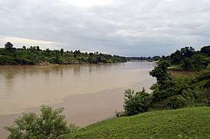
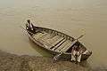 Boatmen on the Son River, Umaria district, MP
 Son River, from Son Nagar railway station, Aurangabad district, Bihar
 Son River, from Son Nagar railway station , Aurangabad district , Bihar
See also
References
- "Baburnama". 1590s. Archived from the original on 17 October 2013.
- Sir William Wilson Hunter. Imperial gazetteer of India, Volume 23. pp. 76–78. Archived from the original on 14 July 2014. Retrieved 6 June 2014.
- Houlton, Sir John, Bihar, the Heart of India, pp. 47–48, Orient Longmans, 1949.
- "Performance Evaluation of Patna Main Canal" (PDF). ICAR Research Complex for Eastern Region. Archived (PDF) from the original on 26 March 2012. Retrieved 8 July 2011.
- "Bridges: The Spectacular Feat of Indian Railways" (PDF). National Informatics Centre. Archived from the original (pdf) on 5 March 2016. Retrieved 5 July 2011.
- "Longest railway bridge in Kochi". ForumCo.com. Archived from the original on 23 March 2012. Retrieved 7 July 2011.
- "Arwal". The Bihar, 31 March 2010. Archived from the original on 6 April 2010. Retrieved 3 July 2011.
- "Four-lane connector over Sone, Ganga". The Telegraph, 8 April 2011. Archived from the original on 26 June 2012. Retrieved 25 June 2011.
| Wikimedia Commons has media related to Son River. |
| Authority control |
|
|---|