Hamirpur district, Himachal Pradesh
Hamirpur district is the districts of the state of Himachal Pradesh in northern India. The headquarters of the district is in the town of Hamirpur. With an area of 1,118 square kilometres or 432 square miles it is the smallest district of Himachal Pradesh.
Hamirpur district | |
|---|---|
District of Himachal Pradesh | |
 Location of Hamirpur district in Himachal Pradesh | |
| Country | India |
| State | Himachal Pradesh |
| Division | 5 |
| Established | 1972 |
| Headquarters | Hamirpur, Himachal Pradesh |
| Tehsils | 5+2(Sub-Tehsils)[1] |
| Government | |
| • Parliament of India Constituency | Hamirpur |
| • Member of Parliament | Anurag Singh Thakur |
| • Vidhan Sabha constituencies | Barsar, Hamirpur, Sujanpur, Nadaun, Bhoranj. |
| Area | |
| • Total | 1,118 km2 (432 sq mi) |
| Population (2011) | |
| • Total | 454,768 |
| • Density | 410/km2 (1,100/sq mi) |
| Demographics | |
| • Literacy | 90% |
| Time zone | UTC+05:30 (IST) |
| Website | http://hphamirpur.nic.in/ |
History
Carved out from Kangra District in 1972, Hamirpur District is closely associated with the Katoch dynasty. It was the part of old Jalandhar-Trigarta empire. Panin referred to the people of this kingdom as great warriors and fighters. Even today Army is the largest employer for Hamirpuris, who form large bulks of Dogra Regiment, Jammu and Kashmir Riflespunjab regiment, the grenadiers, Rajput regiment as well as Hodson's Horse and Scinde Horse.
The Katoch dynasty predominated during the period of Raja Hamir Chand who ruled from 1700 to 1740. It was Raja Hamir Chand who built the fort at Hamirpur and the present town derived its name from this ruler.
Geography
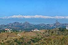
Hamirpur District is situated between 31°25′N and 31°52′N and between 76°18′E and 76°44′E. Hamirpur(town), the district headquarters, is situated at an altitude of 780 m .
The district shares borders with the neighbouring districts of Mandi to the East, Bilaspur to the South,Una to the West, and Kangra to the North.

River Beas separates Hamirpur from Kangra and is a parent river to two tributaries, namely Maan Khad and Kunah Khad('Khad' is a word used to describe a rivulet) flowing across either sides of Hamirpur district, to the adjacent Setluj. Hamirpur district has considerable amount of pine forests. Hamirpur is also a home to mango trees.
Climate
Hamirpur has the“Hilly & Chilly” type of climate found in most of Himachal Pradesh. During winter, the climate is cold. woolens are required after August up to end of March . During summers, the temperature ofen crosses 40 °C and cottons are recommended. It does not normally snow in the district but in January, 2012 (after 44 years) and February, 2019 some parts of Hamirpur district were reported to receive moderate snowfall.

Divisions
The district comprises five sub-divisions: Hamirpur, Barsar, Nadaun, Sujanpur and Bhoranj.
Hamirpur district divided in to 7 tehsils:
1. Hamirpur Sadar 2. Nadaun 3. Sujanpur 4. Badsar 5. Bhoranj 6. Tauni Devi (Sub Tehsil) 7. Galore ( Sub Tehsil)[2]
There are five Vidhan Sabha constituencies in this district: Barsar, Hamirpur, Sujanpur, Nadaun and Bhoranj. All of these are part of the Hamirpur Lok Sabha constituency.
Demography
According to the 2011 census, Hamirpur district has a population of 454,768, This gives it a ranking of 550th in India (out of a total of 640). The district has a population density of 407 inhabitants per square kilometre (1,050/sq mi) highest in the state. Its population growth rate over the decade 2001–2011 was 10.19%. Hamirpur has a sex ratio of 1095 (i.e- females for every 1000 males)again highest in the state, and a literacy rate of 88.15% again highest in the state.[3][4]
At the 2011 Census of India, 76% of the population declared their first language to be Pahari, 14.1% chose Hindi, 3.55% – Kangri, and 0.75% – Dogri.[5]
| Historical population | ||
|---|---|---|
| Year | Pop. | ±% p.a. |
| 1901 | 160,374 | — |
| 1911 | 157,251 | −0.20% |
| 1921 | 157,319 | +0.00% |
| 1931 | 165,837 | +0.53% |
| 1941 | 188,804 | +1.31% |
| 1951 | 191,311 | +0.13% |
| 1961 | 220,341 | +1.42% |
| 1971 | 264,991 | +1.86% |
| 1981 | 317,751 | +1.83% |
| 1991 | 369,128 | +1.51% |
| 2001 | 412,700 | +1.12% |
| 2011 | 454,768 | +0.98% |
| source:[6] | ||
References
- https://www.census2011.co.in/data/district/234-hamirpur-himachal-pradesh.html
- https://www.census2011.co.in/data/district/234-hamirpur-himachal-pradesh.html
- "District Census 2011". Census2011.co.in. 2011. Retrieved 30 August 2014.
- "List of districts of Himachal Pradesh by population", Wikipedia, 2 November 2019, retrieved 28 March 2020
- 2011 Census of India, Population By Mother Tongue
- Decadal Variation In Population Since 1901
External links
- Hamirpur district website
- DISTRICT PROFILE
- CULTURAL & TOURISM HERITAGE OF THE DISTRICT
- Developmental Data of the District
- Himachal tourism
Places adjacent to Hamirpur district, Himachal Pradesh | ||||||||||
|---|---|---|---|---|---|---|---|---|---|---|
| ||||||||||
| Topics | |||||||
|---|---|---|---|---|---|---|---|
| History |
| ||||||
| Culture | |||||||
| Jurisdiction | |||||||
| Districts and divisions |
| ||||||
| Major cities | |||||||
| Economy | |||||||
| Geography | |||||||
| Images and Others | |||||||
| Lakes |  | |
|---|---|---|
| Rivers | ||
| Districts | ||
| Other |
| |
| Authority control |
|
|---|