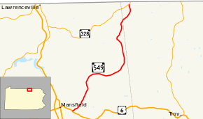
Pennsylvania Route 549
Pennsylvania Route 549 (designated by the Pennsylvania Department of Transportation as SR 549) is a 19.15-mile-long (30.82 km) state highway located in Tioga and Bradford counties in Pennsylvania. The southern terminus is at U.S. Route 6 in Richmond Township near Mansfield. The northern terminus is at Route 328 in Wells Township. Route 549 was first designated in 1928 onto the current alignment from Richmond Township and U.S. Route 6 to an intersection with then-Route 826 in Wells Township. This was changed in 1941 to extend to the New York state line nearby, but was extended and truncated twice between 1946 and 1961. In 1961, it was truncated to its current alignment.
| ||||
|---|---|---|---|---|
 | ||||
| Route information | ||||
| Maintained by PennDOT | ||||
| Length | 19.15 mi[1] (30.82 km) | |||
| Existed | 1928–present | |||
| Major junctions | ||||
| South end | ||||
| North end | ||||
| Location | ||||
| Counties | Tioga, Bradford | |||
| Highway system | ||||
| ||||

Route description
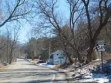
Route 549 begins at an intersection with U.S. Route 6 (East Roosevelt Highway) just east of Mansfield, Pennsylvania in Richmond Township. The route progresses northeast as Roseville Road, crawling through farms for a distance until the intersection with Tickner Lane, where it curves north. Entering Rutland Township, Route 549 remains rural, curving eastward and soon southeastward into the community of Roseville. Through Roseville, the road remains two-lane and passes residences and businesses before leaving just east of Pumpkin Hill Road. Route 549 forks to the northeast at an intersection with Sopertown Road, which heads into Bradford County and becomes Quadrant Route 4033. The highway parallels the Bradford County line for a distance, remaining primarily rural. After the intersection, Route 549 turns due north and soon to the northwest, entering the hamlet of Jobs Corners. Jobs Corners is small, with Route 549 passing some residences before turning to the northeast out of the hamlet. A short distance later, the highway enters Daggett and passes a small strip of buildings through downtown. The highway curves to the northwest at a gravel pit and turns northeastward once again, crossing the county line into Bradford County.[2]
After crossing the county line from Tioga County, Route 549 immediately enters the hamlet of Mosherville. Through the hamlet, the highway turns northeastward, passing some residences to the northern end and turning northward after the intersection with School Street. Route 549 begins a short parallel with Hammond Creek, before crossing over north of Mosherville. Continuing through Wells Township, Route 549 intersects with Farm View Road and soon merges in with Route 328 (Hammond Creek Road) just south of the New York state line. This junction serves as the northern terminus for Route 549.[2]
History
Route 549 was first designated from the intersection with U.S. Route 6 to an intersection with then Route 826 in Wells Township during the numbering of state highways in Pennsylvania in 1928.[3] This remained in place for 13 years, until Route 549 was extended to the Pennsylvania/New York state line along old Route 826.[4] Five years later, in 1946, Route 549 was truncated once again in place of now Route 84 in Wells Township.[5] In 1951, five years after the truncation, Route 549 was moved back to the Pennsylvania/New York state line.[6] This extension lasted only ten years, as Route 549 was truncated back for the final time now to Route 328 in 1961.[7]
Major intersections
| County | Location | mi[1] | km | Destinations | Notes |
|---|---|---|---|---|---|
| Tioga | Richmond Township | 0.00 | 0.00 | Southern terminus of Route 549. | |
| Bradford | Wells Township | 19.15 | 30.82 | Northern terminus of Route 549. | |
| 1.000 mi = 1.609 km; 1.000 km = 0.621 mi | |||||
See also


References
- Overview map of Pennsylvania Route 549 (Map). Cartography by NAVTEQ. Yahoo Maps. Retrieved July 20, 2010.
- Microsoft; Nokia (August 17, 2011). "Overview map of Pennsylvania Route 549" (Map). Bing Maps. Microsoft. Retrieved August 17, 2011.
- Map Showing Pennsylvania State Highways (Map). Pennsylvania Department of Highways. 1928.
- Pennsylvania Official Road Map (Map). Pennsylvania Department of Highways. 1941.
- Pennsylvania Official Road Map (Map). Pennsylvania Department of Highways. 1946.
- Pennsylvania Official Road Map (Map). Pennsylvania Department of Highways. 1951.
- Pennsylvania Official Road Map (Map). Pennsylvania Department of Highways. 1961.
External links
| Wikimedia Commons has media related to Pennsylvania Route 549. |
- Kitsko, Jeffrey J. (2020). "PA 549". Pennsylvania Highways. pp. 501–550. Retrieved July 20, 2010.