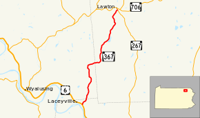
Pennsylvania Route 367
Pennsylvania Route 367 (designated by the Pennsylvania Department of Transportation as SR 367) is a 12.53-mile (20.17 km) long state highway located in Wyoming, Bradford, and Susquehanna counties in Pennsylvania. The southern terminus is at US 6 in Braintrim Township near the borough of Laceyville. The northern terminus is at PA 267 in the hamlet of Lawton, part of Rush Township.
| ||||
|---|---|---|---|---|
 | ||||
| Route information | ||||
| Maintained by PennDOT | ||||
| Length | 12.53 mi[1] (20.16 km) | |||
| Major junctions | ||||
| South end | ||||
| North end | ||||
| Location | ||||
| Counties | Wyoming, Bradford, Susquehanna | |||
| Highway system | ||||
| ||||

Route description
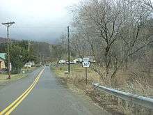
Route 367 begins at an intersection with U.S. Route 6 (the Grand Army of the Republic Highway) in the hamlet of Skinners Eddy, just east of Laceyville. The route progresses northeastward as a two-lane road, paralleling Eddy Mountain Road through some houses. After curving further to the northeast, the road becomes predominantly rural and leaves Wyoming County for Bradford County. In Bradford County, Route 367 enters Tuscarora Township. Just after the county line, Quadrant Route 1014 terminates at Route 367. The route remains wooded, weaving its way northward through Tuscarora Township along the side of a pond. After the pond, the highway makes a short beeline to the northwest before turning northward once again. A short distance after the curve, the route curves once again, this time to the northwest and enters the hamlet of Silvara. There, the route forks to the northeast out of the woods intersecting with Quadrant Routes 1002 (Turkey Path Road), 1003 (Steam Mill Hollow Road) and 1001 (Clapper Hill Road). After Route 1001, Route 367 turns eastward out of Silvara and crosses Coburn Hill into Susquehanna County.[2]
After crossing into Susquehanna County, Route 367 passes to the south of a large pond and intersects with Quadrant Route 3005, where the main road turns to the north. Paralleling the pond, Route 367 enters Auburn Township and the hamlet of West Auburn. Through Auburn, Route 367 passes some residences and an intersection with Quadrant Route 3004. At the intersection with Township Road 337, Route 367 leaves West Auburn. Route 367 becomes rural, weaving northward for several miles. At the intersection with Sink Road, the route turns to the northeast. Route 367 passes a large pond and intersects with Township Road 210. The route returns to its northern progression and intersects with Township Roads 600 and 422. There, the route turns northeastward into Rush Township. Through Rush Township, Route 367 changes directions several times and curves one final time to the northeast. Soon, Route 367 enters the hamlet of Lawton, where it intersects with Route 267 and terminates. The road continues as a township road to the intersection with Route 706 nearby.[2]
Major intersections
| County | Location | mi[1] | km | Destinations | Notes |
|---|---|---|---|---|---|
| Wyoming | Braintrim Township | 0.000 | 0.000 | Hamlet of Skinners Eddy | |
| Bradford | Tuscarora Township | No major junctions | |||
| Susquehanna | Rush Township | 12.527 | 20.160 | Hamlet of Lawton | |
| 1.000 mi = 1.609 km; 1.000 km = 0.621 mi | |||||
PA 367 Truck
| |
|---|---|
| Location | Susquehanna County |
| Existed | 2013–present |
Pennsylvania Route 367 Truck is a truck route that bypasses a weight restricted bridge over a branch of the Tuscarora Creek, on which trucks over 29 tons and combination loads over 40 tons are prohibited. The route follows PA 267 and State Route 3004 through Susquehanna County, Pennsylvania, and it was signed in 2013.
See also


References
- "Pennsylvania state roads". Pennsylvania Spatial Data Access. Pennsylvania Department of Transportation. 2013. Retrieved March 14, 2013.
- Microsoft; Nokia (August 4, 2011). "Overview map of Pennsylvania Route 367" (Map). Bing Maps. Microsoft. Retrieved August 4, 2011.
External links
- Kitsko, Jeffrey J. (2011). "PA 367". Pennsylvania Highways. Retrieved August 4, 2011.