Wilmot, New Hampshire
Wilmot is a town in Merrimack County, New Hampshire, United States. The population was 1,358 at the 2010 census.[1] Wilmot is home to Winslow State Park and a small part of Gile State Forest. The town includes the villages of Wilmot, Wilmot Flat, and North Wilmot.
Wilmot, New Hampshire | |
|---|---|
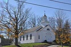 Wilmot Baptist Church, in Wilmot Flat | |
 Seal | |
 Location in Merrimack County and the state of New Hampshire. | |
| Coordinates: 43°27′03″N 71°54′48″W | |
| Country | United States |
| State | New Hampshire |
| County | Merrimack |
| Incorporated | 1794 |
| Villages | Wilmot Wilmot Flat North Wilmot |
| Government | |
| • Board of Selectmen | Gary Palumbo, Chair Chris Wells Thomas Schamberg |
| Area | |
| • Total | 29.8 sq mi (77.1 km2) |
| • Land | 29.6 sq mi (76.5 km2) |
| • Water | 0.2 sq mi (0.6 km2) 0.74% |
| Elevation | 873 ft (266 m) |
| Population (2010) | |
| • Total | 1,358 |
| • Density | 46/sq mi (18/km2) |
| Time zone | UTC-5 (Eastern) |
| • Summer (DST) | UTC-4 (Eastern) |
| ZIP code | 03287 |
| Area code(s) | 603 |
| FIPS code | 33-84900 |
| GNIS feature ID | 0873755 |
| Website | www |
History
Incorporated in 1807 from part of New London, the town took its name from Dr. James Wilmot, an English clergyman who had spoken out against England's treatment of the American colonies. Dr. Wilmot was rector at Barton-on-Heath in Warwickshire, England.[2]
Geography
Wilmot is in northwestern Merrimack County, in the Dartmouth–Lake Sunapee Region of New Hampshire. According to the United States Census Bureau, the town has a total area of 29.8 square miles (77.2 km2), of which 29.5 sq mi (76.4 km2) is land and 0.2 sq mi (0.5 km2), or 0.74%, is water. Wilmot is drained by the Blackwater River and Kimpton Brook.
The village of Wilmot is near the center of the town and is along New Hampshire Route 4A. Wilmot Flat is a village in the southern part of the town, served by New Hampshire Route 11. North Wilmot is a rural community centered on the junction of North Wilmot Road and Hobbs Hill Road, north of White Pond.
Mount Kearsarge, elevation 2,931 feet (893 m) above sea level, on the southeastern border, is the highest point in town. Winslow State Park, at the northern foot of the mountain, provides access by two hiking trails to the summit. The state park and the Winslow Trail are named after Captain John Winslow, the commander of the USS Kearsarge, which in June 1864 sank the CSS Alabama in the English Channel in a famous Civil War sea battle.
The town is the home of Camps Kenwood and Evergreen on Eagle Pond.
Adjacent municipalities
- Grafton, New Hampshire (north)
- Danbury, New Hampshire (northeast)
- Andover, New Hampshire (east)
- Warner, New Hampshire (southeast)
- Sutton, New Hampshire (south)
- New London, New Hampshire (southwest)
- Springfield, New Hampshire (west)
Demographics
| Historical population | |||
|---|---|---|---|
| Census | Pop. | %± | |
| 1810 | 298 | — | |
| 1820 | 670 | 124.8% | |
| 1830 | 834 | 24.5% | |
| 1840 | 1,212 | 45.3% | |
| 1850 | 1,272 | 5.0% | |
| 1860 | 1,195 | −6.1% | |
| 1870 | 1,072 | −10.3% | |
| 1880 | 1,080 | 0.7% | |
| 1890 | 840 | −22.2% | |
| 1900 | 653 | −22.3% | |
| 1910 | 614 | −6.0% | |
| 1920 | 536 | −12.7% | |
| 1930 | 495 | −7.6% | |
| 1940 | 466 | −5.9% | |
| 1950 | 370 | −20.6% | |
| 1960 | 391 | 5.7% | |
| 1970 | 516 | 32.0% | |
| 1980 | 725 | 40.5% | |
| 1990 | 935 | 29.0% | |
| 2000 | 1,144 | 22.4% | |
| 2010 | 1,358 | 18.7% | |
| Est. 2017 | 1,381 | [3] | 1.7% |
| U.S. Decennial Census[4] | |||
As of the census[5] of 2000, there were 1,144 people, 459 households, and 329 families residing in the town. The population density was 38.7 people per square mile (15.0/km²). There were 530 housing units at an average density of 17.9 per square mile (6.9/km²). The racial makeup of the town was 98.25% White, 0.09% African American, 0.09% Native American, 0.61% Asian, 0.09% Pacific Islander, and 0.87% from two or more races. Hispanic or Latino of any race were 0.26% of the population.
There were 459 households out of which 34.2% had children under the age of 18 living with them, 60.6% were married couples living together, 7.4% had a female householder with no husband present, and 28.3% were non-families. 22.4% of all households were made up of individuals and 7.4% had someone living alone who was 65 years of age or older. The average household size was 2.49 and the average family size was 2.93.

In the town, the population was spread out with 26.0% under the age of 18, 4.4% from 18 to 24, 27.0% from 25 to 44, 29.5% from 45 to 64, and 13.1% who were 65 years of age or older. The median age was 42 years. For every 100 females, there were 93.6 males. For every 100 females age 18 and over, there were 93.4 males.
The median income for a household in the town was $49,605, and the median income for a family was $57,143. Males had a median income of $37,857 versus $30,278 for females. The per capita income for the town was $25,629. About 1.8% of families and 4.4% of the population were below the poverty line, including 5.8% of those under age 18 and 1.4% of those age 65 or over.
Notable people
- Donald Hall (1928-2018), United States Poet Laureate (2006)
- Jane Kenyon (1947–1995), poet and translator
References
- United States Census Bureau, U.S. Census website, 2010 Census figures. Retrieved March 23, 2011.
- "Wilmot NH - Community Profile | Economic & Labor Market Information Bureau | NH Employment Security". www.nhes.nh.gov. Retrieved 2016-01-19.
- "Annual Estimates of the Resident Population: April 1, 2010 to July 1, 2017 (PEPANNRES): Minor Civil Divisions – New Hampshire". Archived from the original on February 13, 2020. Retrieved November 15, 2018.
- "Census of Population and Housing". Census.gov. Retrieved June 4, 2016.
- "U.S. Census website". United States Census Bureau. Retrieved 2008-01-31.
External links
| Wikimedia Commons has media related to Wilmot, New Hampshire. |
- Town of Wilmot official website
- Wilmot Historical Society
- New Hampshire Economic and Labor Market Information Bureau Profile
- Winslow State Park
- Sunapee-Ragged-Kearsarge Greenway Coalition
Places adjacent to Wilmot, New Hampshire | |
|---|---|
Municipalities and communities of Merrimack County, New Hampshire, United States | ||
|---|---|---|
| Cities | 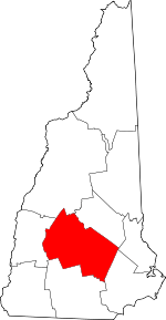 Map of New Hampshire highlighting Merrimack County | |
| Towns | ||
| CDPs | ||
| Other unincorporated communities | ||
| Footnotes | ‡This populated place also has portions in an adjacent county or counties | |
| Authority control |
|
|---|