Bradford, New Hampshire
Bradford is a town in Merrimack County, New Hampshire, United States. The population was 1,650 at the 2010 census.[1] The main village of the town, where 356 people resided at the 2010 census,[1] is defined as the Bradford census-designated place (CDP), and is located in the northeast part of the town, west of the junction of New Hampshire routes 103 and 114. The town also includes the village of Bradford Center.
Bradford, New Hampshire | |
|---|---|
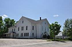 Bradford Town Hall | |
 Seal | |
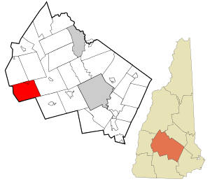 Location in Merrimack County and the state of New Hampshire. | |
| Coordinates: 43°16′12″N 71°57′36″W | |
| Country | United States |
| State | New Hampshire |
| County | Merrimack |
| Incorporated | 1787 |
| Villages | Bradford Bradford Center |
| Government | |
| • Board of Selectmen | Michael James, Chair John Pfeifle Jason Allen |
| • Town Administrator | Karen Hambleton |
| Area | |
| • Total | 36.0 sq mi (93.3 km2) |
| • Land | 35.3 sq mi (91.5 km2) |
| • Water | 0.7 sq mi (1.8 km2) 1.94% |
| Elevation | 686 ft (209 m) |
| Population (2010) | |
| • Total | 1,650 |
| • Density | 46/sq mi (18/km2) |
| Time zone | UTC-5 (Eastern) |
| • Summer (DST) | UTC-4 (Eastern) |
| ZIP code | 03221 |
| Area code(s) | 603 |
| FIPS code | 33-06980 |
| GNIS feature ID | 0873549 |
| Website | www |
History
Granted by Governor Benning Wentworth in 1765 [2] to John Pierce and George Jaffrey of Portsmouth, it was settled in 1771 by Dea. William Presbury and family.[3] Three years later other settlers arrived, several of them from Bradford, Massachusetts, after which the town was named New Bradford. Later, it was called Bradfordton, but upon incorporation by the General Court on September 27, 1787, it was officially named Bradford.[4]
Parts of the town are hilly, but the largest portion is in a valley with varied soil. Streams provided water power for watermills. By 1859, when Bradford's population reached 1,341, industries included one woolen mill, one sash, blind and door factory, one wheelwright shop, two sawmills, one gristmill, one tannery, and one clothing mill.[4] In 1850, the Concord & Claremont Railroad opened from Concord to Bradford, which would remain its terminus until the line was extended to Claremont in 1871-72.[5]
 Concord & Claremont Railroad depot in 1906
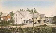
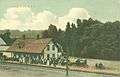
 The Bradford Hotel in 1906
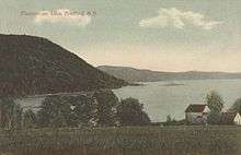 Lake Massasecum in 1909
Geography
According to the United States Census Bureau, the town has a total area of 36.0 square miles (93 km2), of which 35.3 sq mi (91 km2) is land and 0.7 sq mi (1.8 km2) is water, comprising 1.94% of the town. The village of Bradford is located near the northern border of the town, at the intersection of routes 103 and 114, just north of the Warner River and adjacent to the outlet of Todd Lake. The largest water body in the town is Lake Massasecum, near the town's eastern border.
The highest point in Bradford is an unnamed 2,096-foot (639 m) summit overlooking Ayers Pond on the town's western border. Knights Hill—1,910 ft (580 m) above sea level—and Rowes Hill—1,950 ft (590 m)—constitute a large, hilly mass occupying the southern portion of town. Bradford lies fully within the Merrimack River watershed.[6]
Adjacent municipalities
- Newbury, New Hampshire (north)
- Sutton, New Hampshire (northeast)
- Warner, New Hampshire (east)
- Henniker, New Hampshire (southeast)
- Hillsborough, New Hampshire (south)
- Washington, New Hampshire (west)
Demographics
| Historical population | |||
|---|---|---|---|
| Census | Pop. | %± | |
| 1790 | 217 | — | |
| 1800 | 740 | 241.0% | |
| 1810 | 1,034 | 39.7% | |
| 1820 | 1,318 | 27.5% | |
| 1830 | 1,285 | −2.5% | |
| 1840 | 1,331 | 3.6% | |
| 1850 | 1,341 | 0.8% | |
| 1860 | 1,180 | −12.0% | |
| 1870 | 1,081 | −8.4% | |
| 1880 | 950 | −12.1% | |
| 1890 | 810 | −14.7% | |
| 1900 | 805 | −0.6% | |
| 1910 | 695 | −13.7% | |
| 1920 | 580 | −16.5% | |
| 1930 | 587 | 1.2% | |
| 1940 | 661 | 12.6% | |
| 1950 | 606 | −8.3% | |
| 1960 | 508 | −16.2% | |
| 1970 | 679 | 33.7% | |
| 1980 | 1,115 | 64.2% | |
| 1990 | 1,405 | 26.0% | |
| 2000 | 1,454 | 3.5% | |
| 2010 | 1,650 | 13.5% | |
| Est. 2017 | 1,685 | [7] | 2.1% |
| U.S. Decennial Census[8] | |||
As of the census of 2010, there were 1,650 people, 667 households, and 471 families residing in the town. There were 917 housing units, of which 250, or 27.3%, were vacant. 203 of the vacant units were for seasonal or recreational uses. The racial makeup of the town was 97.5% white, 0.1% African American, 0.4% Native American, 0.2% Asian, 0.1% Native Hawaiian or Pacific Islander, 0.2% some other race, and 1.6% from two or more races. 1.3% of the population were Hispanic or Latino of any race.[9]
Of the 667 households, 29.1% had children under the age of 18 living with them, 57.7% were headed by married couples living together, 7.8% had a female householder with no husband present, and 29.4% were non-families. 21.1% of all households were made up of individuals, and 7.1% were someone living alone who was 65 years of age or older. The average household size was 2.47, and the average family size was 2.86.[9]
In the town, 20.7% of the population were under the age of 18, 6.3% were from 18 to 24, 20.9% from 25 to 44, 38.9% from 45 to 64, and 13.2% were 65 years of age or older. The median age was 46.3 years. For every 100 females, there were 100.7 males. For every 100 females age 18 and over, there were 100.6 males.[9]
For the period 2011-2015, the estimated median annual income for a household was $59,783, and the median income for a family was $68,750. Male full-time workers had a median income of $55,119 versus $40,000 for females. The per capita income for the town was $28,152. 7.1% of the population and 4.8% of families were below the poverty line. 7.8% of the population under the age of 18 and 8.5% of those 65 or older were living in poverty.[10]
Sites of interest
- Bement Covered Bridge, built 1854
Notable people
- Odds Bodkin, storyteller and musician
- John Q. A. Brackett, 36th governor of Massachusetts
- John Milton Hawks, abolitionist and physician
- Thorkild Jacobsen, Danish-American historian
- Mason Tappan, US Congressman and State Attorney General
- Bainbridge Wadleigh, US senator
References
- United States Census Bureau, U.S. Census website, 2010 Census figures. Retrieved March 23, 2011.
- Hayward's New England Gazetteer of 1839
- Nathaniel Bouton, Documents and Records Relating to Towns in New Hampshire; Concord, New Hampshire 1875
- Austin J. Coolidge & John B. Mansfield, A History and Description of New England; Boston, Massachusetts 1859
- Nashua City Station Railroad History -- The Concord & Claremont Railroad
- Foster, Debra H.; Batorfalvy, Tatianna N.; Medalie, Laura (1995). Water Use in New Hampshire: An Activities Guide for Teachers. U.S. Department of the Interior and U.S. Geological Survey.
- "Annual Estimates of the Resident Population: April 1, 2010 to July 1, 2017 (PEPANNRES): Minor Civil Divisions – New Hampshire". Archived from the original on February 13, 2020. Retrieved November 15, 2018.
- "Census of Population and Housing". Census.gov. Retrieved June 4, 2016.
- "Profile of General Population and Housing Characteristics: 2010 Census Summary File 1 (DP-1): Bradford town, Merrimack County, New Hampshire". American Factfinder. U.S. Census Bureau. Archived from the original on February 13, 2020. Retrieved November 2, 2017.
- "Selected Economic Characteristics: 2011-2015 American Community Survey 5-Year Estimates (DP03): Bradford town, Merrimack County, New Hampshire". American Factfinder. U.S. Census Bureau. Archived from the original on February 13, 2020. Retrieved November 2, 2017.
External links
- Town of Bradford official website
- Bradfordnh.com
- Brown Memorial Library
- New Hampshire Economic and Labor Market Information Bureau Profile
Places adjacent to Bradford, New Hampshire | |
|---|---|
Municipalities and communities of Merrimack County, New Hampshire, United States | ||
|---|---|---|
| Cities | 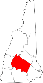 Map of New Hampshire highlighting Merrimack County | |
| Towns | ||
| CDPs | ||
| Other unincorporated communities | ||
| Footnotes | ‡This populated place also has portions in an adjacent county or counties | |
| Authority control |
|
|---|