Salisbury, New Hampshire
Salisbury is a town in Merrimack County, New Hampshire, United States. The population was 1,382 at the 2010 census.[1]
Salisbury, New Hampshire | |
|---|---|
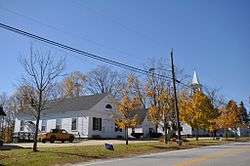 Old town hall and church (now historic society) | |
 Seal | |
 Location in Merrimack County and the state of New Hampshire | |
| Coordinates: 43°22′43″N 71°43′03″W | |
| Country | United States |
| State | New Hampshire |
| County | Merrimack |
| Incorporated | 1768 |
| Villages | Salisbury Salisbury Heights West Salisbury |
| Government | |
| • Board of selectmen | Ken Ross‑Raymond, Chair Pete Ballou Jim Hoyt |
| • Town Administrator | Margaret Warren |
| Area | |
| • Total | 40.2 sq mi (104.1 km2) |
| • Land | 40.0 sq mi (103.5 km2) |
| • Water | 0.3 sq mi (0.7 km2) 0.65% |
| Elevation | 819 ft (250 m) |
| Population (2010) | |
| • Total | 1,382 |
| • Density | 34/sq mi (13/km2) |
| Time zone | UTC−5 (Eastern) |
| • Summer (DST) | UTC−4 (Eastern) |
| ZIP code | 03268 |
| Area code(s) | 603 |
| FIPS code | 33-66980 |
| GNIS feature ID | 0873714 |
| Website | www |
History
While still part of Massachusetts, the town was granted as "Baker's Town" after Captain Thomas Baker in 1736. After the border between Massachusetts and New Hampshire was fixed, the town was on the New Hampshire side of the border. It was re-granted by the Masonian proprietors in 1749 with the name "Stevenstown", named after Colonel Ebenezer Stevens of Kingston and settled as early as 1750. Additionally known as "Gerrishtown" and "New Salisbury", the name "Salisbury" was taken when the town incorporated in 1768.[2]
Geography
According to the United States Census Bureau, the town has a total area of 40.2 square miles (104.1 km2), of which 40.0 sq mi (103.6 km2) is land and 0.3 sq mi (0.8 km2) is water, comprising 0.65% of the town. The highest point in Salisbury is along its western boundary, where the eastern slopes of Mount Kearsarge climb to 1,910 feet (580 m) above sea level.
The Blackwater River, part of the Merrimack River watershed, runs through Salisbury. A popular fishing and recreation spot is The Bay, a natural lake-like section of the river.
Adjacent municipalities
- Andover, New Hampshire (north)
- Franklin, New Hampshire (northeast)
- Boscawen, New Hampshire (east)
- Webster, New Hampshire (south)
- Warner, New Hampshire (west)
Demographics
| Historical population | |||
|---|---|---|---|
| Census | Pop. | %± | |
| 1790 | 1,372 | — | |
| 1800 | 1,767 | 28.8% | |
| 1810 | 1,913 | 8.3% | |
| 1820 | 2,016 | 5.4% | |
| 1830 | 1,379 | −31.6% | |
| 1840 | 1,332 | −3.4% | |
| 1850 | 1,228 | −7.8% | |
| 1860 | 1,191 | −3.0% | |
| 1870 | 897 | −24.7% | |
| 1880 | 795 | −11.4% | |
| 1890 | 655 | −17.6% | |
| 1900 | 604 | −7.8% | |
| 1910 | 478 | −20.9% | |
| 1920 | 390 | −18.4% | |
| 1930 | 350 | −10.3% | |
| 1940 | 368 | 5.1% | |
| 1950 | 423 | 14.9% | |
| 1960 | 415 | −1.9% | |
| 1970 | 589 | 41.9% | |
| 1980 | 781 | 32.6% | |
| 1990 | 1,061 | 35.9% | |
| 2000 | 1,137 | 7.2% | |
| 2010 | 1,382 | 21.5% | |
| Est. 2017 | 1,418 | [3] | 2.6% |
| U.S. Decennial Census[4] | |||
At the 2000 census there were 1,137 people, 435 households, and 324 families in the town. The population density was 28.5 people per square mile (11.0/km²). There were 514 housing units at an average density of 12.9 per square mile (5.0/km²). The racial makeup of the town was 97.80% White, 0.70% African American, 0.26% Asian, 0.09% Pacific Islander, 0.18% from other races, and 0.97% from two or more races. Hispanic or Latino of any race were 0.70%.[5]
Of the 435 households 31.7% had children under the age of 18 living with them, 69.0% were married couples living together, 4.1% had a female householder with no husband present, and 25.3% were non-families. 17.0% of households were one person and 6.2% were one person aged 65 or older. The average household size was 2.61 and the average family size was 3.00.
The age distribution was 24.5% under the age of 18, 6.1% from 18 to 24, 28.2% from 25 to 44, 31.1% from 45 to 64, and 10.0% 65 or older. The median age was 40 years. For every 100 females, there were 103.4 males. For every 100 females age 18 and over, there were 96.3 males.
The median household income was $55,000 and the median family income was $62,321. Males had a median income of $36,991 versus $28,462 for females. The per capita income for the town was $23,112. About 0.6% of families and 1.9% of the population were below the poverty threshold, including 0.7% of those under age 18 and 4.6% of those age 65 or over.
Notable people
- Ichabod Bartlett, US congressman
- Samuel E. Pingree, Union Army officer, Medal of Honor recipient, and the 40th governor of Vermont
- Ezekiel A. Straw, engineer, businessman, and 34th governor of New Hampshire
- Daniel Webster, US congressman and senator from Massachusetts; 14th and 19th US Secretary of State; born in 1782 in what was then part of Salisbury, now within the city limits of Franklin
References
- United States Census Bureau, U.S. Census website, 2010 Census figures. Retrieved March 23, 2011.
- Coolidge, Austin J.; John B. Mansfield (1859). A History and Description of New England. Boston, Massachusetts: A.J. Coolidge. pp. 641–642.
coolidge mansfield history description new england 1859.
- "Annual Estimates of the Resident Population: April 1, 2010 to July 1, 2017 (PEPANNRES): Minor Civil Divisions – New Hampshire". Archived from the original on February 13, 2020. Retrieved November 15, 2018.
- "Census of Population and Housing". Census.gov. Retrieved June 4, 2016.
- "U.S. Census website". United States Census Bureau. Retrieved 2008-01-31.
External links
- Town of Salisbury official website
- Salisbury Free Library
- New Hampshire Economic and Labor Market Information Bureau Profile
Places adjacent to Salisbury, New Hampshire | |
|---|---|
Municipalities and communities of Merrimack County, New Hampshire, United States | ||
|---|---|---|
| Cities | 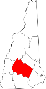 Map of New Hampshire highlighting Merrimack County | |
| Towns | ||
| CDPs | ||
| Other unincorporated communities | ||
| Footnotes | ‡This populated place also has portions in an adjacent county or counties | |
| Authority control |
|
|---|