Beaver Falls, Pennsylvania
Beaver Falls is a city in Beaver County, Pennsylvania, United States. The population was 8,987 at the 2010 census. It is located 31 miles (50 km) northwest of Pittsburgh, and on the Beaver River, six miles (9 km) north of its confluence with the Ohio River.
Beaver Falls, Pennsylvania | |
|---|---|
| City of Beaver Falls | |
 View of Beaver Falls, from the borough of New Brighton. | |
| Nicknames: Birthplace of College Basketball | |
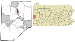 Location in Beaver County and the U.S. state of Pennsylvania. | |
| Coordinates: 40°45′32″N 80°19′11″W | |
| Country | United States |
| State | Pennsylvania |
| County | Beaver County |
| Incorporated | November 9, 1868 (borough) |
| December 3, 1928 (city) | |
| Government | |
| • Mayor | George Quay (interim) |
| Area | |
| • Total | 2.35 sq mi (6.09 km2) |
| • Land | 2.13 sq mi (5.51 km2) |
| • Water | 0.22 sq mi (0.58 km2) |
| Population (2010) | |
| • Total | 8,987 |
| • Estimate (2018)[2] | 8,387 |
| • Density | 3,986.37/sq mi (1,539.17/km2) |
| Time zone | UTC−5 (EST) |
| • Summer (DST) | UTC−4 (EDT) |
| ZIP Code | 15010 |
| FIPS code | 42-04792 |
| Website | City website |
History
Originally called Brighton, Beaver Falls was chartered as a borough in 1868. It adopted the commission form of government in 1913.
| Historical population | |||
|---|---|---|---|
| Census | Pop. | %± | |
| 1870 | 3,112 | — | |
| 1880 | 5,104 | 64.0% | |
| 1890 | 9,735 | 90.7% | |
| 1900 | 10,054 | 3.3% | |
| 1910 | 12,191 | 21.3% | |
| 1920 | 12,802 | 5.0% | |
| 1930 | 17,147 | 33.9% | |
| 1940 | 17,098 | −0.3% | |
| 1950 | 17,375 | 1.6% | |
| 1960 | 16,240 | −6.5% | |
| 1970 | 14,635 | −9.9% | |
| 1980 | 12,525 | −14.4% | |
| 1990 | 10,687 | −14.7% | |
| 2000 | 9,920 | −7.2% | |
| 2010 | 8,987 | −9.4% | |
| Est. 2018 | 8,387 | [2] | −6.7% |
| U.S. Decennial Census[3] | |||
In the 1870s, Beaver Falls was home to a Chinatown and had up to 225 Chinese residents, brought in to work at Beaver Falls Cutlery Company.[4][5]
Travelers would often stop in Beaver Falls while traversing Western Pennsylvania, since there were many modes of transportation through the area (railroad, highway, canal). The city was also linked to Ellwood City in 1914 by the Pittsburgh, Harmony, Butler and New Castle Railway, an interurban trolley line. The line closed on 15 June 1931.
The city is best known in fiction as the setting of the television situation comedy Mr. Belvedere.
On May 31, 1985, an F3 tornado hit just north of the city as it went across northern portions of Beaver County, as part of the 1985 United States-Canadian tornado outbreak.[6] Geneva College is located in the College Hill neighborhood on the north side of the city. The world's first recorded college basketball game occurred in the city on April 8, 1893 when the intramural team from Geneva College defeated the New Brighton YMCA.
The population declined nearly 50% between 1940 and 2000, which is attributed mostly to its central location in the Rust Belt.[7][8][9] Several manufacturing plants provided significant employment for residents in the twentieth century. Like most rust belt cities, Beaver Falls has suffered a fair amount of economic malaise due to the decline in the steel-making capacity in the region.
Geography
Beaver Falls is located at 40°45′32″N 80°19′11″W (40.758865, -80.319737).[10]
According to the United States Census Bureau, the city has a total area of 2.3 square miles (6.0 km2), of which 2.1 square miles (5.4 km2) is land and 0.2 square miles (0.5 km2) (7.02%) is water.
Surrounding and adjacent neighborhoods
Beaver Falls has five land borders: Patterson Heights and Patterson Township to the southwest, White Township to the west, West Mayfield to the northwest, and Big Beaver to the north.
Across the Beaver River to the east, Beaver Falls runs adjacent with North Sewickley to the northeast, Eastvale and Daugherty Township to the east (the former with the only connector via Eastvale Bridge), and New Brighton to the southeast.
Demographics
As of the census[11] of 2000, there were 9,920 people, 3,798 households, and 2,259 families residing in the city. The population density was 4,681.6 people per square mile (1,806.7/km2). There were 4,380 housing units at an average density of 2,067.1 per square mile (797.7/km2). The racial makeup of the city was 78.82% White, 17.53% African American, 0.13% Native American, 0.62% Asian, 0.02% Pacific Islander, 0.50% from other races, and 2.37% from two or more races. Hispanic or Latino of any race were 1.06% of the population.
There were 3,798 households, out of which 26.9% had children under the age of 18 living with them, 36.6% were married couples living together, 19.1% had a female householder with no husband present, and 40.5% were non-families. 35.3% of all households were made up of individuals, and 16.7% had someone living alone who was 65 years of age or older. The average household size was 2.31 and the average family size was 3.00.
In the city, the population was spread out, with 21.9% under the age of 18, 16.7% from 18 to 24, 25.1% from 25 to 44, 18.8% from 45 to 64, and 17.5% who were 65 years of age or older. The median age was 35 years. For every 100 females, there were 84.3 males. For every 100 females age 18 and over, there were 79.1 males.
The median income for a household in the city was $26,344, and the median income for a family was $30,405. Males had a median income of $31,151 versus $22,243 for females. The per capita income for the city was $13,808. About 19.8% of families and 22.5% of the population were below the poverty line, including 29.8% of those under age 18 and 12.4% of those age 65 or over.
Notable people
- Adam K. Bert, stamp collector and dealer
- Ralph E. Chambers, amusement ride engineer
- Papa John Creach, musician, violinist who played with Jefferson Airplane and Hot Tuna
- Jack Damaska, MLB player
- Dave Dameshek, NFL analyst/writer, TV comedy writer, podcast host, and radio personality
- Ernest Kline, Lieutenant Governor of Pennsylvania from 1971 to 1979
- Tony Lip, actor, The Sopranos, Donnie Brasco
- Joe Lonnett, MLB player and coach
- Paul McKee, professional football player
- Thomas Midgley, Jr., inventor of lead for gasoline, and chlorofluorocarbons
- Jim Mutscheller, tight end, Baltimore Colts, 1954-1961
- Joe Namath, Hall of Fame AFL and NFL quarterback[12]
- Harry Traver, engineer and roller coaster designer
- Tom Tribone, energy entrepreneur, founder and CEO of Guggenheim Global Infrastructure Company
- Joe Walton, college and professional football coach
- Candy Young, former hold of National High School Record in 100 meters. Sports Illustrated High School Athlete of the Year for 1979.
Neighborhoods
- College Hill
- Morado
- Mount Washington
- Lower End
- Downtown
- Pleasantview
- Riverview
Education
- Beaver County Christian High School
- Big Beaver Falls Area School District
- Divine Mercy Academy
- Geneva College
Sites of interest
- Beaver River Trail, a paved rail trail that runs over the former Pittsburgh and Lake Erie Railroad right-of-way along the Beaver River.
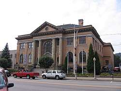
- Carnegie Free Library of Beaver Falls, the first public library in Beaver County. The library was established in 1903 and was given a $50,000 grant from Andrew Carnegie, making the structure a Carnegie library. The building is on the National Register of Historic Places.
- Reeves Field is the playing field for the Beaver Falls Fighting Tigers and the Geneva College Golden Tornadoes football teams.
Transportation
Air
The closest airport to the city is Beaver County Airport. Though located in Allegheny County, Pittsburgh International Airport is within close proximity of Beaver Falls, and is easily accessible by way of I-376 (former PA 60).[13]
Highways
I-376 is located just west of the city, and is accessible from Beaver Falls via PA 51, PA 551, and PA 588. PA 18 is the main road through Beaver Falls, and becomes the city's Main Street when going through downtown. PA 65 is located southeast of Beaver Falls in New Brighton. Plus, the Pennsylvania Turnpike is located just north of Beaver Falls, providing access to the entire state. PA 251 is a small highway located on the western edge of the city in the borough of West Mayfield.
Rail
Major freight haulers CSX Transportation and the Norfolk Southern Railway (NS) both have mainlines running through Beaver Falls. NS also has a subsidiary line along the east side of Beaver River. Amtrak's Capitol Limited passes through the city via NS tracks without stopping. Amtrak's Broadway Limited and successor Three Rivers also passed through town until 2005.
Waterways
Though not used for transporting goods and materials, the Beaver River is a navigable waterway for boating.
References
- "2017 U.S. Gazetteer Files". United States Census Bureau. Retrieved Mar 24, 2019.
- "Population and Housing Unit Estimates". Retrieved August 18, 2019.
- "Census of Population and Housing". Census.gov. Retrieved June 4, 2015.
- "Chinese Workers In Beaver Falls". Archived from the original on 2011-06-09.
- Anon (1993). "Gone but not forgotten: the Beaver Falls Cutlery Company". Industrious Beaver Falls. Darlington, Pennsylvania: Beaver County Industrial Museum. This is based on Anon (1992). "The history and lore of Beaver Co.: the Chinese in Beaver Falls 1872". The Beaver Countian Vol III no.1. Beaver Falls, Pennsylvania. pp. 1–3.
- Britten, Kenneth, Beaver Falls Gem of Beaver County, Arcadia Publishing, 2002, ISBN 0-7385-2382-8.
- "Archived copy". Archived from the original on 2010-03-27. Retrieved 2017-12-07.CS1 maint: archived copy as title (link)
- "Archived copy". Archived from the original on 2010-05-05. Retrieved 2017-12-07.CS1 maint: archived copy as title (link)
- https://www.census.gov/prod/cen1990/cph2/cph-2-1-1.pdf
- "US Gazetteer files: 2010, 2000, and 1990". United States Census Bureau. 2011-02-12. Retrieved 2011-04-23.
- "U.S. Census website". United States Census Bureau. Retrieved 2008-01-31.
- Wilson, Earl (Nov 27, 1969). "Small Towns Have Produced Many Big Stars". The Milwaukee Sentinel. pp. A33. Retrieved 22 May 2015.
- Highway now I-376 from Monroeville to Mercer
External links
| Wikimedia Commons has media related to Beaver Falls, Pennsylvania. |
| Wikivoyage has a travel guide for Beaver Falls. |
- City website

- "Beaver Falls". New International Encyclopedia. 1905.
- . Collier's New Encyclopedia. 1921.
- . . 1914.
Pittsburgh metropolitan area | ||
|---|---|---|
| Counties |  Map of the Pittsburgh Tri-State with green counties in the metropolitan area and yellow counties in the combined area. | |
| Major cities | ||
| Cities and towns 15k–50k (in 2010) | ||
| Airports | ||
| Topics | ||
| ||
Municipalities and communities of Beaver County, Pennsylvania, United States | ||
|---|---|---|
| Cities | 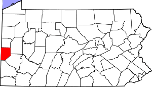 | |
| Boroughs |
| |
| Townships | ||
| Unincorporated communities | ||
| Footnotes | ‡This populated place also has portions in an adjacent county or counties | |
| Authority control |
|
|---|