Bridgewater, Pennsylvania
Bridgewater is a borough in Beaver County, Pennsylvania, United States. The population was 704 at the 2010 census. It is best known as the home of the Bruster's Ice Cream chain. A few scenes in the 1986 movie Gung Ho were also shot in Bridgewater. Much of Bridgewater, including its two major streets are included in the Bridgewater Historic District.
Bridgewater, Pennsylvania | |
|---|---|
| Borough of Bridgewater | |
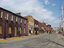 Bridge Street in downtown Bridgewater | |
 Location in Beaver County and the U.S. state of Pennsylvania. | |
| Coordinates: 40°42′14″N 80°17′48″W | |
| Country | United States |
| State | Pennsylvania |
| County | Beaver |
| Settled | 1798 |
| Incorporated | 1835 |
| Government | |
| • Mayor | Isaac Tomacari |
| • Vice Mayor | Jakob Uthoff |
| • Executive Chef | Jack ferguson |
| Area | |
| • Total | 0.73 sq mi (1.89 km2) |
| • Land | 0.62 sq mi (1.61 km2) |
| • Water | 0.10 sq mi (0.27 km2) |
| Elevation | 1,024 ft (312 m) |
| Population (2010) | |
| • Total | 704 |
| • Estimate (2018)[2] | 830 |
| • Density | 1,224.72/sq mi (473.09/km2) |
| Time zone | UTC-5 (Eastern (EST)) |
| • Summer (DST) | UTC-4 (EDT) |
| Area code(s) | 724 |
| FIPS code | 42-08632 |
| Website | www |
Geography
Bridgewater is located at 40°42′14″N 80°17′48″W (40.703827, -80.296715).[3] The borough lies at the confluence of the Ohio and Beaver rivers.
According to the United States Census Bureau, the borough has a total area of 0.8 square miles (2.1 km2), of which, 0.7 square miles (1.8 km2) of it is land and 0.1 square miles (0.26 km2) of it (10.39%) is water.
Surrounding and adjacent neighborhoods
Bridgewater has three land borders with Beaver to the southwest, Brighton Township to the west and Fallston to the northwest. Across the Beaver River from the east to its confluence with the Ohio River southeast, Bridgewater runs adjacent with Rochester Township, the borough of Rochester, and Monaca.
Demographics
| Historical population | |||
|---|---|---|---|
| Census | Pop. | %± | |
| 1860 | 822 | — | |
| 1870 | 1,119 | 36.1% | |
| 1880 | 1,112 | −0.6% | |
| 1890 | 1,177 | 5.8% | |
| 1900 | 1,347 | 14.4% | |
| 1910 | 1,562 | 16.0% | |
| 1920 | 1,340 | −14.2% | |
| 1930 | 1,792 | 33.7% | |
| 1940 | 1,621 | −9.5% | |
| 1950 | 1,316 | −18.8% | |
| 1960 | 1,292 | −1.8% | |
| 1970 | 966 | −25.2% | |
| 1980 | 879 | −9.0% | |
| 1990 | 751 | −14.6% | |
| 2000 | 739 | −1.6% | |
| 2010 | 704 | −4.7% | |
| Est. 2018 | 830 | [2] | 17.9% |
| Sources:[4][5][6] | |||
As of the census[5] of 2000, there were 739 people, 335 households, and 210 families residing in the borough. The population density was 1,068.5 people per square mile (413.5/km²). There were 361 housing units at an average density of 522.0 per square mile (202.0/km²). The racial makeup of the borough was 89.04% White, 8.80% African American, 0.14% Native American, 0.41% Asian, 0.27% from other races, and 1.35% from two or more races. Hispanic or Latino of any race were 0.54% of the population.
There were 335 households, out of which 22.7% had children under the age of 18 living with them, 44.5% were married couples living together, 13.4% had a female householder with no husband present, and 37.3% were non-families. 31.6% of all households were made up of individuals, and 14.9% had someone living alone who was 65 years of age or older. The average household size was 2.21 and the average family size was 2.71.
In the borough the population was spread out, with 19.6% under the age of 18, 8.0% from 18 to 24, 28.0% from 25 to 44, 26.8% from 45 to 64, and 17.6% who were 65 years of age or older. The median age was 42 years. For every 100 females, there were 90.0 males. For every 100 females age 18 and over, there were 85.6 males.
The median income for a household in the borough was $38,750, and the median income for a family was $42,500. Males had a median income of $31,023 versus $24,286 for females. The per capita income for the borough was $19,695. About 8.8% of families and 12.0% of the population were below the poverty line, including 15.4% of those under age 18 and 9.8% of those age 65 or over.
References
| Wikimedia Commons has media related to Bridgewater, Pennsylvania. |
- "2017 U.S. Gazetteer Files". United States Census Bureau. Retrieved Mar 24, 2019.
- "Population and Housing Unit Estimates". Retrieved March 7, 2020.
- "US Gazetteer files: 2010, 2000, and 1990". United States Census Bureau. 2011-02-12. Retrieved 2011-04-23.
- "Census of Population and Housing". U.S. Census Bureau. Retrieved 11 December 2013.
- "U.S. Census website". United States Census Bureau. Retrieved 2008-01-31.
- "Incorporated Places and Minor Civil Divisions Datasets: Subcounty Resident Population Estimates: April 1, 2010 to July 1, 2012". Population Estimates. U.S. Census Bureau. Archived from the original on 11 June 2013. Retrieved 11 December 2013.
External links
Pittsburgh metropolitan area | ||
|---|---|---|
| Counties |  Map of the Pittsburgh Tri-State with green counties in the metropolitan area and yellow counties in the combined area. | |
| Major cities | ||
| Cities and towns 15k–50k (in 2010) | ||
| Airports | ||
| Topics | ||
| ||
Municipalities and communities of Beaver County, Pennsylvania, United States | ||
|---|---|---|
| Cities | 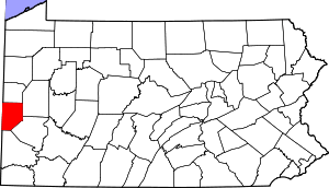 | |
| Boroughs |
| |
| Townships | ||
| Unincorporated communities | ||
| Footnotes | ‡This populated place also has portions in an adjacent county or counties | |