Unity Township, Westmoreland County, Pennsylvania
Unity Township is a township in Westmoreland County, Pennsylvania, United States. The population was 22,607 at the 2010 census.
Unity Township, Pennsylvania | |
|---|---|
 Kingston House (1815) National Register of Historic Places | |
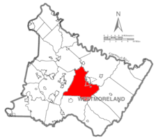 Map of Westmoreland County, Pennsylvania Highlighting Unity Township | |
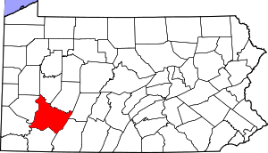 Map of Pennsylvania highlighting Westmoreland County | |
| Country | United States |
| State | Pennsylvania |
| County | Westmoreland |
| Settled | 1760 |
| Incorporated | September 23, 1789 |
| Area | |
| • Total | 67.58 sq mi (175.02 km2) |
| • Land | 67.44 sq mi (174.67 km2) |
| • Water | 0.14 sq mi (0.35 km2) |
| Population (2010) | |
| • Total | 22,607 |
| • Estimate (2018)[2] | 21,910 |
| • Density | 331.02/sq mi (127.81/km2) |
| Time zone | UTC-5 (Eastern (EST)) |
| • Summer (DST) | UTC-4 (EDT) |
| Area code(s) | 724 |
| FIPS code | 42-129-78656 |
| Website | http://www.unitytownship.org |
History
Unity Township was incorporated on September 23, 1789. Initial records show settlement going back to 1760. Residents of Mount Pleasant Township petitioned the court to establish a new township around the area next to the Loyalhanna creek, based on the inconvenience of the size of the existing township, and the need to travel long distances to conduct township affairs. One of the oldest communities in the township was Youngstown, an important stop in the wagon and stagecoach era, ca. 1818–1852, which became a separate borough in 1831.[3]
The Kingston House and St. Vincent Archabbey Gristmill are listed on the National Register of Historic Places.[4]
Geography
According to the United States Census Bureau, the township has a total area of 67.3 square miles (174.2 km²), of which, 67.1 square miles (173.8 km²) is land and 0.2 square miles (0.4 km²) (0.24%) is water.
The township contains the following communities: Baggaley, Beatty, Carney, Denison, Donohoe, Dorothy, Dry Ridge, George's Station, Greenwald, Hostetter, Humphreys, Lawson Heights, Lloydsville, Lycippus, Manito, Marguerite, Mutual, Old Crabtree, Pleasant Unity, and Whitney.
Demographics
| Historical population | |||
|---|---|---|---|
| Census | Pop. | %± | |
| 1940 | 10,994 | — | |
| 1950 | 12,392 | 12.7% | |
| 1960 | 15,519 | 25.2% | |
| 1970 | 18,419 | 18.7% | |
| 1980 | 19,976 | 8.5% | |
| 1990 | 20,109 | 0.7% | |
| 2000 | 21,137 | 5.1% | |
| 2010 | 22,607 | 7.0% | |
| Est. 2018 | 21,910 | [2] | −3.1% |
| U.S. Decennial Census[5][6][7] | |||
At the 2000 census there were 21,137 people, 7,963 households, and 5,773 families living in the township. The population density was 315.0 people per square mile (121.6/km²). There were 8,372 housing units at an average density of 124.8/sq mi (48.2/km²). The racial makeup of the township was 98.12% White, 0.32% African American, 0.13% Native American, 0.86% Asian, 0.02% Pacific Islander, 0.15% from other races, and 0.40% from two or more races. Hispanic or Latino people of any race were 0.42%.[8]
Of the 7,963 households 29.5% had children under the age of 18 living with them, 61.9% were married couples living together, 7.5% had a female householder with no husband present, and 27.5% were non-families. 24.6% of households were one person and 11.4% were one person aged 65 or older. The average household size was 2.48 and the average family size was 2.95.
The age distribution was 21.5% under the age of 18, 9.1% from 18 to 24, 26.4% from 25 to 44, 25.8% from 45 to 64, and 17.2% 65 or older. The median age was 41 years. For every 100 females, there were 96.7 males. For every 100 females age 18 and over, there were 93.6 males.
The median household income was $40,585 and the median family income was $49,593. Males had a median income of $37,907 versus $26,164 for females. The per capita income for the township was $21,116. About 5.8% of families and 8.7% of the population were below the poverty line, including 10.0% of those under age 18 and 9.8% of those age 65 or over.
Notable people
- John Latta (1836-1913), 1st Lieutenant Governor of Pennsylvania
References
- "2016 U.S. Gazetteer Files". United States Census Bureau. Retrieved Aug 14, 2017.
- Bureau, U. S. Census. "U.S. Census website". United States Census Bureau. US Census Bureau. Retrieved 1 December 2019.
- History of Westmoreland County Volume 1, Chapter 41
- "National Register Information System". National Register of Historic Places. National Park Service. July 9, 2010.
- "Census of Population and Housing". Census.gov. Retrieved June 4, 2016.
- https://www.census.gov/prod/cen1990/cph2/cph-2-40.pdf
- https://www2.census.gov/prod2/decennial/documents/17216604v1p40ch02.pdf
- "U.S. Census website". United States Census Bureau. Retrieved 2008-01-31.
External links
Pittsburgh metropolitan area | ||
|---|---|---|
| Counties |  Map of the Pittsburgh Tri-State with green counties in the metropolitan area and yellow counties in the combined area. | |
| Major cities | ||
| Cities and towns 15k–50k (in 2010) | ||
| Airports | ||
| Topics | ||
| ||