Vermillion River (South Dakota)
| Vermillion River | |
| River | |
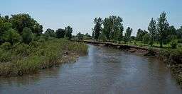 Vermillion River between Parker and Chancellor | |
| Country | United States |
|---|---|
| State | South Dakota |
| Cities | Vermillion, SD, Centerville, SD |
| Source | Confluence of the East Fork Vermillion River and West Fork Vermillion River |
| - location | Parker Township in Turner County, near Parker, South Dakota |
| - coordinates | 43°23′39″N 97°04′08″W / 43.394083°N 97.069006°W |
| Mouth | Missouri River |
| - location | Fairview Township in Clay County, near Vermillion, South Dakota |
| - coordinates | 42°43′59″N 96°53′25″W / 42.733007°N 96.890335°WCoordinates: 42°43′59″N 96°53′25″W / 42.733007°N 96.890335°W |
| Length | 96 mi (154 km) |
| Basin | 2,180 sq mi (5,646 km2) |
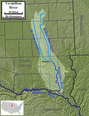 The course and watershed of the Vermillion River. | |
The Vermillion River is a tributary of the Missouri River, 96 miles (154 km) long,[1] in eastern South Dakota in the United States. The origin of the river name is Waséoyuze Lakota for "place where Vermilion is obtained".[2]
It is formed by the confluence of the East Fork Vermillion River and West Fork Vermillion River. The East Fork, approximately 103 miles (166 km) long,[1] rises in Lake Whitewood in Kingsbury County on the Coteau des Prairies. The West Fork, approximately 108 miles (174 km) long,[1] rises in Miner County. Both forks flow south, roughly parallel, joining east of Parker. The combined river flows south and joins the Missouri east of the James River Highlands[3] and 5 miles (8 km) south of Vermillion. Its tributaries include White Stone Creek and Baptist Creek. The Vermillion River drains about 2,180 square miles (5,600 km2) of the southwestern edge of the Coteau des Prairies. Approximately once per 3.5 years, the Vermillion runs dry.[3]
The Vermillion is a north-south river situated between the Big Sioux River and James River.[3]
See also
References
- 1 2 3 U.S. Geological Survey. National Hydrography Dataset high-resolution flowline data. The National Map Archived 2012-04-05 at WebCite, accessed March 30, 2011
- ↑ Federal Writers' Project (1940). South Dakota place-names, v.3. University of South Dakota. p. 6.
- 1 2 3 Hogan, Edward Patrick; Fouberg, Erin Hogan (2001). The Geography of South Dakota (Third ed.). Sioux Falls, SD: The Center for Western Studies – Augustana College. ISBN 0-931170-79-6.
| Lists |  | |
|---|---|---|
| Geography | ||
| Native American tribes | ||
| History | ||
| Engineering | ||
| Parks and preserves | ||
| ||
