Takhar Province
| Takhar Persian: تخار Pashto: تخار ولايت | |
|---|---|
| Province | |
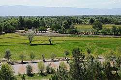 View from atop a hill in Khawajah Bahawuddin, Takhar Province, Afghanistan. | |
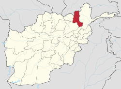 Map of Afghanistan with Takhar highlighted | |
| Coordinates (Capital): 36°42′N 69°48′E / 36.7°N 69.8°ECoordinates: 36°42′N 69°48′E / 36.7°N 69.8°E | |
| Country | Afghanistan |
| Capital | Taloqan |
| Government | |
| • Governor | Dr.fazlullah Mujaddedi |
| Area | |
| • Total | 12,333 km2 (4,762 sq mi) |
| Population (2012)[1] | |
| • Total | 933,700 |
| • Density | 76/km2 (200/sq mi) |
| Time zone | UTC+4:30 |
| Main languages | Dari (Afghan Persian) |
Takhar (Persian: تخار; Pashto: تخار ولايت) is one of the thirty-four provinces of Afghanistan, located in the northeast of the country next to Tajikistan. It is surrounded by Badakhshan in the east, Panjshir in the south, and Baghlan and Kunduz in the west. The city of Taloqan serves as its capital.
The province contains about 16 districts, over 1,000 villages, and approximately 933,700 people,[1] which is multi-ethnic and mostly a rural society.[2]
History
Early history
7th to 16th centuries
16th to 20th centuries
Between the early 16th century and the mid-18th century, the territory was ruled by the Khanate of Bukhara.
It was given to Ahmad Shah Durrani by Murad Beg of Bukhara after a treaty of friendship was reached in or about 1750, and became part of the Durrani Empire. It was ruled by the Durranis followed by the Barakzai dynasty, and was untouched by the British during the three Anglo-Afghan wars that were fought in the 19th and early 20th centuries.
1964–2001
It was established in 1964 when Qataghan Province was divided into three provinces: Baghlan, Kunduz and Takhar. During the 1980s Soviet–Afghan War, the area fell under the influence of Rabbani and Ahmad Shah Massoud. It was controlled by the Northern Alliance in the 1990s. It experienced some fighting between the Northern Alliance and the Taliban forces. Takhar holds notoriety as the location where Mujahideen Commander Ahmad Shah Massoud was assassinated on 9 September 2001 by suspected al-Qaeda agents.
2001–2015
International Security Assistance Force (ISAF) took over security responsibility of the area in the early 2000s, which was led by Germany. The province also began to see some developments and the establishment of Afghan National Security Forces (ANSF). In a small incident in July 2008, the Afghan National Police killed Mullah Usman when several armed Taliban militants under his command raided a police checkpoint in the Kalafgan district. This was the first time since the fall of Taliban regime in 2001 that the Taliban insurgents engaged police in this province. Mullah Usman was the most senior Taliban commander in the northeast region of Afghanistan, according to the Afghan Interior Ministry.[3]
In May 2009, Taliban insurgents fighting Afghan government attacked the Baharak district in Takhar province.[4] A bomb attack on 28 May 2011 killed Mohammed Daud Daud and injured Governor Taqwa. Several German soldiers and Afghans were also killed.[5]
In April 2012, the water supply at the Rostaq district's school for girls was poisoned by unknown insurgents, sickening at least 140 Afghan schoolgirls and teachers ranging in age from 14 to 30, causing them to be hospitalized and some to partially lose consciousness, though there have been no deaths so far.[6]
2015 earthquake
On October 26, the 7.5 Mw Hindu Kush earthquake shook northern Afghanistan with a maximum Mercalli intensity of VIII (Severe). This earthquake destroyed almost 30,000 homes, left several hundred dead, and more than 1,700 injured.[7]
Politics and governance
The current governor is Abdul Jabbar Taqwa. The border with neighboring Tajikistan are monitored by the Afghan Border Police (ABP). All law enforcement activities throughout the province are handled by the Afghan National Police (ANP). A provincial Police Chief is assigned to lead both the ANP and the ABP. The Police Chief represents the Ministry of the Interior in Kabul. The ANP is backed by the military, including the NATO-led forces.
Demographics
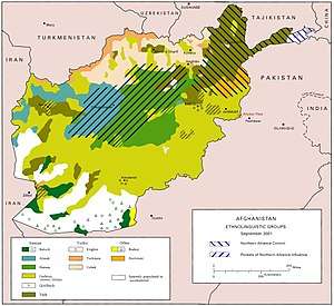
The population of the province is about 933,700,[1] which is mostly tribal and a rural society. The main inhabitants of Takhar province are Tajiks at 60% and Uzbeks at 35%. The remainders are Pashtun, Hazara, Pashai, Kho and Turkmen. There are also a population of Kuchis (nomads) whose numbers vary in different seasons.
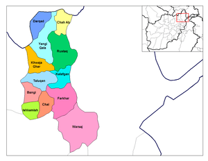
District information
| District | Capital | Population[8] | Area | Number of villages and ethnic groups | ||||||
|---|---|---|---|---|---|---|---|---|---|---|
| Baharak | 40,902 | 231 km2 | 74 villages 65% tajik 35% Uzbek.[9] | |||||||
| Bangi | 28,197 | 566 km2 | 59 villages.[10] | |||||||
| Chah Ab | 64,151 | 764 km2 | 63 villages 85% Tajik.[11] | |||||||
| Chal | 24,596 | 330.8 km2 | 58 villages. Uzbek, Tajik, Pashtun, Hazara, Pashai and Gujjar.[12] | |||||||
| Darqad | 25,771 | 393 km2 | 34 villages 80% tajik.[13] | |||||||
| Dashti Qala | 35,347 | 280 km2 | 49 villages. 60% Uzbek, 35% Tajik, 5% Pashtun.[14] | |||||||
| Farkhar | 79,864 | 1,214 km2 | 75 villages 95% Tajik.[15] | |||||||
| Hazar Sumuch | 9,774 | 309 km2 | 28 villages.[16] | |||||||
| Ishkamish | 51,153 | 806 km2 | 103 villages. 55% Tajik, 35% Uzbek and 10% Pashtun.[17] | |||||||
| Kalafgan | 28,122 | 479 km2 | 42 villages 85% Tajik.[18] | |||||||
| Khawajah Bahawodin | 26,280 | 178.2 km2 | 25 villages. Uzbek, Tajik, Pashtun.[19] | |||||||
| Khwaja Ghar | 44,909 | 402 km2 | 62 villages.[20] | |||||||
| Namak Ab | 11,563 | 584 km2 | 28 villages.[21] | |||||||
| Rustaq | 248,780 | 1,939 km2 | 179 villages. 45%Uzbek, 40%Tajik, 15% Baloch.[22] | |||||||
| Taluqan | Taluqan | 194,471 | 85% Tajik- | Warsaj | 33,506 | 2705.3 km2 | 94 villages. 80%Tajik,10%Uzbek,Gujjar, Pashai and Hazara.[23] | |||
| Yangi Qala | 39,398 | 247 km2 | 64 villages.[24] |
Economy
Agriculture and mining are the main industries of the province. Takhar has coal reserves of fairly good quality which are being exploited by hand in some villages and sold in the region. The local population considers gold the most relevant resource for the Province. Gold is being washed in Takhar River, and about 2 kg are being transported to the specific weekly markets in the city of Taloqan. Also the city is a main source of construction materials like: loam, sand, and different types of stones. Takhar province is known for its salt mountains and you can find large deposits of fine salt in the region. The Takcha Khanna salt mine is one of the growing number of salt supplier, for the population of Takhar and northern Afghanistan. While the mines offer economic opportunities in the region, the availability of iodized salt considerably reduces the prevalence of health problems related to iodine deficiency.
See also
Footnotes
- 1 2 3 "Settled Population of Takhar province by Civil Division, Urban, Rural and Sex-2012-13" (PDF). Retrieved 2012-10-20.
- ↑ "Takhar provincial profile" (PDF). Archived from the original (PDF) on 1 December 2017. Retrieved 22 May 2012.
- ↑ "Takhar police kill Taliban commander"
- ↑ "Taliban attack district in NE Afghanistan". Military-world.net. 24 May 2009. Retrieved 22 May 2012.
- ↑ "Three German soldiers die in Afghan attack". Thepeninsulaqatar.com. 29 May 2011. Archived from the original on 31 May 2011. Retrieved 22 May 2012.
- ↑ Masoud Popalzai, CNN (17 April 2012). "Extremists poison schoolgirls' water, Afghan officials say". CNN. Retrieved 22 May 2012.
- ↑ USGS. "M7.5 - 45km E of Farkhar, Afghanistan". United States Geological Survey.
- ↑ "Takhar Province". Government of Afghanistan and United Nations Development Programme (UNDP). Ministry of Rural Rehabilitation and Development. Retrieved 2012-11-05.
- ↑ Baharak District
- ↑ Bangi District
- ↑ Chah Ab District
- ↑ Chal District
- ↑ Darqad District
- ↑ Dasht e Qala Agha
- ↑ Farkhar District
- ↑ Hazar Smoch District
- ↑ Eshkamish District
- ↑ Baharak District
- ↑ Khwaja Bahawodin District
- ↑ Khwaja Ghar
- ↑ Namak Ab District
- ↑ Rostaq Agha
- ↑ Warsaj District
- ↑ Yangi Qala
External links
| Wikimedia Commons has media related to Takhar Province. |
- Naval Postgraduate School - Takhar Province
- Ministry of Rural Rehabilitation and Development - Takhar Province
- Defense Video & Imagery Distribution System - Takhar Province
- http://www.trekearth.com/gallery/Asia/Afghanistan/East/Takhar/ (pictures of Takhar province)
Places adjacent to Takhar Province | ||||||||||
|---|---|---|---|---|---|---|---|---|---|---|
| ||||||||||