Andar District
| Andar اندړ ولسوالۍ | |
|---|---|
| District | |
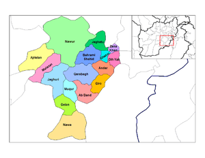 | |
 Andar Location within Afghanistan | |
| Coordinates: 33°19′05″N 68°27′00″E / 33.318121°N 68.450131°E | |
| Country |
|
| Province | Ghazni Province |
| Population (2009)[1] | |
| • Total | 88,300 |
Andar (Pashto: اندړ ولسوالۍ) is one of the eastern districts of Ghazni Province in Afghanistan.[2] The population has been estimated at 88,300, all Pashtun. The district center is Miray. The district also contains the town of Sardeh Band on its edge near the border with Paktika Province.
The main source of income in the district is agriculture, which has been seriously affected by drought. Most roads are bad and unpaved. The main highway between Ghazni city and Paktika province is paved, though damaged from attacks. There is 1 clinic, 1 hospital, 17 primary schools and 1 high school.[2]
The district contains a large water reservoir, created by the Sardeh Band Dam located near the border of Andar and Paktika.
See also
References
- ↑ "Afghanistan Election Data". National Democratic Institute. Retrieved 16 October 2015.
- 1 2 "District Profile" (PDF). UNHCR. Retrieved 16 October 2015.
External links
- Map of Andar District (PDF)
This article is issued from
Wikipedia.
The text is licensed under Creative Commons - Attribution - Sharealike.
Additional terms may apply for the media files.