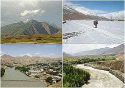
Badakhshan Province
| Badakhshan Province ولایت بدخشان | |
|---|---|
| Province | |
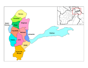
 Different districts of Badakhshan Province | |
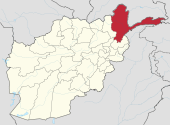 Map of Afghanistan with Badakhshan highlighted | |
| Coordinates: 38°0′N 71°0′E / 38.000°N 71.000°ECoordinates: 38°0′N 71°0′E / 38.000°N 71.000°E | |
| Country |
|
| Capital | Fayzabad |
| Government | |
| • Governor | Ahmad Faisal Begzad |
| Area[1] | |
| • Total | 44,059 km2 (17,011 sq mi) |
| Population (2012)[2] | |
| • Total | 904,700 |
| • Density | 21/km2 (53/sq mi) |
| Time zone | UTC+4:30 |
| ISO 3166 code | AF-BDS |
| Main languages | Dari, Khowar, Kyrgyz, Shughni, Munji, Ishkashimi, Wakhi |
Badakhshan Province (Pashto: د بدخشان ولایت Badaxšān wilāyat and Persian: ولایت بدخشان, translit. Velâyat-e Badakhšân) is one of the 34 provinces of Afghanistan, located in the farthest northeastern part of the country between Tajikistan and northern Pakistan. It shares a 56.5-mile (91 km) border with China.
It is part of a broader historical Badakhshan region. The province contains 22 to 28 districts, over 1,200 villages, and approximately 904,700 people.[2] Feyzabad serves as the provincial capital.
Geography
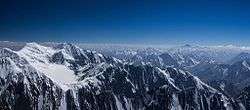
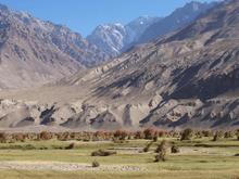
Badakhshan is primarily bordered by Gorno-Badakhshan Autonomous Province and Khatlon Province in Tajikistan to the north and east. In the east of the province a long spur called the Wakhan Corridor extends above northern Pakistan's Chitral and Northern Areas to a border with China. The province has a total area of 44,059 square kilometres (17,011 sq mi), most of which is occupied by the Hindu Kush and Pamir mountain ranges.
Badakhshan was a stopover on the ancient Silk Road trading path, and China has shown great interest in the province after the fall of the Taliban, helping to reconstruct roads and infrastructure.
According to the World Wildlife Fund, Badakhshan contains temperate grasslands, savannas, and shrublands, as well as Gissaro-Alai open woodlands along the Pamir River. Common plants found in these areas include pistachio, almond, walnut, apple, juniper, and sagebrush.
Montane grasslands and shrublands are existent in the province, with the Hindu Kush alpine meadow in the high mountains in the northern and southwestern regions.
The Wakhan corridor contains two montane grassland and shrubland regions: the Karakoram-West Tibetan Plateau alpine steppe and in the Pamir Mountains and Kuh-e Safed Khers in Darwaz region.
South of Fayzabad the terrain becomes dominated by deserts and xeric shrublands. Common vegetation includes thorny bushes, zizyphus, acacia, and Amygdatus. Paropamisus xeric woodlands can be found in the province's northwestern and central areas. Common vegetation includes almond, pistachio, willows, and sea-buckthorn.
History
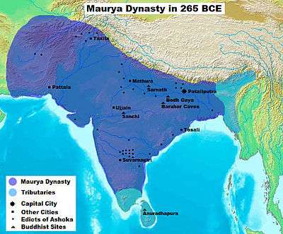
Badakhshan province under Mauryan Empire rule
The Badakhshan province territory fell to the Maurya Empire, which was led by Chandragupta Maurya. The Mauryas introduced Hinduism and Buddhism to the region and were planning to capture more territory of Central Asia until they faced local Greco-Bactrian forces. Seleucus is said to have reached a peace treaty with Chandragupta by giving control of the territory south of the Hindu Kush to the Mauryas by intermarriage and 500 elephants.
Alexander took these away from the Indo-Aryans and established settlements of his own, but Seleucus Nicator gave them to Sandrocottus (Chandragupta), upon terms of intermarriage and of receiving in exchange 500 elephants.[3]
— Strabo, 64 BC–24 AD
Some time after, as he was going to war with the generals of Alexander, a wild elephant of great bulk presented itself before him of its own accord, and, as if tamed down to gentleness, took him on its back, and became his guide in the war, and conspicuous in fields of battle. Sandrocottus, having thus acquired a throne, was in possession of India, when Seleucus was laying the foundations of his future greatness; who, after making a league with him, and settling his affairs in the east, proceeded to join in the war against Antigonus. As soon as the forces, therefore, of all the confederates were united, a battle was fought, in which Antigonus was slain, and his son Demetrius put to flight.[4]
Having consolidated power in the northwest, Chandragupta pushed east towards the Nanda Empire. Afghanistan's significant ancient tangible and intangible Buddhist heritage is recorded through wide-ranging archeological finds, including religious and artistic remnants. Buddhist doctrines are reported to have reached as far as Balkh even during the life of the Buddha (563 BCE to 483 BCE), as recorded by Husang Tsang.
In this context a legend recorded by Husang Tsang refers to the first two lay disciples of Buddha, Trapusa and Bhallika responsible for introducing Buddhism in that country. Originally these two were merchants of the kingdom of Balhika, as the name Bhalluka or Bhallika probably suggests the association of one with that country. They had gone to India for trade and had happened to be at Bodhgaya when the Buddha had just attained enlightenment.[5]
The area has a long history like the rest of Afghanistan, dating to its conquering by the Achaemenid Empire and beyond. Badakhshan etymologically derives from the Middle Persian word badaxš, an official title. The suffix of the name, -ān, means the region belonged to someone with the title badaxš.[6]
The territory was ruled by the Uzbek Khanate of Bukhara between the early 16th century and the mid-18th century. It was given to Ahmad Shah Durrani by Murad Beg of Bukhara after a treaty of friendship was reached in or about 1750 and became part of the Durrani Empire. It was ruled by the Durranis followed by the Barakzai dynasty, and was untouched by the British during the three Anglo-Afghan wars that were fought in the 19th and 20th centuries. It remained peaceful for about 100 years until the 1980s Soviet–Afghan War at which point the Mujahideen began a rebellion against the central Afghan government.
During the 1990s, much of the area was controlled by forces loyal to Burhanuddin Rabbani and Ahmad Shah Massoud.[7] Badakhshan was the only province that the Taliban did not conquer during their rule from 1996 to 2001. However, during the course of the wars a non-Taliban Islamic emirate was established in Badakhshan by Mawlawi Shariqi, paralleling the Islamic Revolutionary State of Afghanistan in neighboring Nuristan. Burhanuddin Rabbani, a Badakhshan native, and Ahmad Shah Massoud were the last remnants of the anti-Taliban Northern Alliance during the peak of Taliban control in 2001.
2015 earthquake
On 26 October, the 7.5 Mw Hindu Kush earthquake shook northern Afghanistan with a maximum Mercalli intensity of VIII (Severe). This earthquake destroyed almost 30,000 homes, left several hundred dead, and more than 1,700 injured.[8]
Politics and governance
The current Governor of the province is Shah Waliullah Adeeb.[9] His predecessors were Munshi Abdul Majid and Baz Mohammad Ahmadi. The borders with neighboring Tajikistan, China, and Pakistan are monitored by the Afghan Border Police (ABP). All law enforcement activities throughout the province are handled by the Afghan National Police (ANP). A provincial Police Chief is assigned to lead both the ANP and the ABP. The Police Chief represents the Ministry of the Interior in Kabul. The ANP is backed by the military, including the NATO-led forces.
Fayzabad, the capital of Badakhshan province, sits on the Kokcha River and has an approximate population of 50,000. The chief commercial and administrative center of northeast Afghanistan and the Pamir region, Fayzabad also has rice and flour mills.
Transportation
Fayzabad Airport serves the province with regular direct flights to Kabul.
Healthcare
The percentage of households with clean drinking water increased from 13% in 2005 to 21% in 2011.[10] The percentage of births attended to by a skilled birth attendant increased from 1.5% in 2003 to 2% in 2011.[10]
Education
The overall literacy rate (6+ years of age) fell from 31% in 2005 to 26% in 2011.[10] The overall net enrolment rate (6–13 years of age) increased from 46% in 2005 to 68% in 2011.[10]
Economy
Despite massive mineral reserves, Badakhshan is one of the most destitute areas in the world. Opium poppy growing is the only real source of income in the province and Badakhshan has one of the highest rates of maternal mortality in the world, due to the complete lack of health infrastructure, inaccessible locations, and bitter winters of the province. BORNA Institute of Higher Education being the first private university located on the bank of Kokcha river.
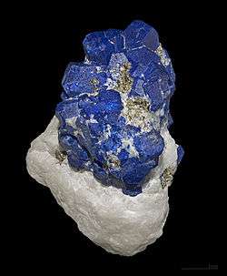
Lapis lazuli has been mined in the Sar-e-Sang mines, located in the Kuran wa Munjan District of Badakhshan, for over 6,000 years. The mines were the largest and most well-known source in ancient times.[11][12] Most recent mining activity has focused on lapis lazuli, with the proceeds from the lapis mines being used to fund Northern Alliance troops, and before that, anti-Soviet Mujahideen fighters.[13] Recent geological surveys have indicated the location of other gemstone deposits, in particular rubies and emeralds.[14] It is estimated that the mines at Kuran wa Munjan District hold up to 1,290 tonnes of azure (lapis lazuli).[15] Exploitation of this mineral wealth could be key to the region's prosperity.[14]
Sport
The province is represented in Afghan domestic cricket competitions by the Badakhshan Province cricket team BORNA Cricket Club which belong to BORNA Institute of Higher Education is coming up with its own team and will be groomed by the experts in the field of cricket.
Demography
The population of the province is about 904,700, which is a multi-ethnic rural society.[2] Dari-speaking, Tajiks make up the majority followed by Uzbeks, Hazaras, Pashtuns, Kyrgyz, Qizilbash, and others.[16] There are also speakers of the following Pamiri languages: Shughni, Munji, Ishkashimi, and Wakhi.
The inhabitants of the province are mostly Sunni Muslims, although there are also some Ismaili Shias.
Historical population estimates for Badakhshan province are as follows:[17]
Districts
| District | Capital | Population[18] | Area | Number of villages and ethnic groups |
|---|---|---|---|---|
| Arghanj Khwa | 12,000 | |||
| Argo | 83,999 | 1,032 km2 | 145 villages. 60% Uzbek and 40% Tajik.[19] | |
| Baharak | Baharak | 33,012 | 328 km2 | 51 villages. 60% Tajik, 35% Uzbek, and 5% Pashtun.[20] |
| Darayim | 72,000 | 570 km2 | 101 villages. 80% Tajik, 15% Uzbek and 5% Hazara.[21] | |
| Fayzabad | Fayzabad | 96,826 | 514 km2 | 175 villages. 97% Tajik and 3% others.[22] |
| Ishkashim | Ishkashim | 12,566 | 1,123 km2 | 43 villages.[23] |
| Jurm | 51,714 | 1286 km2 | 75 villages. 95% Tajik and 5% Uzbek.[24] | |
| Khash | 15,436 | 264 km2 | 21 villages. 70% Tajik, 20% Uzbek, and 10% Mughol and Baloch.[25] | |
| Khwahan | Khwahan | 27,000 | 80 km2 | 46 villages. Tajik.[26] |
| Kishim | Mashhad | 71,262 | 264 km2 | 100 villages. 60% Tajik, 37% Uzbek, 10% Baluch, 1% Hazara and 1% Bayat.[27] |
| Kohistan | 13 Villages Tajik | |||
| Kuf Ab | Qal`eh-ye Kuf | 16,000 | ||
| Keran wa Menjan | Keran wa Menjan | 8,084 | 1,588 km2 | 42 villages. 100% Tajik.[28] |
| Maimay | Jamarj-e Bala | 12,000 | ||
| Nusay | Nusay | 31,195 | 4,589 km2 | 16 villages. Tajik.[29] |
| Raghistan | Ziraki | 37,000 | 25 villages Tajik | |
| Shahri Buzurg | Shahri Buzurg | 80,000 | 956 km2 | 74 villages.[30] |
| Sheghnan | Shughnan | 27,750 | 3528 km2 | 28 villages. Khowar, Tajik and Qizilbash.[31] |
| Shekay | Jarf | 27,000 | 1,700 km2 | 38 villages. Tajik, etc.[32] |
| Shuhada | 26,430 | 1,521 km2 | 62 villages. 99% Tajik and 1% others.[33] | |
| Tagab | 22,000 | |||
| Tishkan | 26,850 | 812 km2 | 57 villages. 70% Tajik, 20% Hazara and 10% Uzbek.[34] | |
| Wakhan | 14,657 | 10,953 km2 | 110 villages. Tajik, Kuchi people during winter.[35] | |
| Warduj | 16,609 | 929 km2 | 45 villages. 90% Tajik and 10% Uzbek.[36] | |
| Yaftali Sufla | 60,000 | 605 km2 | 93 villages. 60% Tajik and 40% Uzbek.[37] | |
| Yamgan | 30,000 | 1,779 km2 | 39 villages. 100% Tajik[38] | |
| Yawan | 27,000 | |||
| Zebak | Zebak | 26,430 | 1,521 km2 | 62 villages. 99% Tajik and 1% others.[39] |
Notable people from Badakhshan
- Zulmai Mujadidi, Member of Parliament representing Badakhshan
- Burhanuddin Rabbani, leader of the Jamiat-e Islami political party and former president of Afghanistan
- Tahir Badakhshi, political activist
- Latif Pedram, political activist and candidate for Afghanistan's presidency
- Nasratullah Nasrat, Afghan cricketer
- Fawzia Koofi, noted Afghan women's rights activist, member of Parliament and 2014 presidential candidate
- Ustad Ahmad Lahauri, Chief architect of the Taj Mahal
See also
References
- ↑ "Statoids".
- 1 2 3 "Settled Population of Badakhshan province by Civil Division, Urban, Rural and Sex-2012-13" (PDF). Retrieved 2012-10-20.
- ↑ Nancy Hatch Dupree / Aḥmad ʻAlī Kuhzād (1972). "An Historical Guide to Kabul - The Name". American International School of Kabul. Archived from the original on 30 August 2010. Retrieved 2010-09-18.
- ↑ Historiarum Philippicarum libri XLIV, XV.4.19
- ↑ Puri, Baij Nath (1987). Buddhism in central Asia. Motilal Banarsidass Publ. p. 352. ISBN 81-208-0372-8. Retrieved 2010-11-03.
- ↑ Eilers, W. "BADAKŠĀN". Encyclopædia Iranica (Online ed.). United States: Columbia University. Archived from the original on 2 January 2009. Retrieved 21 August 2018.
- ↑ Conflict analysis: Baharak district, Badakhshan province, http://www.cmi.no/pdf/?file=/afghanistan/doc/ACF280.pdf
- ↑ USGS. "M7.5 - 45km E of Farkhar, Afghanistan". United States Geological Survey.
- ↑ "Database – Who is who in Afghanistan?". Afghan-bios.info. Retrieved 22 May 2012.
- 1 2 3 4 Archive, Civil Military Fusion Centre, https://www.cimicweb.org/AfghanistanProvincialMap/Pages/Badakhshan.aspx
- ↑ Deer, William A.; Howie, Robert A, and Zussman, Joseph (1963) "Lapis lazuli" Rock-Forming Minerals Longman, London, OCLC 61975619
- ↑ Lapis lazuli was also found in the Urals Mountains in Russia. Deer et al. above
- ↑ Entekhabi-Fard, Camelia (15 October 2002). "Northern Alliance Veteran Hopes Emeralds Are Key Part of Afghanistan's Economic Recovery". Eurasia Insight. Archived from the original on 8 July 2007. Retrieved 20 August 2007.
- 1 2 "Afghanistan's gemstones" (PDF). Planet Earth. Winter 2006. Archived (PDF) from the original on 11 September 2008. Retrieved 20 August 2008.
- ↑ Hamdard, Hidayatullah (20 January 2014). "Karzai assigns team to probe azure mine issue". Pajhwok Afghan News. Retrieved 2014-01-20.
- ↑ "1 Badakhshan". Rkabuli.20m.com. Retrieved 22 May 2012.
- ↑ Andrew Ross (ross@undpafg.org.pk. "Afghanistan Geographic & Thematic Layers". Fao.org. Retrieved 22 May 2012.
- ↑ "Badakhshan Province". Government of Afghanistan and United Nations Development Programme (UNDP). Ministry of Rural Rehabilitation and Development. Retrieved 2012-10-30.
- ↑ Argo Centre
- ↑ Baharak District
- ↑ Draim District
- ↑ Faiz Abad District (in Dari)
- ↑ Ishkashim District
- ↑ Jerm District
- ↑ Khash District
- ↑ Khowahan District
- ↑ Kishm District
- ↑ Keran Wa Menjan District
- ↑ Nusay District
- ↑ Shahr-e-Bozorg District
- ↑ Sheghnan District
- ↑ Shekay District
- ↑ Shuhada District
- ↑ Tushkan District
- ↑ Wakhan District
- ↑ Wardoj District
- ↑ Yaftal Sofla District
- ↑ Yamgan District
- ↑ Zibak District
Further reading
- Burhanuddin Kushkaki. Rāhnamā-yi Qaṭaghan va Badakhshān. Kabul: Vizarat-i Ḥarbiyah, 1923.
- Jan-Heeren Grevemeyer: Herrschaft, Raub und Gegenseitigkeit: Die politische Geschichte Badakhshans 1500–1883, Otto Harrassowitz, Wiesbaden 1982
- Wolfgang Holzwarth: Segmentation und Staatsbildung in Afghanistan: Traditionale sozio-politische Organisation in Badakhshan, Wakhan und Sheghnan In: Berliner Institut für vergleichende Sozialforschung [Red.: Kurt Greussing u. Jan-Heeren Grevemeyer] (Hrsg.): Revolution in Iran und Afghanistan – mardom nameh – Jahrbuch zur Geschichte und Gesellschaft des Mittleren Orients Syndikat, Frankfurt am Main 1980, ISBN 3-8108-0147-X.
External links
| Wikimedia Commons has media related to Badakhshan Province. |
Places adjacent to Badakhshan Province | |
|---|---|
| Districts | | |
|---|---|---|
| Populated places |
| |
| Buildings and structures | ||
| Other | ||
| ||