Paktika Province
| Paktika پکتیکا | |
|---|---|
| Province | |
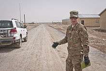
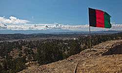 The Afghan national flag overlooks a valley from an observation post at Paktika province in Afghanistan | |
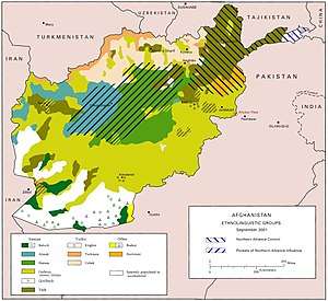
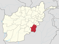 Map of Afghanistan with Paktika highlighted | |
| Coordinates (Capital): 32°30′N 68°48′E / 32.5°N 68.8°ECoordinates: 32°30′N 68°48′E / 32.5°N 68.8°E | |
| Country |
|
| Capital | Sharana |
| Largest city | Urgun |
| Government | |
| • Governor | Ilyas Wahdat |
| Area | |
| • Total | 19,482 km2 (7,522 sq mi) |
| Population (2015)[1] | |
| • Total | 434,742 |
| • Density | 22/km2 (58/sq mi) |
| Time zone | UTC+4:30 |
| ISO 3166 code | AF-PKA |
| Main languages | Pashto |
Paktika (Pashto: پکتیکا) is one of the 34 provinces of Afghanistan, located in the eastern part of the country. Forming part of the larger Loya Paktia region, Paktika has a population of about 413,800,[2] mostly ethnic Pashtuns. The town of Sharana serves as the provincial capital, while the most populous city is Urgun.
Geography
Paktika sits adjacent to Durand Line border between Pakistan and Afghanistan. It is bordered by the Khost and Paktia provinces to the north. The western border is shared with the provinces of Ghazni and Zabul. The South Waziristan and North Waziristan agencies are to the east of Paktika, while Zhob District of the Balochistan province of Pakistan borders it the southeast.
Paktika, like many other areas of Afghanistan, has been severely deforested. This has been a cause of devastating floods in recent years. The province is mainly hilly and interspersed with seasonal river valleys. In the north, the terrain gains elevation and becomes more rugged. In the west, the Rowd-e Lurah River originates in the mountainous Omna District and flows southwest to the Ghazni Province, forming a shallow river valley that dominates the topography in the Zarghun Shar, Jani Khel, and Dila Districts. The terrain in Omna becomes more hilly further east in proximity to Pakistan. The sparsely populated southern districts are also hilly, with descending elevation towards the south and west.
The Gomal River, which has a varied flow depending on season, runs from its origin in the mountains of the Sar Hawza District and flows south, before turning southeast to the Pakistani border, forming the broad river valley that defines the topography of the Gomal District, before flowing east through Pakistan and eventually running to the powerful Indus River.
History
Paktika is the southernmost part of a historical region known as Greater Paktia (Pashto: لویه پکتیا, Loya Paktia), that was once a unified province including Paktia, Khost and parts of Ghazni and Logar. The tribes that reside in this area were mentioned by the Greek historian Herodotus, who called them the "Pactyans" as early as the 1st millennium BCE.
In the 1970s, the provincial capital of the largely undeveloped and remote province of Paktika was moved from the town of Urgun to Sharana due to its proximity with the main highway, connecting it to the larger cities and commercial centres of Kabul, Ghazni and Kandahar.
Paktika was the site of many battles during the Soviet occupation of the country and the lawless years that followed.
The Siege of Urgun took place between 1983 and 1984.
Recent history
As one of the most remote provinces in Afghanistan and an area that saw much devastation in previous years, Paktika suffers from a severe lack of critical infrastructure. Reconstruction in the province after the fall of the Taliban has been slow compared to that in nearby provinces such as Khost and Zabul. This is primarily due to the remoteness of the region and repeated attacks on aid workers and NATO forces.
In June 2004, members of the Utah and Iowa National Guard helped Army Reserve Civil Affairs Soldiers from Oregon establish a Provincial Reconstruction Team base in Sharana, the provincial capital, to lead the development effort. The first full contingent of eight Civil Affairs Soldiers from the U.S. Army Reserve's 450th Civil Affairs Battalion (Airborne), based in Riverdale Park, Maryland, arrived in September 2004.
In an article from Time, the U.S. base was described as:
- "The U.S. firebase looks like a Wild West cavalry fort, ringed with coils of razor wire. A U.S. flag ripples above the 3-ft.-thick mud walls, and in the watchtower a guard scans the expanse of forested ridges, rising to 9,000 ft., that mark the border. When there's trouble, it usually comes from that direction." [3]
The Shkin firebase is composed of special operations forces. They target, and are constant targets themselves for the Al-Qa'ida and Taliban fighters who launch frequent strikes from nearby Pakistan. The area is unforgiving, where the enemy can hide at close range while remaining invisible. A hunter can become prey very quickly. As U.S. Army Colonel Rodney Davis puts it, "Shkin is the evilest place in Afghanistan." [3]
While the province hasn't witnessed the outright fighting in the last few years that has affected provinces like Helmand, there is a constant low level of tribal violence, accompanied by criminal and Taliban activity. The last serious fighting in the province took place in 2004, amid reports that then-Governor Muhammad Ali Jalali was collaborating with Taliban forces, and that the Taliban had effectively annexed eastern portions of the province. Jalali and many of his allied officials, were replaced and U.S. Special Forces were dispatched to fight the Taliban while the Pakistani forces fought with the Taliban's allies in neighbouring South Waziristan.
On 1 November 2004, a civil affairs convoy was ambushed near Surobi, between the Shkin firebase and Orgun-E. U.S. Army Spc. James Kearney, a turret gunner, died of a head shot from a sniper, which initiated the ambush. After countless RPGs, PKM rounds and an IED, two vehicles were destroyed and three other Soldiers were wounded.[4] The Provincial Reconstruction Team base was named Camp Kearney on 21 November 2004 to honor the sacrifice of Spc. James Kearney.[5]
On Jun 18, 2008 in the Ziruk District Governor's compound, 2 members of the Provincial Reconstruction Team, HMN Mark Retmier and CM1 Ross Toles, were killed due to rocket attacks. The Mess hall on Forward Operating Base Sharana is named after CM1 Toles and the hospital is named after HMN Retmier.
Kearney Base became the nucleus of what is now Forward Operating Base Sharana.
On July 4th, 2009 combat outpost Zerok in East Paktika Province was attacked. The Haqqani network insurgents attacked the COP using mortars, accurate heavy machine gun fire, RPG fire, recoils rifles, and a 5000lbs Jingle Truck VBIED that destroyed the outposts radio communication. The accurate enemy indirect fire from their mortars set the US mortar pit on fire, and killed two Able Company, 3rd Battalion 509th parachute Infantry regiment mortarmen, PFC Casillas and PFC Fairbairn. They were both returning fire on the 120mm mortar. After the VBIED went off, multiple insurgents began maneuvering towards the outpost, some getting within 100 meters of the cop. Because the enemy was advancing so close to the outpost and the threat of being over ran was there, the request for CAS was called in, but because of the DUSTWUN(large scale search) for PFC Bergdahl, (who went AWOL after abandoning his post only 100km away from COP Zerok), air support was delayed. After intense fighting the US Paratroopers suppressed and killed most of the enemy, eventually gunships arrived and JDAMs were dropped on enemy targets. There is a youtube and Hulu video titled "attack on the 4th of July", which documents the story of the July 4th, 2009, attack on Combat Outpost Zerok in Afghanistan and the men of Able Company 3-509. Emphasis is on the dedication, teamwork and camaraderie of the men of Able Company. Features real battle footage.
In 2010 the 101st Rakkasan air assault took over Cop Zerok. There is a 60 minutes tv special documenting them at COP Zerok. You can find the video on youtube under "A relentless enemy".
In late July 2011, foreign troops and Afghan special forces killed more than 50 insurgents during an operation in eastern Paktika to clear a training camp the Haqqani network used for foreign fighters, NATO said. Disenfranchised insurgents told security forces where the camp was located, the coalition said.[6]
In November 2011, an estimated 60 to 70 Taliban insurgents were killed in an abortive attack on a joint Afghan-ISAF base in the Margha area of Barmal. No international troops were killed or injured in the incident. It is believed the insurgents crossed over from neighboring FATA and Balochistan of Pakistan. In a separate incident the governor of Sar Hawza district died in the same month after his vehicle struck a roadside bomb.[7]
In the spring of 2012 the 172nd Infantry Brigade opened the first Afghan National Army/ US Joint Artillery Fire Base in the Orgun District.
Eight civilians including a pregnant woman and a baby died when Polish soldiers shelled the village of Nangar Khel, where a wedding celebration was taking place. Seven Polish soldiers have been charged with war crimes for allegedly opening fire in revenge.
U.S. Army PFC Bowe Bergdahl was captured by enemy forces on July 4, 2009 near the town of Yahya Khel. This incident occurred as a result of the Soldier leaving his unit without permission and venturing into the local area. He was the last know American P.O.W of the Afghanistan conflict. He was freed in a prisoner trade on May 31, 2014.[8][9]
Politics and governance
The current governor of the province is Aminullah Shariq.[10] The town of Sharana serves as the provincial capital. All law enforcement activities throughout the province are controlled by the Afghan National Police (ANP). Paktika's border with neighboring Federally Administered Tribal Areas (FATA) of Pakistan is under the control of the Afghan Border Police (ABP). The border area in this province is often used by Taliban insurgents entering from Pakistan. The provincial police chief represents the Ministry of the Interior in Kabul. The ANP is backed by other Afghan National Security Forces (ANSF), including the National Directorate of Security (NDS) and NATO-led forces.
New official Sulaimankhel Social Tribal Council licensed and registered with The Afghanistan Ministry of Justice and The Ministry of Borders and Tribal Affairs has been established in Kabul Afghanistan. Sulaimankhel Tribal Council has many provincial offices throughout Afghanistan including one office in Shrana, Paktika. Ayoub Khalikyar Sulaimankhel is the president of Sulaimankhel Tribal Council of Afghanistan.
Senior Haqqani Network leader, Sangeen Zadran was the Taliban shadow governor of Paktita Province until 5 September 2013, when he was killed in a US drone strike. His brother Bilal Zadran replaced him in the position.[11]
Transportation
As of May 2014, Paktika Province had regularly scheduled passenger flights to Kabul from Sharana Airstrip. The province's development is considered "backwards" compared to the rest of the country but Engineer Hafizullah, head of provincial public works department claimed in 2013 that in the past few years, 154-kilometers roads had been constructed with 70 km having been constructed in 2013 alone.[12]
Demographics
The population of Paktika province is 413,800,[2] which is a multi-ethnic tribal society. According to the Naval Postgraduate School, the ethnic groups of the province are as follows: Pashtun, Tajik, Arab, Pashai, and other various minority groups.[13] Other sources mention that ethnic Pashtuns make up around 96% of Paktika's population.[14] Around 15,000 people (1.8%) are ethnic Uzbeks; and about 5,000 people speak some other languages.[14] These are most probably Hazaras or Baloch. There is also a small Tajik community in Urgun.[15][16][17]


The overwhelming majority of Paktika's population (around 99%) live in rural districts. The capital city, Sharana, has around 54,400 inhabitants. The majority of Pakikta's Districts have between 25,000 and 55,000 inhabitants. Only two districts, Nika and Turwo have less than 20,000 inhabitants, with a little more than 15,000 apiece. Two of the least mountainous districts, Urgun and neighboring Barmal have nearly 90,000 inhabitants each. There are around 115,000 households, with eight members apiece, in the Province.
Most of the Population is Sunni Muslim, and belongs to the Hanafi School.
Some tribes in Paktika may be pastoral.
Tribes
In Afghanistan the Ghilji are scattered all over the country but mainly settled around the regions between Zabul and Kabul provinces.The Afghan province of Paktika is considered to be a heartland of the Ghilji tribe. Ghilji sub-tribes in Paktika include the Kharoti, especially in the Sar Hawza and Urgon districts, the Andar and the largest single Ghilji sub-tribe, the Sulaimankhel, who are the majority in northern and western areas of Paktika such as; Katawaz. After the great Ghilji rebellion in 1885–1886, led by Alam Khan Nasher, many members of the Ghilji tribe, such as; the Kharoti sub-tribe and particularly the Nasher clan were exiled from Loya Paktia (Paktia, Paktika and Khost) to Kunduz in the north by Amir Abdur Rahman Khan due to political reasons. They are predominantly a nomadic group unlike the Durranis who are usually found in permanent settlements.The Ghilji mostly work as herdsmen as well as construction workers and in other jobs that allow them to travel. Often possessing great mechanical aptitude, the Ghilji nonetheless have an extremely low literacy rate hovering below 10% in Afghanistan. The Ghilji regularly cross over between Afghanistan and Pakistan often being exempted from customs due to the acceptance of their nomadic traditions by officials from both countries. Population estimates vary, but they are most likely around 20% to 25% of the population of Afghanistan and probably number over 9 million in Afghanistan alone with 4 million or more found in The main Pashtun tribes that live in Paktika are:
- Ghilji (Bettani)
- Ibrahimzai
- Alizai
- Sulaimanzai
- Jalalzai
- Alikhel
- Boran
- Suleimankhel
- Toran
- Katawazy
- Kharoti
- Andar
- Karlanri
The Sulaimankhel are one of the largest sub-tribes of the Ghilji Pashtuns. The Sulaimankhel tribe is mainly located in the southern and eastern portions of Afghanistan; however, they also have a strong presence in the northern and western portions of Afghanistan. The second largest Sulaimankhel population is located in Pakistan. Not only are they located in the province of Baluchistan and the North-West Frontier Province, but also located in Karachi and other parts of Pakistan.
The Kharoti and Sulaimankhel tribes are traditional rivals, although they co-exist together in several districts. The larger, influential and more powerful Sulaimankhel have historically had the upper hand in this rivalry. The Wazir and Kharoti are sometimes involved in a land dispute in Barmal District.
Districts
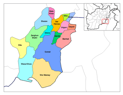
| District | Capital | Population [14] | Area[18] | Notes |
|---|---|---|---|---|
| Barmal | Angur Ada | 88,028 | Incloudes Barmal, Shkin & Margha Cities. | |
| Dila | 50,203 | |||
| Gayan | 42,495 | |||
| Gomal | Shkin | 64,275 | ||
| Janikhel | 35,251 | Created in 2004 within Zarghun Shar District | ||
| Mata Khan | 19,758 | |||
| Nika | 15,103 | |||
| Omna | 25,690 | |||
| Sar Hawza | 36,236 | |||
| Surobi | 48,291 | |||
| Sharana | Sharana | 54,416 | ||
| Terwa | 15,332 | Created in 2004 within Waza Khwa District | ||
| Urgun | Urgun | 89,718 | ||
| Wazakhwa | Wazakhwa | 50,818 | Sub-divided in 2004 | |
| Wor Mamay | 30,135 | |||
| Yahyakhel | 30,161 | Created in 2004 within Zarghun Shar District | ||
| Yusufkhel | 32,648 | Created in 2004 within Zarghun Shar District | ||
| Zarghun Shar | Zarghun Shar | 38,024 | Sub-divided in 2004 | |
| Zerok | Zerok | 43,190 |
See also
References
- ↑ Afghanistan at GeoHive
- 1 2 "Settled Population of Paktika province by Civil Division, Urban, Rural and Sex-2012-13" (PDF). Islamic Republic of Afghanistan: Central Statistics Organization. Retrieved 2013-06-09.
- 1 2 "Battle in "the Evilest Place"". Time. 27 October 2003. Retrieved 21 May 2010.
- ↑ "NEWS ADVISORY, November 1, 2004". Iowanationalguard.com. Retrieved 2011-10-23.
- ↑ "DefendAmerica News - New Provincial Reconstruction Team Opens in Paktika Province". Defendamerica.mil. Archived from the original on 2014-01-05. Retrieved 2011-10-23.
- ↑ Michelle Nichols (July 22, 2011). "NATO kills 50 fighters, clears Afghan training camp". Reuters. Retrieved July 23, 2011.
- ↑ AFP (November 9, 2011). "Up to 70 Taliban dead as Afghan attack thwarted". AFP. Retrieved November 9, 2011.
- ↑ "Taliban claim captured U.S. solider [sic] has converted to Islam and is teaching its fighters bomb-making skills". Daily Mail. London. 22 August 2010.
- ↑ NY Post, American's last P.O.W of the Afghanistan, By Michael Gartland, May 31, 2014
- ↑ http://www.pajhwok.com/en/2015/09/27/16-killed-44-injured-paktika-playground-blast
- ↑ Rehman, Zia Ur (13 September 2013) 'A great blow' thefridaytimes.com
- ↑ Paktika needs more projects to develop infrastructure: Residents, By: Ali Mohammad Nazari, Date: 2013-09-09, http://www.elections.pajhwok.com/en/content/paktika-needs-more-projects-develop-infrastructure-residents
- ↑ "Paktika Province" (PDF). Program for Culture & Conflict Studies. Naval Postgraduate School. Retrieved 2013-06-09.
- 1 2 3 Paktika provincial profile, June 2004, profile compiled by the National Area-Based Development Programme (NABDP) of the Ministry of Rural Rehabilitation and Development (MRRD)
- ↑ The population is 88% Pashtun, with a Tajik minority living mainly in the district center and controlling a large proportion of the district's economy and service provision
- ↑ 'Destruction is Rebuilding, or: Fare thee well, population-centric COIN,' Afghanistan Analysts Network. Aan-afghanistan.com (2011-03-18). Retrieved on 2013-07-12.
- ↑ "Afghanistan's Dirty War: Why the Most Feared Man in Bermal District Is a U.S. Ally". Time. 4 October 2011.
- ↑ Andrew Ross (ross@undpafg.org.pk. "Afghanistan Geographic & Thematic Layers". Fao.org. Retrieved 2011-10-23.
External links
| Wikimedia Commons has media related to Paktika Province. |
| |||||
| Participants |
| ||||
| Conflicts |
| ||||
| See also |
| ||||
Places adjacent to Paktika Province | |
|---|---|