Daykundi Province
| Daykundi دایکندی | |
|---|---|
| Province | |
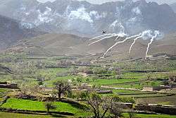 An AH-64 Apache helicopter shoots flares over a valley while operating in support members of the 8th Commando Kandak and coalition special operations forces during a firefight near Nawa Garay village, Kajran district in April 2012. | |
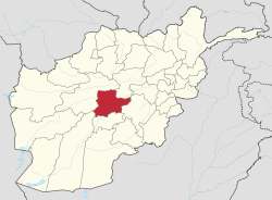 Map of Afghanistan with Daikundi highlighted | |
| Coordinates: 33°45′N 66°15′E / 33.75°N 66.25°ECoordinates: 33°45′N 66°15′E / 33.75°N 66.25°E | |
| Country | Afghanistan |
| Established | 2004 |
| Capital | Nili |
| Government | |
| • Governor | Mahmoud Baligh |
| Area[1] | |
| • Total | 18,088 km2 (6,984 sq mi) |
| Population (2012)[2] | |
| • Total | 723,980 |
| Time zone | UTC+4:30 |
| ISO 3166 code | AF-DAY |
| Main languages | Dari (Hazaragi dialect) |
| Website |
daikundi |
Daykundi (Persian: دایکندی, Pashto: دایکنډي) sometimes spelled as Daikundi, Dāykondī, Daikondi or Daykundi, is one of the thirty-four provinces of Afghanistan, located in the central part of the country. It has a population of about 723,980,[2] which is a Hazara Province.
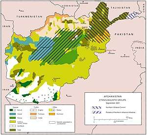
Daykundi Province falls into the traditionally ethnic Hazara region known as the Hazarajat and the provincial capital is Nili. It is surrounded by Ghor in the northwest, Bamyan in the northeast, Ghazni in the southeast, Urozgan in the south, and Helmand Province in west.
Daykundi
Daykundi was established on March 28, 2004, when it was created from the isolated Hazara-dominated northern districts of neighboring Oruzgan province.
Development and security
Since the establishment of the province nearly a decade ago, the province has extended its security having the best of all provinces and has increased education surpassing even Kabul in the number of those passing university entrance exams. The province, began its transition in December 2011, maintains its own security through the Afghan police and military.[3]
While the Government of Afghanistan, NGOs, the United Nations, and NATO's ISAF forces have had little involvement in reconstruction in the province, there have been some initiatives. Following heavy rainfall and flooding in February 2007 the United Nations Assistance Mission for Afghanistan (UNAMA) opened a sub-office in the province[4] and Oxfam, one of the few NGOs operating in the province, described UNAMA's input into coordinating flood relief as impressive.[4]
In November 2007 a World Food Programme convoy carrying mixed food aid was forced to abandon its mission due to security concerns and Afghanistan's Interior Ministry confirmed that Taliban insurgents had infiltrated the southern district of Kajran in a bid to destabilise the province. On 11 November 2007 Afghan forces launched a military operation to drive out the insurgents.[5]
The United States began building new government institutions in the province. The insurgency problem and shortage of food continued until 2012. Several government officials have warned in October 2012 that "If the government or NGOs (non-governmental organization) do not address the situation with proper assistances, Daikundi would witness many deaths this winter."[6] In the meantime, a rebel leader along with his 150 fighters joined the government-initiated peace drive in Nili, capital of Daikundi province.[7]
Governance
In June 2015, Masooma Muradi was chosen as the Governor of Daikundi Province. The provincial Police Chief, who leads the regular Afghan National Police (ANP), is responsible for all law enforcement activities. The Police Chief represents the Ministry of the Interior in Kabull.
Demographics
The total population of Daykundi province is estimated to around 723,980,[2] which is multi-ethnic and mostly a rural tribal society. The ethnic Hazaras make up 90% of the total population of the province followed by Pashtuns at 6.5%, Balochs 3.5%. All the inhabitants follow Islam, with Shi'as the majority and Sunnis as the minority. Languages spoken in the province include Dari, Hazaragi, Pashto, and Balochi.
Districts
| District | Capital | Population[8] | Area | Number of villages and ethnic groups |
|---|---|---|---|---|
| Ashtarlay | 88,340 | 1,360 km2 | 343 villages. 100% Hazara.[8] | |
| Kijran | 73,800 | 1,886 km2 | Mostly Balochs[8] | |
| Khedir | 83,400 | 1,583 km2 | 294 villages. 100% Hazara.[8] | |
| Kitti | 64,900 | 887 km2 | 196 villages. 36% Hazara and Baloch, 10% Mika, 18% Mir, 14% Zerger, 10% Sadat (Sayyid), and 17% others.[8] | |
| Miramor | 88,400 | 2,363 km2 | 326 villages. 100% Hazara.[8] | |
| Nili | Nili | 95,340 | 445 km2 | 165 villages. 100% Hazara.[9] |
| Sang Takh | 95,000 | 1,945 km2 | 100% Hazara.[8] | |
| Shahristan | 72,450 | 1,963 km2 | 290 villages. 100% Hazara.[8] |
Economy
Agriculture is the main industry of the province. It is well known for its high-quality almonds, which are distributed throughout Afghanistan.
See also
References
- ↑ "Statoids". Retrieved 2018-07-19.
- 1 2 3 "Settled Population of Daykundi province by Civil Division , Urban, Rural and Sex-2012-13" (PDF). Central Statistics Office Afghanistan (CSO). Retrieved 2018-07-19.
- ↑ "Daykundi province reaches out for unity across Afghanistan | ISAF - International Security Assistance Force". Isaf.nato.int. Archived from the original on 2012-04-29. Retrieved 2012-07-30.
- 1 2 "UN Office For The Coordination of Humanitarian Affairs : UNAMA Facing New Humanitarian Challenges". Irinnews.org. 2007-05-28. Retrieved 2018-07-19.
- ↑ John Pike (2007-11-14). "UN-OCHA Integrated Regional Information Networks : Insecurity Stops Food Aid to a Day Kundi District". Globalsecurity.org. Retrieved 2018-07-19.
- ↑ Hadi Ghafari (2012-10-28). "Winter food crisis looms over Daikundi". Afghanistan Analysts Network. Retrieved 2018-07-19.
- ↑ Hadi Ghafari (2012-10-30). "150 rebels in Daikundi give up insurgency". Pajhwok Afghan News. Retrieved 2018-07-19.
- 1 2 3 4 5 6 7 8 "DaiKundi Province". Government of Afghanistan and United Nations Development Programme (UNDP). Ministry of Rural Rehabilitation and Development. Retrieved 2012-10-28.
- ↑ Nili District
External links
| Wikimedia Commons has media related to Daykundi Province. |
Places adjacent to Daykundi Province | ||||||||||
|---|---|---|---|---|---|---|---|---|---|---|
| ||||||||||