Farsi District
| Fares | |
|---|---|
| District | |
 Fares Location within Afghanistan | |
| Coordinates: 33°41′51″N 63°05′32″E / 33.6974°N 63.0921°E | |
| Country |
|
| Province | Herat Province |
| Population (2012)[1] | |
| • Total | 29,800 |
Farsi (Persian: ولایت فارسی) is a district the west of Herat Province, Afghanistan. It borders on Obe District to the north, Adraskan District to the west, Shindand District to the south and Ghor Province to the south and east. The population was estimated at 29,800 in 2012.[1] The district center is the village of Farsi.
Infrastructure
The district contains 130 km of unpaved roads with an access rate of 19.6% in all seasons.[2]
References
- 1 2 "Settled Population of Herat Province" (PDF). Central Statistics Organization. Retrieved 5 January 2016.
- ↑ "Herat Provincial Profile" (PDF). Ministry of Rural Rehabilitation and Development. Archived from the original (PDF) on 4 March 2016. Retrieved 5 January 2016.
External links
- Map of Settlements IMMAP, September 2011
| Capital | 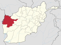 | |
|---|---|---|
| Districts | ||
| Cities |
| |
| Landmarks |
| |
This article is issued from
Wikipedia.
The text is licensed under Creative Commons - Attribution - Sharealike.
Additional terms may apply for the media files.