Zabul Province
| Zabul زابل | |
|---|---|
| Province | |
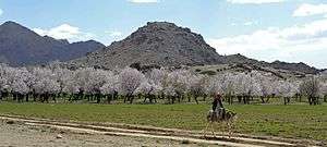
 An aircraft flies past the Spin Ghar mountains on approach for a routine supply drop in Shah Joy district | |
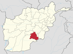 Map of Afghanistan with Zabul highlighted | |
| Coordinates: 32°06′N 67°06′E / 32.1°N 67.1°ECoordinates: 32°06′N 67°06′E / 32.1°N 67.1°E | |
| Country |
|
| Capital | Qalat |
| Government | |
| • Governor | Bismillah Afghanmal |
| Area[1][2] | |
| • Total | 17,343 km2 (6,696 sq mi) |
| Population (2015)[3] | |
| • Total | 304,126 |
| • Density | 18/km2 (45/sq mi) |
| Time zone | UTC+4:30 |
| ISO 3166 code | AF-ZAB |
| Main languages | Pashto |
Zabul (Persian and Pashto: زابل) is one of the 34 provinces of Afghanistan, located in the south of the country. It has a mostly rural population of about 289,300.[4] Zabul became an independent province from neighbouring Kandahar in 1963. Historically, it was part of the Zabulistan region. Qalat serves as the capital of the province.
History
Geography
Zabul borders Oruzgan in the north, Kandahar in the west and in the south, Ghazni and Paktika in the east. It borders Pakistan in the east; the Zhob district of Pakistani Balochistan is sometimes regarded as an extension of Zabul.
The province covers an area of 17293 km2. Two-fifths of the province is mountainous or semi mountainous terrain (41%) while more than one quarter of the area is made up of flat land (28%).
The primary ecoregion of the province is the central Afghan mountains xeric woodlands. Common vegetation is listed as dry shrub-land and pistachio. The high mountains of the northern portion of the province are in the Ghor-Hazarajat alpine meadow ecoregion, which is characterized by meadows, willows, and sea buckthorn.[5]
Politics and governance
The current governor of the province is Bismillah Afghanmal.The city of Qalat is the capital of the province. All law enforcement activities throughout the province are controlled by the Afghan National Police (ANP). Zabul's border with neighboring Balochistan province of Pakistan is monitored the Afghan Border Police (ABP).Plans are underway to construct new border stations in the near future. The provincial police chief represents the Ministry of the Interior in Kabul. The ANP is backed by other Afghan National Security Forces (ANSF), including the National Directorate of Security (NDS) and NATO-led forces.
The province has especially struggled with retaining NGO's and teachers in the face of Taliban attacks and threats. Until 2006, the only major international presence was an American Provincial Reconstruction Team Zabul (PRT) based in Qalat District 32°07′47″N 066°55′41″E / 32.12972°N 66.92806°E, when it was joined by a UNAMA & USAID/DAI branch.
Transportation
In 2006, the province's first airstrip was opened near Qalat, to be operated by the Afghan National Army, but also for use by commercial aviation. Twice weekly service was scheduled by PRT Air between Qalat and Kabul. The airstrip is not paved.[6] The ANA Chief in Zabul is Major General Jamaluddin Sayed[7]
Zabul Province is bisected by Highway 1 and travelers going between Kandahar and Kabul via road typically pass through the province.[8]
On 4 September 2016, at least 38 people were killed and 28 were injured during the September 2016 Afghanistan road crash.
Healthcare
The percentage of households with clean drinking water increased from 0% in 2005 to 32% in 2011.[9] The percentage of births attended to by a skilled birth attendant increased from 1% in 2005 to 5% in 2011.[9]
Education
The overall literacy rate (6+ years of age) increased from 1% in 2005 to 19% in 2011.[9] The overall net enrolment rate (6–13 years of age) fell from 31.3% in 2005 to 5% in 2011.[9]
Demographics
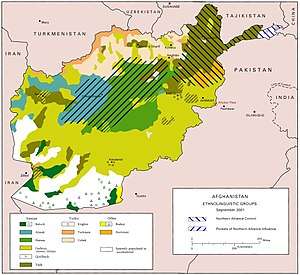
The total population of the province is about 289,300, which is mostly a rural tribal society.[4] According to the Naval Postgraduate School, the population is primarily Pashtun, sprinkled throughout around 2,500 remote villages. Major tribal groups include the Tokhi and Hotaki Ghilji and the Noorzai and Panjpai Durrani.
Pashto is the dominant language in the area. The people of Zabul are overwhelmingly Sunni Muslim. Primary occupations within Zabul are agriculture and animal husbandry.[10]
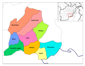
Districts
| District | Capital | Population (2013)[4] | Area | Notes |
|---|---|---|---|---|
| Arghandab | 31,700 | Sub-divided in 2005 | ||
| Atghar | 8,400 | |||
| Daychopan | 38,300 | |||
| Kakar | 23,400 | Created in 2005 within Argahandab District | ||
| Mizan | 13,400 | |||
| Naw Bahar | 18,300 | Created in 2005 from parts of Shamulzayi and Shinkay Districts | ||
| Qalat | Qalat | 34,300 | ||
| Shah Joy | 56,800 | |||
| Shamulzayi | 25,100 | |||
| Shinkay | 22,900 | |||
| Tarnak Aw Jaldak | 16,700 |
Sports
The province is represented in Afghan domestic cricket by the Zabul Province cricket team.
Gallery
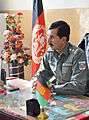 Afghan National Police 1st Lt. Sardar Hotak, the police chief of Shah Joy district, speaks with guests before a graduation ceremony for Afghan Local Police cadets at the district center
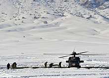 Afghan police and coalition special operations forces load a police member needing medical care onto an MH-60 Black Hawk helicopter during a medical evacuation in the Shah Joy district in (January 2012)
 Afghan children watch U.S. Soldiers and Airmen as they pass through their village near Forward Operating Base Lane (August 2010)
 Sgt. Johnny Hoyos patrolling the area around a bridge on the Kabul–Kandahar Highway during a quality assurance, quality control visit in 2010.
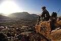 A U.S. soldier watches the sunrise after a dismounted patrol mission near Forward Operating Base Baylough, Zabul province.
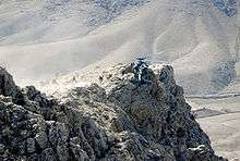 U.S. Special Forces are extracted from a mountain pinnacle in Zabul province
 An early-morning dismounted patrol mission near Forward Operating Base Baylough, Zabul
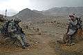 U.S. soldiers drinking tea at an Afghan National Army outpost
See also
References
- ↑ Provinces of Afghanistan on Statoids.
- ↑ "Afghanistan's Provinces – Zabul at USAID". usaid.gov. Retrieved 2 April 2018.
- ↑ "Afghanistan at GeoHive". geohive.com. Retrieved 2 April 2018.
- 1 2 3 "Settled Population of Zabul province by Civil Division, Urban, Rural and Sex-2012-13" (PDF). Islamic Republic of Afghanistan, Central Statistics Organization. Retrieved 2013-06-22.
- ↑ World Wildlife Fund, ed. (2001). "Central Afghan Mountains xeric woodlands". WildWorld Ecoregion Profile. National Geographic Society. Archived from the original on 2010-03-08.
- ↑ First Airstrip in Zabul Province, USAID
- ↑ Online, Asia Time. "Asia Times Online :: South Asia news, business and economy from India and Pakistan". www.atimes.com. Retrieved 2 April 2018.
- ↑ "The Back of Beyond: A Report from Zabul Province". worldaffairsjournal.org. Retrieved 2 April 2018.
- 1 2 3 4 Archive, Civil Military Fusion Centre, https://www.cimicweb.org/AfghanistanProvincialMap/Pages/Zabul.aspx
- ↑ "Zabul Province". Program for Culture & Conflict Studies. Naval Postgraduate School. Retrieved 2013-06-16.
External links
| Wikimedia Commons has media related to Zabul Province. |
Places adjacent to Zabul Province | ||||||||||
|---|---|---|---|---|---|---|---|---|---|---|
| ||||||||||