Tohono O'odham Indian Reservation
Coordinates: 32°09′01″N 112°02′41″W / 32.15028°N 112.04472°W
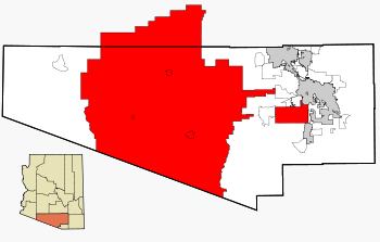
The Tohono O'odham Indian Reservation, is an Indian reservation of the Tohono O'odham Nation located in Arizona, United States.[1] The reservation had a total 2000 census population of 10,787.The reservation is has a land area of 11,243.098 square kilometres (4,340.984 sq mi), 97.48 percent of the Tohono O'odham Nation total area. The reservation encompasses portions of central Pima, southwestern Pinal, and southeastern Maricopa Counties.
The land is also site of the Quinlan and Baboquivari Mountains, which include Kitt Peak, and the Kitt Peak National Observatory and telescopes, as well as Baboquivari Peak. These astronomical sites are under lease from the Tohono O'odham Nation. The lease was approved by the council in the 1950s, for a one-time payment of US$25,000 plus $10 per acre per year.[2]
Tohono O'odham Nation communities
- Chuichu
- Pisinemo
- Santa Rosa (Kaij Mek)
- Sells
- Topawa
- Kaka
- Kohatk
- Tat Momoli
- Why (portion)
- Gu-Vo, Arizona
- Hickiwan, Arizona
Communications
The telephone area code for the Tohono O'odham Reservation is 520.
References
- ↑ "Home". Official Website of the Tohono O'odham Nation. 2014. Retrieved 2014-04-24.
- ↑ "Astronomy Development on Another Sacred Mountain: Kitt Peak". Mauna Kea – From Mountain to Sea. Na Maka o ka Aina. 2005. Archived from the original on 2008-08-20. Reprinting material from the Arizona Daily Star, 2005.
See also: Indigenous peoples of Arizona |


