Ray, Arizona
| Ray, Arizona | |
|---|---|
| Populated place | |
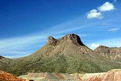 Teapot Mesa, above Ray mine | |
 Ray Location in the state of Arizona | |
| Coordinates: 33°11′00″N 110°59′51″W / 33.18333°N 110.99750°WCoordinates: 33°11′00″N 110°59′51″W / 33.18333°N 110.99750°W | |
| Country | United States |
| State | Arizona |
| County | Pinal |
| Elevation[1] | 2,123 ft (647 m) |
| Time zone | UTC-7 (MST (no DST)) |
Ray is a populated place in Pinal County, Arizona, United States; it is mostly known for the large copper mine there. It was named after the nearby Ray mine, which was begun by the Ray Copper Company in 1882, after the sister of one of the miner's, whose name was Bullinger.[1]
The town of Kearny was founded by the Kennecott Mining Company in 1958 as a planned community to accommodate the populations of Ray, Barcelona and Sonora, which were about to be enveloped by Kennecott's copper mine. Relocation to Kearny began in 1958.
The Copper Basin Railway runs through the town.
Notable residents
- Edward Landers Drew, died during a shootout near Ray, 1911
- Tom Graeff, actor, producer, director, born in Ray
- Gory Guerrero, wrestler, born in Ray
- Jeanmarie Simpson, born in Ray
- Clay O'Bien, child actor, born in Ray
References

Ray, Arizona in 1908. The old townsite was consumed by the Ray mine open pit.
External links
| Wikimedia Commons has media related to Ray Mine. |

This article is issued from
Wikipedia.
The text is licensed under Creative Commons - Attribution - Sharealike.
Additional terms may apply for the media files.