Buckeye, Arizona
| Buckeye, Arizona | |
|---|---|
| City | |
| City of Buckeye | |
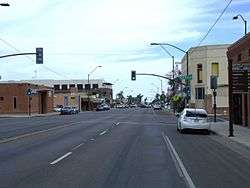 Historic Buckeye downtown as seen from Monroe Avenue in October 2015 | |
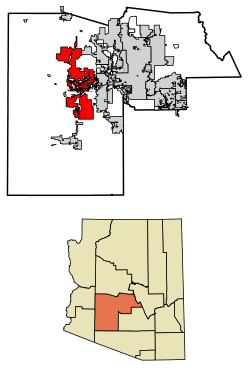 Location of Buckeye in Maricopa County, Arizona | |
 Buckeye Location of Buckeye in Maricopa County, Arizona  Buckeye Buckeye (the US) | |
| Coordinates: 33°22′14″N 112°35′27″W / 33.37056°N 112.59083°WCoordinates: 33°22′14″N 112°35′27″W / 33.37056°N 112.59083°W | |
| Country | United States |
| State | Arizona |
| County | Maricopa |
| Government | |
| • Mayor | Jackie M. Meck[1] |
| • City Council |
Tony Youngker Patrick HagEstad Michelle Hess Jeanine Guy Craig Heustis Eric Orsborn |
| • City Manager | Roger Klingler |
| Area[2] | |
| • Total | 392.65 sq mi (1,016.96 km2) |
| • Land | 392.52 sq mi (1,016.62 km2) |
| • Water | 0.13 sq mi (0.34 km2) |
| Elevation | 869 ft (265 m) |
| Population (2010)[3] | |
| • Total | 50,876 |
| • Estimate (2017)[4] | 68,453 |
| • Density | 174.39/sq mi (67.33/km2) |
| Time zone | UTC−7 (MST (no DST)) |
| ZIP codes | 85326, 85396 |
| Area code(s) | 623, 602, 480, 928 |
| FIPS code | 04-07940 |
| GNIS feature ID | 2081 |
| Website | http://www.buckeyeaz.gov/ |
Buckeye is a city in Maricopa County, Arizona and is the westernmost suburb in the Phoenix metropolitan area. The population was 62,582 in 2015.[5] It is one of the fastest-growing cities in the US; in 2016, it placed seventh.[6]
History
Early settler Malin M. Jackson developed 10 miles (16 km) of the Buckeye Canal from 1884 to 1886, which he named after his home state of Ohio's moniker, "The Buckeye State". The town was founded in 1888 and originally named "Sidney," after Jackson's home town in Ohio. However, because of the significance of the canal, the town became known as Buckeye. The name was legally changed to Buckeye in 1910. The town was incorporated in 1929, at which time it included 440 acres (180 ha). The town's first mayor was Hugh M. Watson (1956–1958), who founded the Buckeye Valley Bank. Today, Watson Road is the site of the city's commercial center.[7]
In 2008, Buckeye was featured on The NewsHour with Jim Lehrer as part of a week-long series entitled "Blueprint America."[8]
In 2013, a video featuring a Verrado High School student who overcame Down's Syndrome to join the school's cheerleading squad, and using the Katy Perry song "Roar", was selected as a finalist in a Good Morning America contest.[9]
A vote to change the town into the City of Buckeye became effective in 2014.[10]
In November 2017, media outlets reported that a company associated with billionaire Bill Gates purchased 24,800 acres (100 km2) between Buckeye and Tonopah for $80 million. Gates's company plans to create a "smart city" called Belmont on the site.[11]
Geography
Buckeye is located approximately 30 miles (48 km) west of downtown Phoenix.
According to the United States Census Bureau, the city has a total area of 145.8 square miles (377.6 km2), all of it land.
Neighborhoods
The original Buckeye was built around downtown's main street, Monroe Avenue. There are currently nearly 30 master planned communities planned for Buckeye. Such master planned communities under development in which homes are occupied include Riata West, Sundance, Verrado, Westpark, Tartesso and Festival Ranch.
Other unbuilt planned communities within Buckeye include Douglas Ranch (planned for nearly 300,000 inhabitants), Sun Valley Villages, Spurlock Ranch, Trillium, Elianto, Westwind, Silver Rock, Sienna Hills, Henry Park, Southwest Ranch and Montierre.
Sundance Towne Center, a shopping center developed by Vestar Development in the Sundance community, opened in 2007.
Climate
Buckeye has a hot desert climate (Köppen BWh), with abundant sunshine due to the stable descending air of the eastern side of the subtropical anticyclone aloft and at sea level over the southwestern United States. Summers, as with most of the Sonoran Desert, are extremely hot, with 121.0 afternoons reaching 100 °F or 37.8 °C and 181.6 afternoons getting to 90 °F or 32.2 °C. The record high temperature of 125 °F (51.7 °C) occurred on July 28, 1995, and temperatures above 86 °F or 30 °C may occur in any month. Less hot weather may occasionally occur during summer, but such periods are no less unpleasant as they result from monsoonal weather with its attendant higher cloudiness and humidity; however actual rainfall from the monsoon is much more infrequent than in Flagstaff, Nogales or even Tucson. The heaviest daily rainfall has been 4.90 inches (124.5 mm) on September 2, 1894, but between 1971 and 2000 no month had more rainfall than 4.52 inches or 114.8 millimetres in December 1984.
The winter season from November to March is warm to very warm during the day, not much cooler than 68 °F or 20 °C during a typical afternoon, but 20.2 mornings typically fall to or below 32 °F or 0 °C, though no snowfall was recorded during the 1971 to 2000 period, and only twelve afternoons did not reach 50 °F or 10 °C. The coldest temperature recorded in Buckeye was 11 °F or −11.7 °C on January 8, 1913.
| Climate data for Buckeye, Arizona (1971–2000); extremes 1893–2001 | |||||||||||||
|---|---|---|---|---|---|---|---|---|---|---|---|---|---|
| Month | Jan | Feb | Mar | Apr | May | Jun | Jul | Aug | Sep | Oct | Nov | Dec | Year |
| Record high °F (°C) | 100 (38) |
92 (33) |
101 (38) |
106 (41) |
115 (46) |
122 (50) |
125 (52) |
120 (49) |
119 (48) |
108 (42) |
96 (36) |
87 (31) |
125 (52) |
| Average high °F (°C) | 68.3 (20.2) |
73.2 (22.9) |
78.7 (25.9) |
87.3 (30.7) |
95.9 (35.5) |
105.8 (41) |
108.4 (42.4) |
106.3 (41.3) |
101.0 (38.3) |
90.0 (32.2) |
76.8 (24.9) |
68.2 (20.1) |
88.3 (31.3) |
| Average low °F (°C) | 36.7 (2.6) |
40.4 (4.7) |
44.6 (7) |
49.6 (9.8) |
57.5 (14.2) |
65.3 (18.5) |
74.2 (23.4) |
73.6 (23.1) |
66.1 (18.9) |
53.1 (11.7) |
41.3 (5.2) |
35.8 (2.1) |
53.2 (11.8) |
| Record low °F (°C) | 11 (−12) |
18 (−8) |
20 (−7) |
29 (−2) |
32 (0) |
42 (6) |
49 (9) |
48 (9) |
41 (5) |
26 (−3) |
20 (−7) |
12 (−11) |
11 (−12) |
| Average rainfall inches (mm) | 0.80 (20.3) |
0.80 (20.3) |
0.99 (25.1) |
0.26 (6.6) |
0.15 (3.8) |
0.07 (1.8) |
0.67 (17) |
1.22 (31) |
0.75 (19) |
0.64 (16.3) |
0.64 (16.3) |
0.92 (23.4) |
7.91 (200.9) |
| Average rainy days (≥ 0.01 inch) | 3.4 | 3.1 | 4.0 | 1.5 | 0.8 | 0.4 | 2.0 | 4.1 | 2.4 | 2.3 | 1.9 | 3.1 | 29 |
| Source: National Oceanic and Atmospheric Administration[12] | |||||||||||||
Demographics
| Historical population | |||
|---|---|---|---|
| Census | Pop. | %± | |
| 1900 | 200 | — | |
| 1910 | 684 | 242.0% | |
| 1920 | 726 | 6.1% | |
| 1930 | 1,077 | 48.3% | |
| 1940 | 1,305 | 21.2% | |
| 1950 | 1,932 | 48.0% | |
| 1960 | 2,286 | 18.3% | |
| 1970 | 2,599 | 13.7% | |
| 1980 | 3,434 | 32.1% | |
| 1990 | 4,436 | 29.2% | |
| 2000 | 6,537 | 47.4% | |
| 2010 | 50,876 | 678.3% | |
| Est. 2017 | 68,453 | [4] | 34.5% |
| U.S. Decennial Census[13] | |||
In 2015, the population of the city was 62,582 people living in 21,628 households.[5]
As of the census of 2010, there were 50,876 people residing in 16,499 households in the city. The population density was 135.6 people per square mile (17.3/km²). There were 18,207 housing units. 10.8% of the population were born overseas.
In terms of age brackets, the population was spread out with 9.1% under the age of 5; 30.6% under the age of 18; 53% aged between 18 and 64 and 6.7% were 65 years of age or older. 45.4% percent of the population are women.
From 2012 to 2016, the median income for a household in the town was $58,711. The per capita income for the town was $20,446. Both of these numbers are in 2016 dollars. About 12.4% of the population were below the poverty line.
Parks and recreation
A popular recreation destination in Buckeye is the Buckeye Hills Recreation Area. It is located 7 miles (11 km) south of downtown Buckeye on State Route 85 (at mile marker 144). A 900-acre (3.6 km2) Buckeye Lake is planned. The City of Buckeye's Skyline Regional Park is an 8,700 acre mountain preserve located in the southern White Tank Mountains. The park features 8 miles of trails for hikers, mountain bikers and equestrians, picnic areas and camping. Entry to the park is free. By the end of September 2016, 9 additional miles of trails will be constructed for a total of 17 miles of trails.
Education
The City of Buckeye is served by the following school districts:
- Buckeye Elementary School District
- Agua Fria Union High School District
- Liberty Elementary School District
- Buckeye Union High School District
- Wickenburg Unified School District
- The Odyssey Preparatory Academy
- Litchfield Elementary School District
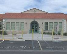
Estrella Mountain Community College recently renovated the original historic Buckeye Union High School building on Eason Avenue near 9th Street, also known as the "A" Wing, and started holding classes in this new satellite facility in the Fall of 2011. Named the Buckeye Educational Center, this facility provides academic courses, job training programs and community education classes.[15]
Media
There are several local newspapers including the West Valley View, Arizona Republic's Southwest Valley edition and the Buckeye Valley News.[16]
Infrastructure
Transportation
Buckeye is served by five highways, a municipal airport and several nearby airports, and the railroad.[17]
Roads
Major roadways serving the city include:


- Sun Valley Parkway
- Maricopa County (MC) 85
Bus
Buckeye is served by Valley Metro via a rural bus line connecting Phoenix-Goodyear-Gila Bend-Ajo.[18]
Rail
In 1910, the Arizona Eastern Railroad came to Buckeye; the first car in 1911; a steam rail line connected it to Phoenix by 1912; and a state highway by 1915. The coming of the railroad was so significant that the business district was moved to accommodate the location of the railroad station. As a result, Buckeye was booming. By 1912, major buildings were constructed, along with expansion of the business community.[7]
Union Pacific operates a rail line running east-west generally through the center of the city.[19]
Air
The Buckeye Municipal Airport (ICAO identifier KBXK), is owned and operated by the city government.[20][21]
Notable people
- Kole Calhoun, Los Angeles Angels of Anaheim outfielder (2012–present)
- Upton Sinclair (1878–1968), author
References
- ↑ "Mayor Jackie A. Meck - Buckeye, Arizona - City of Buckeye, Arizona". www.mayormeck.com.
- ↑ "2017 U.S. Gazetteer Files". United States Census Bureau. Retrieved Aug 7, 2018.
- ↑ "American FactFinder". United States Census Bureau. Retrieved June 18, 2014.
- 1 2 "Population and Housing Unit Estimates". Retrieved March 24, 2018.
- 1 2 "Buckeye's 2015 special census count reveals city's official population". Retrieved 2018-01-06.
- ↑ "Buckeye ranked seventh-fastest growing city". West Valley News. Retrieved 6 January 2018.
- 1 2 "Archived copy". Archived from the original on July 14, 2014. Retrieved July 8, 2014.
- ↑ "America in Gridlock ~ [VIDEO] Nowhere to Grow - Blueprint America - PBS". Public Broadcasting Service. October 15, 2008.
- ↑ "Katy Perry 'Roar' Contest: Girl With Down Syndrome Stars in Finalist Video". ABC News. October 7, 2013.
- ↑ "Buckeye officially changes name from 'town' to 'city'", cbs5az.com
- ↑ "Bill Gates invests $80 million to build Arizona smart city," http://money.cnn.com/2017/11/13/technology/future/bill-gates-smart-city-arizona/index.html, accessed 16 Jan 2018
- ↑ "Climatography of the United States No. 20: 1971–2000 – Buckeye, AZ" (PDF). National Oceanic and Atmospheric Administration. 2004. Retrieved on November 21, 2016.
- ↑ "Census of Population and Housing". Census.gov. Retrieved June 4, 2016.
- ↑ "Buckeye Union High School School A-Wing". U.S. Department of the Interior. Retrieved March 28, 2017.
- ↑ "Career and Education / Home". www.mcrsd.org. Retrieved 2018-03-01.
- ↑ "Buckeye Valley News".
- ↑ "Archived copy". Archived from the original on December 12, 2010. Retrieved July 9, 2014.
- ↑ "Route 785 makes new stops in Buckeye" (Press release). Valley Metro. January 16, 2014. Archived from the original on July 14, 2014.
- ↑ "Arizona Railroads" (PDF). Arizona Department of Transportation.
- ↑ "Buckeye Municipal Airport". City of Buckeye.
- ↑ "Archived copy". Archived from the original on July 2, 2014. Retrieved July 8, 2014.
External links
| Wikimedia Commons has media related to Buckeye, Arizona. |
