Arlington, Arizona
| Arlington, Arizona | |
|---|---|
| Census-designated place | |
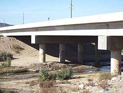 The Hassayampa Bridge listed in the National Register of Historic Places, reference #88001658 | |
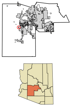 Location of Arlington in Maricopa County, Arizona. | |
 Arlington, Arizona Location within the state of Arizona | |
| Coordinates: 33°19′32″N 112°45′51″W / 33.32556°N 112.76417°WCoordinates: 33°19′32″N 112°45′51″W / 33.32556°N 112.76417°W | |
| Country | United States |
| State | Arizona |
| County | Maricopa |
| Area[1] | |
| • Total | 2.29 sq mi (5.94 km2) |
| • Land | 2.29 sq mi (5.94 km2) |
| • Water | 0.00 sq mi (0.00 km2) |
| Population (2010) | |
| • Total | 194 |
| • Estimate (2016)[2] | N/A |
| Time zone | UTC-7 (Mountain (MST)) |
| ZIP codes | 85322 |
| FIPS code | 04-04020 |
Arlington is a census-designated place in Maricopa County, Arizona, United States, located about 40 miles west of Phoenix on old U.S 80. It follows the street numbering system of Phoenix. As of the 2010 census, the population was 194.
Demographics
| Historical population | |||
|---|---|---|---|
| Census | Pop. | %± | |
| U.S. Decennial Census[3] | |||
As of the census[4] of 2010, there were 194 people residing in the CDP. The population density was 82.8 people per square mile. The racial makeup of the CDP was 69.07% White, 0.52% Black or African American, 1.55% Native American, 24.23% from other races, and 4.64% from two or more races. 29.90% of the population were Hispanic or Latino of any race.
Hassayampa Bridge
The historic Hassayampa River Bridge, listed on the National Register of Historic Places, is located nearby.
References
- ↑ "2016 U.S. Gazetteer Files". United States Census Bureau. Retrieved July 18, 2017.
- ↑ "Population and Housing Unit Estimates". Retrieved June 9, 2017.
- ↑ "Census of Population and Housing". Census.gov. Retrieved June 4, 2016.
- ↑ "Archived copy". Archived from the original on July 26, 2011. Retrieved October 18, 2013.

This article is issued from
Wikipedia.
The text is licensed under Creative Commons - Attribution - Sharealike.
Additional terms may apply for the media files.