Wahak Hotrontk, Arizona
| Wahak Hotrontk, Arizona | |
|---|---|
| Census-designated place | |
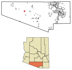 Location of Wahak Hotrontk in Pima County, Arizona. | |
 Wahak Hotrontk Location of Wahak Hotrontk in Pima County, Arizona. | |
| Coordinates: 32°10′58″N 112°21′56″W / 32.18278°N 112.36556°WCoordinates: 32°10′58″N 112°21′56″W / 32.18278°N 112.36556°W | |
| Country | United States |
| State | Arizona |
| County | Pima |
| Area[1] | |
| • Total | 1.54 sq mi (3.99 km2) |
| • Land | 1.54 sq mi (3.99 km2) |
| • Water | 0.00 sq mi (0.00 km2) |
| Elevation | 1,939 ft (591 m) |
| Population (2000)[2] | |
| • Total | 2,380 |
| • Estimate (2016)[3] | N/A |
| Time zone | UTC-7 (Mountain (MST)) |
| Area code(s) | 520 |
| GNIS feature ID | 13276[4] |
Wahak Hotrontk is a census-designated place in Pima County, in the U.S. state of Arizona.[4] The population was 114 at the 2010 census.[2]
Geography
According to the U.S. Census Bureau, the community has an area of 1.541 square miles (3.99 km2), all of it land.[2]
Demographics
| Historical population | |||
|---|---|---|---|
| Census | Pop. | %± | |
| U.S. Decennial Census[5] | |||
References
- ↑ "2016 U.S. Gazetteer Files". United States Census Bureau. Retrieved Jul 18, 2017.
- 1 2 3 "2010 Census Gazetteer Files - Places: Arizona". U.S. Census Bureau. Retrieved February 26, 2017.
- ↑ "Population and Housing Unit Estimates". Retrieved June 9, 2017.
- 1 2 "Wahak Hotrontk". Geographic Names Information System. United States Geological Survey.
- ↑ "Census of Population and Housing". Census.gov. Retrieved June 4, 2016.

This article is issued from
Wikipedia.
The text is licensed under Creative Commons - Attribution - Sharealike.
Additional terms may apply for the media files.