Wittmann, Arizona
| Wittmann, Arizona | |
|---|---|
| Census-designated place | |
 Nadaburg School House | |
 Location of Wittmann in Maricopa County, Arizona. | |
 Wittmann, Arizona Location in the United States | |
| Coordinates: 33°46′35″N 112°31′43″W / 33.77639°N 112.52861°WCoordinates: 33°46′35″N 112°31′43″W / 33.77639°N 112.52861°W | |
| Country | United States |
| State | Arizona |
| County | Maricopa |
| Area[1] | |
| • Total | 0.96 sq mi (2.50 km2) |
| • Land | 0.96 sq mi (2.50 km2) |
| • Water | 0.00 sq mi (0.00 km2) |
| Population (2010) | |
| • Total | 9,655 |
| • Estimate (2016)[2] | N/A |
| Time zone | UTC-7 (Mountain (MST)) |
| ZIP codes | 85361 |
| Area code(s) | 623 |
| FIPS code | 04-84140 |
Wittmann is a census-designated place in Maricopa County, Arizona, United States. It is located along U.S. Route 60 in the central part of Arizona, about 35 miles northwest of central Phoenix, and while technically located within the city's metropolitan area it is generally regarded by locals to be just outside it. As of the 2010 census, there were 6700 people living in the Wittmann area (Zip Code 85361).
A variant name was Nadaburg; the present name is for one Mr. Wittmann, an official who falsely promised to build a dam nearby which would benefit the town.[3]
History
The town was first named Nadaburg, which is a combination of two words, the Spanish word "Nada", which means "nothing" and the German word "burg", which means "town". The railroad who built the Southern Transcontinental Railroad line named the site Nadaburg years before the area was formally opened to homesteading as a result of the Department of Interior Act of December 29, 1916.[4][5]
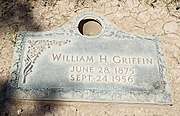
William Hovey Griffin, a native of Texas, founded the town of Nadaburg (Wittmann). He filed his homestead petition in September 1920. That same year he also plotted out the town site. Griffin donated a block of land to the Maricopa County School District where the little Red School House (it was white at that time) was built. The school currently serves as the Nadaburg Unified School District Governing Board’s Boardroom.[4][5]
Joseph Wittmann promised to build a dam on the Hassayampa River, which would bring irrigation water to the town of Nadaburg. In 1926, lots and acreage were given to Wittmann, by the citizens of Nadaburg, as payment for the construction of the dam. In 1930, the people of Nadaburg changed the name of the town to Wittmann, honoring the man who promised them the water that would irrigate their fields. However, Wittmann never kept his promise and the citizens of the town sued him. At least half of the citizens were able to recover their lands.[4][5]
Demographics
| Historical population | |||
|---|---|---|---|
| Census | Pop. | %± | |
| U.S. Decennial Census[6] | |||
As of the census[7] of 2010, there were 6700 people residing in the Wittmann area (Zip Code 85361). The population density was 56.3 people per square mile. The racial makeup of Wittmann was 83.8% White, 0.8% Black or African American, 1.2% Native American, 0.5% Asian, 0.1% Pacific Islander, 10.6% from other races, and 3.0% from two or more races. 24.0% of the population were Hispanic or Latino of any race.
Images


References
- ↑ "2016 U.S. Gazetteer Files". United States Census Bureau. Retrieved July 18, 2017.
- ↑ "Population and Housing Unit Estimates". Retrieved June 9, 2017.
- ↑ U.S. Geological Survey Geographic Names Information System: Wittmann, Arizona
- 1 2 3 History of Nadaburg
- 1 2 3 "A brief history of a tiny western town" by: Rock Betu
- ↑ "Census of Population and Housing". Census.gov. Retrieved June 4, 2016.
- ↑
