Sentinel, Arizona
| Sentinel, Arizona | |
|---|---|
| Populated place | |
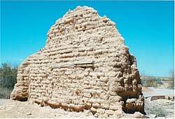 Ruins of the 1895 Sentinel Train Depot | |
 Sentinel Location within the state of Arizona  Sentinel Sentinel (the US) | |
| Coordinates: 32°51′29″N 113°12′38″W / 32.85806°N 113.21056°WCoordinates: 32°51′29″N 113°12′38″W / 32.85806°N 113.21056°W | |
| Country | United States |
| State | Arizona |
| County | Maricopa |
| Elevation[1] | 692 ft (211 m) |
| Time zone | UTC-7 (Mountain (MST)) |
| • Summer (DST) | UTC-7 (MST) |
| Area code(s) | 928 |
| FIPS code | 04-65630 |
| GNIS feature ID | 11083 |
Sentinel is a populated place situated in Maricopa County, Arizona.[2] It has an estimated elevation of 692 feet (211 m) above sea level.[1]
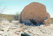
Sentinel ruins
Some of the few remaining late 19th Century ruins in Sentinel
Ruins in Sentinel, Arizona

1890 Ranch house.
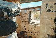
Inside the Ranch house.

Basement of the Ranch house
Ruins of the 1895 Sentinel Train Depot
References
- 1 2 "Feature Detail Report for: Sentinel". Geographic Names Information System. United States Geological Survey.
- ↑ "Sentinel (in Maricopa County, AZ) Populated Place Profile". AZ Hometown Locator. Retrieved March 18, 2017.

This article is issued from
Wikipedia.
The text is licensed under Creative Commons - Attribution - Sharealike.
Additional terms may apply for the media files.