Maricopa, Arizona
| Maricopa, Arizona | |
|---|---|
| City | |
 Residential developments dominate the landscape of Maricopa | |
 Location of Maricopa in Pinal County, Arizona | |
 Maricopa, Arizona Location in the United States | |
| Coordinates: 33°3′24″N 112°2′48″W / 33.05667°N 112.04667°WCoordinates: 33°3′24″N 112°2′48″W / 33.05667°N 112.04667°W | |
| Country | United States |
| State | Arizona |
| County | Pinal |
| Incorporated | 2003 |
| Government | |
| • Mayor | Christian Price |
| • Vice Mayor | Marvin L. Brown |
| • City Council | Peg Chapados, Julia Gusse, Vincent Manfredi, Nancy Smith, Henry Wade |
| • City Manager | Gregory Rose |
| • City Clerk | Vanessa Bueras |
| Area[1] | |
| • Total | 41.11 sq mi (106.47 km2) |
| • Land | 41.01 sq mi (106.23 km2) |
| • Water | 0.10 sq mi (0.25 km2) |
| Elevation | 1,190 ft (358 m) |
| Population (2010)[2] | |
| • Total | 43,482 |
| • Estimate (2016)[3] | 46,903 |
| • Density | 1,143.59/sq mi (441.54/km2) |
| Time zone | UTC-7 (MST (no DST)) |
| ZIP code | 85138, 85139 |
| Area code(s) | 520 |
| FIPS code | 04-44410 |
| Website | http://www.maricopa-az.gov/web/ |
Maricopa is a city in the Gila River Valley in Arizona. With an estimated 50,174 residents as of 2018, Maricopa is the second most populous incorporated city in Pinal County and eighteenth most populous in Arizona.[4] Maricopa forms part of the Phoenix metropolitan area.
History
Maricopa has had three locations over the years: Maricopa Wells, Maricopaville and Maricopa Junction; the latter gradually became known as Maricopa. It started as an oasis around a series of watering holes eight miles north of present-day Maricopa, and about a mile west of Pima Butte. European-American traders and travelers called it Maricopa Wells. Several of Arizona’s rivers, the Gila, Santa Cruz, Vekol and Santa Rosa provided this oasis in the desert with an ample supply of water during this period of time.
During the late 1800s, Maricopa Wells was one of the most important relay stations along the San Antonio-San Diego Mail Line and the later more famous Butterfield Overland Mail Route. Although little remains of this once bustling community, it played an important part in the progress and development of the Southwest. It was one of the best-known spots in Arizona during this period of time because it had a reliable source of water, and offered an abundant supply of food. The peaceful Pima and Maricopa farmers who lived and farmed nearby sold supplies to travelers and migrants.
The most prosperous period of time for Maricopa Wells was in the 1870s. During this time the trading center at the Wells provided water and food for not only the east-west travelers, but those who traveled to the north to Phoenix. Fairly good roads had been built by James A. Moore, the proprietor at Maricopa Wells, to all points north, and the Wells was a constant hubbub of activity.
Maricopaville developed south and west of the Wells, following construction of a railroad line from this terminus to Phoenix. In 1879, the Southern Pacific Railroad was in the process of building a railroad line from Yuma to Tucson, and a second railroad line was to be built from Maricopaville, wrapping around the western edge of South Mountain into Phoenix. With the railroad, Maricopaville took on the appearance of a gold rush California boom town, as men worked day and night building hotels, saloons, warehouses, restaurants, theaters, etc. One newspaper of the time reckoned that with its thousands of people and good location, Maricopaville would be an ideal choice for the location of the state capital.
But the railroad never built the anticipated line from Maricopaville into Phoenix. Tempe also wanted to be on the railroad line and lobbied the territorial government to gain a stop. Officials agreed. The settlement known as Maricopaville was essentially rebuilt three miles to the east (to the present location of Maricopa) in the early 1880s, in order to accommodate the Maricopa & Phoenix line, planned to go through Kyrene and Tempe to the north on the way to Phoenix. The first train departed from Maricopa for Phoenix on July 4, 1887. All east-west rail travelers had to stop at Maricopa, and those who wanted to go north had to shift to the M & P Railroad.[5][6][7]
Maricopa was officially incorporated as a city on October 15, 2003, becoming the 88th incorporated city in Arizona. Between 2000 and 2010, the city's population grew from 1,040 residents to 43,482, an increase of 4080%.[8]
A part of the city is within the boundaries of the Ak-Chin Indian Community. The small, federally recognized tribe has developed Harrah's Ak-Chin Casino and related resort, a multi-entertainment cinema complex, and operates a golf course; all are open to the public and draw attendees from Maricopa as well as the greater Phoenix area. In addition the tribe operates the Ak-Chin Regional Airport and an industrial park. A 2011 study said that its casino and resort made up a large part of the economy of Pinal County, in terms of number of jobs and revenue generated.
Geography and climate
Maricopa is located at 33°3′24″N 112°2′48″W / 33.05667°N 112.04667°W (33.056702, -112.046656).[9]
According to the United States Census Bureau, the city has a total area of 31.9 square miles (83 km2), all of it land.[10]
The topography in Maricopa is flat with several mountain ranges 10 to 20 miles away. The elevation of Maricopa is 1190 feet.
| Climate data for Maricopa, AZ | |||||||||||||
|---|---|---|---|---|---|---|---|---|---|---|---|---|---|
| Month | Jan | Feb | Mar | Apr | May | Jun | Jul | Aug | Sep | Oct | Nov | Dec | Year |
| Record high °F (°C) | 86 (30) |
90 (32) |
100 (38) |
106 (41) |
113 (45) |
122 (50) |
124 (51) |
117 (47) |
113 (45) |
109 (43) |
95 (35) |
84 (29) |
124 (51) |
| Average high °F (°C) | 68 (20) |
73 (23) |
79 (26) |
88 (31) |
98 (37) |
107 (42) |
108 (42) |
106 (41) |
102 (39) |
90 (32) |
77 (25) |
67 (19) |
89 (31) |
| Average low °F (°C) | 36 (2) |
39 (4) |
44 (7) |
50 (10) |
59 (15) |
68 (20) |
77 (25) |
76 (24) |
68 (20) |
54 (12) |
42 (6) |
35 (2) |
54 (12) |
| Average precipitation inches (mm) | 0.83 (21.1) |
0.91 (23.1) |
1.00 (25.4) |
0.28 (7.1) |
0.17 (4.3) |
0.08 (2) |
0.98 (24.9) |
0.96 (24.4) |
0.72 (18.3) |
0.47 (11.9) |
0.58 (14.7) |
0.97 (24.6) |
7.98 (202.7) |
| Source: The Weather Channel[11] | |||||||||||||
Surrounding municipalities
Places adjacent to Maricopa, Arizona | ||||||||||
|---|---|---|---|---|---|---|---|---|---|---|
| ||||||||||
Demographics
| Historical population | |||
|---|---|---|---|
| Census | Pop. | %± | |
| 2000 | 1,040 | — | |
| 2010 | 43,482 | 4,081.0% | |
| Est. 2016 | 46,903 | [3] | 7.9% |
| U.S. Decennial Census[12] | |||
As of the census of 2010, there were 43,482 people, 14,359 households, and 11,110 families residing in the city. The population density was 1,356.8 people per square mile (526.4/km2). There were 17,240 housing units at an average density of 540.4 per square mile (208.7/km2). The racial makeup of the city was 70.2% White, 9.7% Black or African American, 2.0% Native American, 4.1% Asian, 0.3% Pacific Islander, 8.5% from other races, and 5.3% from two or more races. 24.4% of the population is Hispanic or Latino of any race.
There were 14,359 households out of which 47.1% had children under the age of 18 living with them, 37.5% were married couples living together, 10.9% had a female householder with no husband present, and 22.6% were non-families. 15.6% of all households were made up of individuals and 2.5% had someone living alone who was 65 years of age or older. The average household size was 3.03 and the average family size was 3.38.[13]
In the city, the population was spread out with 32.5% under the age of 18, 6.2% from 18 to 24, 35% from 25 to 44, 19.8% from 45 to 64, and 6.5% who were 65 years of age or older. The median age was 31.2 years. For every 100 females, there were 98.5 males. For every 100 females age 18 and over, there were 94.8 males.
According to 2009 Census Bureau estimates, the median income for a household in the city was $67,692, and the median income for a family was $69,818. The per capita income for the city was $27,618. About 3.7% of families and 5.2% of the population were below the poverty line.
Transportation
Highways to Maricopa include Arizona State Route 238 and Arizona State Route 347. Maricopa lies approximately 15 miles west of Interstate 10 and 15 miles north of Interstate 8.
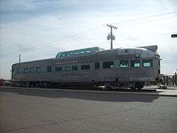
Maricopa is currently the closest stop from Phoenix on Amtrak's Sunset Limited and Texas Eagle trains. The Maricopa depot opened in 2001, originally in a converted passenger rail car but now in a metal building.
Municipal organization
Maricopa is governed by a Council-Manager form of government. This type of government structure combines the political leadership of elected officials with the managerial experience of an appointed professional manager. The City Council and City Manager work as partners to direct and guide local government.
The Maricopa City Council consists of the Mayor and six City Council members. The Mayor is elected to serve a four-year term and the City Council members are elected to serve four-year terms on a rotating basis. City Council meetings are held on the first and third Tuesdays of the month.
There are 10 citizen advisory groups that guide the Maricopa City Council on a myriad of activity. They are the Board of Adjustment, Heritage District Advisory Committee, Industrial Development Authority Board, Merit Board, Parks, Recreation and Library Advisory Committee, Planning and Zoning Commission, Public Safety Personnel Retirement System Board, Transportation Advisory Committee and the Youth Council. Selection to these groups is by City Council action.
The City is organized into nine departments: the City Manager's Office, the City Clerk's Office, Community Services, Development Services, Economic Development, Finance, Fire, Human Services and the Police Department. More than 250 individuals work for the municipality.
Civic and nonprofit organizations
- F.O.R. Maricopa - local food bank
- Maricopa Gun Club- local gun club
- Maricopa Historical Society - area historical organization
- Maricopa Motorcycle Riders - local group of riders; all bikes allowed
- Maricopa Seniors - area senior citizen group
- Pet Social Worker / Tails of Hope Rescue - local animal rescue group
- Recycling Association of Maricopa (R.A.M.) - community drop-off recycling
- Thunderbird Arena Community Council (TACC) - area organization supporting the renovation of the Thunderbird Farms Arena
Education facilities
Public school districts
Public elementary schools
- Butterfield Elementary School
- Mobile Elementary School
- Maricopa Elementary School
- Pima Butte Elementary School
- Saddleback Elementary School
- Santa Cruz Elementary School
- Santa Rosa Elementary School
Public middle schools
- Desert Wind Middle School
- Maricopa Wells Middle School
Public high school
Charter schools
- Camino Montessori School
- Graysmark Academy
- Holsteiner Agricultural School
- Leading Edge Academy
- Legacy Traditional School-Maricopa Campus
- Sequoia Pathway Academy
Community college
Notable people
- Bristol Palin, daughter of former Vice Presidential candidate Sarah Palin, bought a house and lived here for two years before returning to Alaska.[14][15]
- State Senator Steve Smith resides in Maricopa.
Notes
- ↑ "2016 U.S. Gazetteer Files". United States Census Bureau. Retrieved July 18, 2017.
- ↑ "American Fact Finder Maricopa city, Arizona". Retrieved May 20, 2017.
- 1 2 "Population and Housing Unit Estimates". Retrieved June 9, 2017.
- ↑ "Annual Estimates of the Resident Population for Incorporated Places: April 1, 2010 to July 1, 2015". Retrieved May 20, 2017.
- ↑ Reflections of a Desert Town, Patricia Brock
- ↑ "Archived copy". Archived from the original on September 16, 2009. Retrieved July 24, 2010.
- ↑ "Archived copy". Archived from the original on July 23, 2010. Retrieved July 24, 2010.
- ↑ "U.S. Census Data". United States Census Bureau. March 10, 2011. Archived from the original on March 22, 2011. Retrieved March 10, 2011.
- ↑ "US Gazetteer files: 2010, 2000, and 1990". United States Census Bureau. February 12, 2011. Retrieved April 23, 2011.
- ↑ Bureau, U.S. Census. "American FactFinder - Results". factfinder2.census.gov.
- ↑ "Monthly Averages for Maricopa, AZ". Weather.com. 2010. Retrieved September 17, 2012.
- ↑ "Census of Population and Housing". Census.gov. Retrieved June 4, 2016.
- ↑ "Archived copy". Archived from the original on March 5, 2014. Retrieved January 23, 2012.
- ↑ "New Ariz. homeowner: Bristol Palin". Today. MSNBC. December 24, 2010. Archived from the original on December 27, 2010. Retrieved January 2, 2011.
- ↑ "Bristol Palin No Longer an Arizona Homeowner". Zillow. May 2012.
External links
| Wikimedia Commons has media related to Maricopa, Arizona. |
