Tinchebray-Bocage
| Tinchebray-Bocage | |
|---|---|
| Commune | |
 | |
 Tinchebray-Bocage Location within Normandy region  Tinchebray-Bocage | |
| Coordinates: 48°45′49″N 0°43′59″W / 48.7636°N 0.7331°WCoordinates: 48°45′49″N 0°43′59″W / 48.7636°N 0.7331°W | |
| Country | France |
| Region | Normandy |
| Department | Orne |
| Arrondissement | Argentan |
| Canton | Domfront |
| Intercommunality | Canton de Tinchebray |
| Government | |
| • Mayor (2014–2020) | Jérôme Nury |
| Area1 | 99.88 km2 (38.56 sq mi) |
| Population (2013)2 | 5,052 |
| • Density | 51/km2 (130/sq mi) |
| Time zone | UTC+1 (CET) |
| • Summer (DST) | UTC+2 (CEST) |
| INSEE/Postal code | 61486 /61800 |
| Elevation | 77–151 m (253–495 ft) |
| Website | www.tinchebray.fr |
|
1 French Land Register data, which excludes lakes, ponds, glaciers > 1 km2 (0.386 sq mi or 247 acres) and river estuaries. 2 Population without double counting: residents of multiple communes (e.g., students and military personnel) only counted once. | |
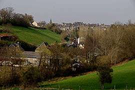
Tinchebray-Bocage is a commune in the Orne department in the Normandy region in north-western France. The result of the merger, on 1 January 2015, of the communes of Beauchêne, Frênes, Larchamp, Saint-Cornier-des-Landes, Saint-Jean-des-Bois, Tinchebray and Yvrandes.[1]
See also
References
| Wikimedia Commons has media related to Tinchebray-Bocage. |
This article is issued from
Wikipedia.
The text is licensed under Creative Commons - Attribution - Sharealike.
Additional terms may apply for the media files.