Chanu
| Chanu | |
|---|---|
| Commune | |
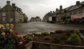 The centre of Chanu | |
 Chanu Location within Normandy region  Chanu | |
| Coordinates: 48°43′46″N 0°40′35″W / 48.7294°N 0.6764°WCoordinates: 48°43′46″N 0°40′35″W / 48.7294°N 0.6764°W | |
| Country | France |
| Region | Normandy |
| Department | Orne |
| Arrondissement | Argentan |
| Canton | Domfront |
| Intercommunality | Communauté de communes de la Visance et du Noireau |
| Government | |
| • Mayor (2008–2014) | Thierry Aubin |
| Area1 | 15.72 km2 (6.07 sq mi) |
| Population (2006)2 | 1,268 |
| • Density | 81/km2 (210/sq mi) |
| Demonym(s) | Chanusiens |
| Time zone | UTC+1 (CET) |
| • Summer (DST) | UTC+2 (CEST) |
| INSEE/Postal code | 61093 /61800 |
| Elevation |
226–321 m (741–1,053 ft) (avg. 299 m or 981 ft) |
| Website | www.chanu.eu |
|
1 French Land Register data, which excludes lakes, ponds, glaciers > 1 km2 (0.386 sq mi or 247 acres) and river estuaries. 2 Population without double counting: residents of multiple communes (e.g., students and military personnel) only counted once. | |
Chanu is a commune in the Orne department in north-western France.
See also
References
| Wikimedia Commons has media related to Chanu. |
This article is issued from
Wikipedia.
The text is licensed under Creative Commons - Attribution - Sharealike.
Additional terms may apply for the media files.