Bonsmoulins
| Bonsmoulins | ||
|---|---|---|
| Commune | ||
 Ruins of the château | ||
| ||
 Bonsmoulins Location within Normandy region  Bonsmoulins | ||
| Coordinates: 48°39′04″N 0°32′12″E / 48.6511°N 0.5367°ECoordinates: 48°39′04″N 0°32′12″E / 48.6511°N 0.5367°E | ||
| Country | France | |
| Region | Normandy | |
| Department | Orne | |
| Arrondissement | Mortagne-au-Perche | |
| Canton | Tourouvre | |
| Intercommunality | Pays de la Marche | |
| Government | ||
| • Mayor (2008–2014) | Monique Langevin | |
| Area1 | 7.57 km2 (2.92 sq mi) | |
| Population (2006)2 | 218 | |
| • Density | 29/km2 (75/sq mi) | |
| Time zone | UTC+1 (CET) | |
| • Summer (DST) | UTC+2 (CEST) | |
| INSEE/Postal code | 61053 /61380 | |
| Elevation | 223–291 m (732–955 ft) | |
|
1 French Land Register data, which excludes lakes, ponds, glaciers > 1 km2 (0.386 sq mi or 247 acres) and river estuaries. 2 Population without double counting: residents of multiple communes (e.g., students and military personnel) only counted once. | ||
Bonsmoulins is a commune in the Orne department in northwestern France.
Population
| Historical population | ||
|---|---|---|
| Year | Pop. | ±% |
| 1962 | 211 | — |
| 1968 | 204 | −3.3% |
| 1975 | 176 | −13.7% |
| 1982 | 144 | −18.2% |
| 1990 | 156 | +8.3% |
| 1999 | 213 | +36.5% |
| 2006 | 218 | +2.3% |
| 2009 | 224 | +2.8% |
Heraldry
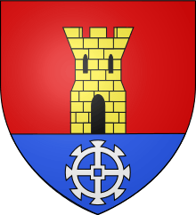 |
The arms of Bonsmoulins are blazoned : Gules, a tower Or open, pierced and masoned sable, issuant from a base azure charged with a millwheel argent. (possibly non-official) |
See also
References
| Wikimedia Commons has media related to Bonsmoulins. |
This article is issued from
Wikipedia.
The text is licensed under Creative Commons - Attribution - Sharealike.
Additional terms may apply for the media files.