Almenêches
| Almenêches | ||
|---|---|---|
| Commune | ||
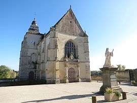 The church in Almenêches | ||
| ||
 Almenêches Location within Normandy region  Almenêches | ||
| Coordinates: 48°41′54″N 0°06′39″E / 48.6983°N 0.1108°ECoordinates: 48°41′54″N 0°06′39″E / 48.6983°N 0.1108°E | ||
| Country | France | |
| Region | Normandy | |
| Department | Orne | |
| Arrondissement | Alençon | |
| Canton | Sées | |
| Intercommunality | Communauté de communes du Pays de Mortrée | |
| Government | ||
| • Mayor (2014-2020) | Paul Vinet | |
| Area1 | 20.27 km2 (7.83 sq mi) | |
| Population (2014)2 | 705 | |
| • Density | 35/km2 (90/sq mi) | |
| Time zone | UTC+1 (CET) | |
| • Summer (DST) | UTC+2 (CEST) | |
| INSEE/Postal code | 61002 /61570 | |
| Elevation |
158–247 m (518–810 ft) (avg. 171 m or 561 ft) | |
|
1 French Land Register data, which excludes lakes, ponds, glaciers > 1 km2 (0.386 sq mi or 247 acres) and river estuaries. 2 Population without double counting: residents of multiple communes (e.g., students and military personnel) only counted once. | ||
Almenêches is a commune in the Orne department in north-western France.
Population
The inhabitants are known as Almenéchois.[1]
| Historical population | ||
|---|---|---|
| Year | Pop. | ±% |
| 1865 | 853 | — |
| 1865 | 853 | +0.0% |
| 1962 | 611 | −28.4% |
| 1968 | 615 | +0.7% |
| 1975 | 516 | −16.1% |
| 1982 | 600 | +16.3% |
| 1990 | 660 | +10.0% |
| 1999 | 645 | −2.3% |
| 2005 | 687 | +6.5% |
| 2009 | 649 | −5.5% |
| 2012 | 689 | +6.2% |
Heraldry
.svg.png) |
The arms of Almenêches are blazoned : Azure, on a bend argent between an anchor and a mullet Or, 3 ermine spots (palewise) sable. |
See also
References
- ↑ Mairie d'Almenêches, Ouest-France.fr.
| Wikimedia Commons has media related to Almenêches. |
This article is issued from
Wikipedia.
The text is licensed under Creative Commons - Attribution - Sharealike.
Additional terms may apply for the media files.