Aubusson, Orne
| Aubusson | ||
|---|---|---|
| Commune | ||
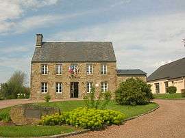 The town hall in Aubusson | ||
| ||
 Aubusson Location within Normandy region  Aubusson | ||
| Coordinates: 48°47′06″N 0°33′05″W / 48.785°N 0.5514°WCoordinates: 48°47′06″N 0°33′05″W / 48.785°N 0.5514°W | ||
| Country | France | |
| Region | Normandy | |
| Department | Orne | |
| Arrondissement | Argentan | |
| Canton | Flers-2 | |
| Intercommunality | Flers Agglo | |
| Government | ||
| • Mayor (2014-2020) | Sylvain Boulant | |
| Area1 | 3.90 km2 (1.51 sq mi) | |
| Population (2015)2 | 426 | |
| • Density | 110/km2 (280/sq mi) | |
| Time zone | UTC+1 (CET) | |
| • Summer (DST) | UTC+2 (CEST) | |
| INSEE/Postal code | 61011 /61100 | |
| Elevation |
168–272 m (551–892 ft) (avg. 264 m or 866 ft) | |
|
1 French Land Register data, which excludes lakes, ponds, glaciers > 1 km2 (0.386 sq mi or 247 acres) and river estuaries. 2 Population without double counting: residents of multiple communes (e.g., students and military personnel) only counted once. | ||
.svg.png)
Aubusson, Orne is a commune in the Orne department in northwestern France.
Population
| Historical population | ||
|---|---|---|
| Year | Pop. | ±% |
| 1793 | 389 | — |
| 1800 | 363 | −6.7% |
| 1806 | 382 | +5.2% |
| 1821 | 435 | +13.9% |
| 1831 | 534 | +22.8% |
| 1836 | 603 | +12.9% |
| 1841 | 601 | −0.3% |
| 1846 | 567 | −5.7% |
| 1851 | 559 | −1.4% |
| 1856 | 548 | −2.0% |
| 1861 | 542 | −1.1% |
| 1866 | 521 | −3.9% |
| 1872 | 528 | +1.3% |
| 1876 | 511 | −3.2% |
| 1881 | 418 | −18.2% |
| 1886 | 410 | −1.9% |
| 1891 | 408 | −0.5% |
| 1896 | 290 | −28.9% |
| 1901 | 275 | −5.2% |
| 1906 | 234 | −14.9% |
| 1911 | 214 | −8.5% |
| 1921 | 188 | −12.1% |
| 1926 | 203 | +8.0% |
| 1931 | 201 | −1.0% |
| 1936 | 212 | +5.5% |
| 1946 | 183 | −13.7% |
| 1954 | 180 | −1.6% |
| 1962 | 186 | +3.3% |
| 1968 | 189 | +1.6% |
| 1975 | 221 | +16.9% |
| 1982 | 314 | +42.1% |
| 1990 | 329 | +4.8% |
| 1999 | 335 | +1.8% |
| 2009 | 417 | +24.5% |
| 2015 | 426 | +2.2% |
See also
References
| Wikimedia Commons has media related to Aubusson (Orne). |
This article is issued from
Wikipedia.
The text is licensed under Creative Commons - Attribution - Sharealike.
Additional terms may apply for the media files.