Le Cercueil
| Le Cercueil | |
|---|---|
| Commune | |
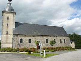 The church in Le Cercueil | |
 Le Cercueil Location within Normandy region  Le Cercueil | |
| Coordinates: 48°35′52″N 0°01′26″E / 48.5978°N 0.0239°ECoordinates: 48°35′52″N 0°01′26″E / 48.5978°N 0.0239°E | |
| Country | France |
| Region | Normandy |
| Department | Orne |
| Arrondissement | Alençon |
| Canton | Sées |
| Intercommunality | Communauté de communes du Pays de Mortrée |
| Government | |
| • Mayor (2008–2014) | Stelliane Bettefort |
| Area1 | 13.23 km2 (5.11 sq mi) |
| Population (2006)2 | 148 |
| • Density | 11/km2 (29/sq mi) |
| Time zone | UTC+1 (CET) |
| • Summer (DST) | UTC+2 (CEST) |
| INSEE/Postal code | 61076 /61500 |
| Elevation |
232–373 m (761–1,224 ft) (avg. 363 m or 1,191 ft) |
|
1 French Land Register data, which excludes lakes, ponds, glaciers > 1 km2 (0.386 sq mi or 247 acres) and river estuaries. 2 Population without double counting: residents of multiple communes (e.g., students and military personnel) only counted once. | |
Le Cercueil is a commune in the Orne department in north-western France.
See also
References
| Wikimedia Commons has media related to Le Cercueil. |
This article is issued from
Wikipedia.
The text is licensed under Creative Commons - Attribution - Sharealike.
Additional terms may apply for the media files.