Le Chalange
| Le Chalange | |
|---|---|
| Commune | |
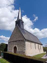 The church in Le Chalange | |
 Le Chalange Location within Normandy region  Le Chalange | |
| Coordinates: 48°35′39″N 0°18′50″E / 48.5942°N 0.3139°ECoordinates: 48°35′39″N 0°18′50″E / 48.5942°N 0.3139°E | |
| Country | France |
| Region | Normandy |
| Department | Orne |
| Arrondissement | Alençon |
| Canton | Radon |
| Intercommunality | Communauté de communes du Pays de Courtomer |
| Government | |
| • Mayor (2008–2014) | Pascal Houssin |
| Area1 | 6.27 km2 (2.42 sq mi) |
| Population (2006)2 | 72 |
| • Density | 11/km2 (30/sq mi) |
| Time zone | UTC+1 (CET) |
| • Summer (DST) | UTC+2 (CEST) |
| INSEE/Postal code | 61082 /61390 |
| Elevation |
159–231 m (522–758 ft) (avg. 177 m or 581 ft) |
|
1 French Land Register data, which excludes lakes, ponds, glaciers > 1 km2 (0.386 sq mi or 247 acres) and river estuaries. 2 Population without double counting: residents of multiple communes (e.g., students and military personnel) only counted once. | |
Le Chalange is a commune in the Orne department in north-western France.
See also
References
| Wikimedia Commons has media related to Le Chalange. |
This article is issued from
Wikipedia.
The text is licensed under Creative Commons - Attribution - Sharealike.
Additional terms may apply for the media files.