Wani, Yavatmal
| Wani Wun[1] | |
|---|---|
| City | |
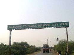 Entrance | |
| Nickname(s): Black Diamond City | |
 Wani Location in Maharashtra, India | |
| Coordinates: 20°03′20″N 78°57′12″E / 20.05556°N 78.95333°ECoordinates: 20°03′20″N 78°57′12″E / 20.05556°N 78.95333°E | |
| Country |
|
| State |
|
| Region | Vidarbha |
| Division | Amravati |
| District | Yavatmal |
| Government | |
| • Type | Municipal Council |
| • Body | Wani Municipal Council |
| • MP | Hansraj Ahir |
| • MLA | Sanjivreddy Bodkurwar |
| • Mayor | Tarendra Borde |
| Elevation | 228 m (748 ft) |
| Population (2011)[2] | |
| • Total |
City :58,840 Taluka :213,668 |
| • Rank | Yavatmal : 3rd |
| Languages | |
| • Official | Marathi |
| Time zone | UTC+5:30 (IST) |
| PIN | 445304 |
| Telephone Code | 07239 |
| Vehicle registration | MH29 |
| Website | www.yavatmal.nic.in/wani |
Wani (![]()
History
In earlier times, Wani was known as 'Wun'. Wani was a district headquarters in Berar Province during British Raj. Later on Wani became a taluka with Yavatmal as district head.
Demographics
As of the 2011 census of India, Wani had a population of 58,840 excluding outer part of the city.Villages like Ganeshpur,Chikhalgaon,Waghdara,Lalguda are in city boundaries but population is not included in the city population. Population increases near to one lakh as we include those villages. Males constituted 51% of the population and females 49%. Wani had an average literacy rate of 74%, higher than the national average of 59.5%: male literacy was 80%, and female literacy was 68%. In 2011 in Wani, 13% of the population was under 6 years of age.
Geography
The distance between district head Yavatmal and Wani is about 113 km (70 mi), where as the winter capital of Maharashtra Nagpur is about 132 km (82 mi). The adjacent district head Chandrapur is about 51 km (32 mi) away from Wani.
Coal Mining and Economy
Western Coalfields Ltd., A subsidiary of Coal India Ltd. has a coal mining area - Wani North Area in the surroundings of Wani city. There are coal mines like Ukni, Pimpalgaon, Junad, Kolarpimpri, Rajur, Kumbarkhani, Ghonsa and some new upcoming mining projects near the city.
The economy of the town is mostly driven by agriculture and mining businesses in the surrounding area.
The town received the name "Black Diamond City" due to the huge coal deposits and many coal mines in the adjacent area.
Limestone is also quarried in the area.
The principal crops are cotton and soyabeans.
City is also known for its shopping markets and has a flourishing trader's community.
Education
Schools
- Shikshan Prasarak Mandal High School & Junior College
- Vivekanand Vidyalaya
- Wani Public School and Junior College
- Adarsh High School
- Lions English Medium High School & Junior College
- Swarnleela International School
- Janata High School
- Macaroon Students Academy
- Smt.Nusabai Chopane Vidyalaya
- Z.P.High School
- KIDZ International School
- Sunrise Convent School
- Santaji English Medium School
- Dreamz Play School
- Rajshri Shahu Maharaj Hindi Vidhalaya
- Hello Kids International (Play School)
- Scholars International School
Colleges
- Lokmanya Tilak Mahavidyalaya, Wani
- Sushganga Polytechnic College, Naigaon
- Balaji Polytechnic College, Sawarla
- Shikshan Prasarak Mandal Institute of Pharmacy, Wani
- Shri.Jagannath Maharaj College, Wani
- Industrial Training Institute(ITI), Wani
- SCSMSS-Private Industrial Training Center, Wani.
- SCSMSS Institute of Pharmacy
Religious Places
Temples
 Ranganatha-Swami Temple view
- Shri Ranganatha Swami Mandir
- Shri Jaitai Mata Mandir
- Shri Jod-Mahadev Mandir
- Shri Jain Sthanak
- Shri Sambhavnath Jain Mandir
- Shri Kalaram Mandir
- Shri Sai mandir
- Shri Jagannath Maharaj Mandir
- Shri Sai Darbar
- Hanuman Mandir
- Mahakali Mata Mandir
- Santdham
- Ganpati Mandir
- Shiv Mandir
- Shani Mandir
- Shri Ram Mandir
- Vithhal Mandir
- Sant Gadge Baba Mandir
- Jata Shankar Mandir
- Gajanan Maharaj Mandir
- Datta Mandir
- Jagdamba Mandir
Mosques
- Jama Masjid
- Masjid E Hayat
- Nagina Masjid
- Madina Masjid
- Aqsa Masjid
- Al Raza Masjid
Gurudwara
- Sindhi Gurudwara
Churches
- Free Methodist Church
- New Methodist Church
Transport
Road
Highways
| State Highway No. | Route |
|---|---|
| Maharashtra - Madhya Pradesh border - Paratwada - Amravati - Yavatmal - Wani - Chandrapur | |
| MH SH 233 | Chimur - Warora - Wani - Rajani - Kelapur - Parwa |
| MH SH 236 | Sangvi on MH SH 212 - Ner - Babhulgaon - Kalamb - Ralegaon - Pimpalapur - Wani - Shivpur - Mohada - Kurai |
Wani Bus Station
Wani Bus Station works under Maharashtra State Road Transport Corporation MSRTC.
It includes 12 Platforms, Canteen, Temple, Garden, Parking Lout, Bus Depo and Diesel Pump.
- Ordinary Express
Wani is connected with major cities like Yavatmal, Nagpur, Pune, Aurangabad, Adilabad, Akola, Amravati, Chandrapur, Pusad, Washim, Gadchiroli, Darwha, Digras, Ner by MSRTC buses.
- Local Express
Local buses are connected to nearby towns such as Maregaon, Pandharkawda, Korpana and several villages.
Travels
Most of the private travels travel to Nagpur and other than that are Pune, Yavatmal and Chandrapur.
Travel agencies in Wani:
- Yash Travels
- Dhanashree Travels
- Chintamani Travels
Local Transport
Auto rickshaws are the only public transport in the city.
Railway
Wani is a regular type railway station, under Nagpur division of Central Railway.
It has one platform, with single electrified line.
- Nandigram Express
Daily train available for Nagpur, Mumbai, Wardha, Nanded and other cities.
It runs simultaneously from Mumbai to Nagpur.
- Transport
Trains heavily transport coal and other products are also loaded.
Population
Town/Cities
| # | Town/Cities | Population |
|---|---|---|
| 1 | Wani Municipal Council | 58,840 |
| 2 | Rajur Census Town | 10,692 |
Villages
| # | Village | Population |
|---|---|---|
| 1 | Aheri | 1,349 |
| 2 | Amlon | 472 |
| 3 | Babapur | 906 |
| 4 | Belora | 1,361 |
| 5 | Besa | 569 |
| 6 | Bhalar | 1,799 |
| 7 | Bhandewada | 1,096 |
| 8 | Bhurki | 510 |
| 9 | Bodad Bk. | 316 |
| 10 | Borda | 2,127 |
| 11 | Borgaon | 585 |
| 12 | Borgoan | 1,099 |
| 13 | Bori | 202 |
| 14 | Bramhani | 810 |
| 15 | Chanakha | 510 |
| 16 | Chargaon | 873 |
| 17 | Chendkapur | 357 |
| 18 | Chikhalgaon | 9,918 |
| 19 | Chikhali | 370 |
| 20 | Chilai | 549 |
| 21 | Chincholi | 307 |
| 22 | Dahegaon | 124 |
| 23 | Dahegaon | 1,339 |
| 24 | Deurwada | 232 |
| 25 | Dhabapur | 8 |
| 26 | Dhakori | 857 |
| 27 | Dhandir | 118 |
| 28 | Dhoptala | 239 |
| 29 | Dhunki | 502 |
| 30 | Dongargaon | 526 |
| 31 | Dorli | 724 |
| 32 | Fulora | 1,087 |
| 33 | Gadeghat | 245 |
| 34 | Ganeshpur | 1,942 |
| 35 | Ghonsa | 2,713 |
| 36 | Godgaon | 510 |
| 37 | Gopalpur | 320 |
| 38 | Gopalpur | 318 |
| 39 | Gowari | 444 |
| 40 | Gowari | 228 |
| 41 | Hiwardhara | 298 |
| 42 | Injasan | 481 |
| 43 | Jugad | 186 |
| 44 | Junada | 307 |
| 45 | Kalmana Bk. | 856 |
| 46 | Kalmana Kh | 356 |
| 47 | Kawadshi | 568 |
| 48 | Kayar | 2,730 |
| 49 | Keshav Nagar | 347 |
| 50 | Kesurli | 671 |
| 51 | Khandla | 976 |
| 52 | Kolera | 668 |
| 53 | Kolgaon | 859 |
| 54 | Kona | 1,194 |
| 55 | Korambhi | 493 |
| 56 | Krishnanpur | 1,069 |
| 57 | Kumbhari | 6 |
| 58 | Kumbharkhani | 238 |
| 59 | Kundra | 767 |
| 60 | Kurai | 1,567 |
| 61 | Kurli | 938 |
| 62 | Lalguda | 3,904 |
| 63 | Lathi | 607 |
| 64 | Mahankalpur | 573 |
| 65 | Majra | 551 |
| 66 | Malegaon | 18 |
| 67 | Mandar | 2,286 |
| 68 | Manki | 1,427 |
| 69 | Maregaon | 1,222 |
| 70 | Matholi | 1,964 |
| 71 | Mendholi | 1,609 |
| 72 | Mohada | 2,003 |
| 73 | Mohorli | 1,506 |
| 74 | Mungoli | 705 |
| 75 | Murdhoni | 1,549 |
| 76 | Murti | 238 |
| 77 | Nagala | 29 |
| 78 | Naigaon Bk. | 1,761 |
| 79 | Naigaon Kh | 1,125 |
| 80 | Nandepera | 2,407 |
| 81 | Nawargaon | 1,006 |
| 82 | Nawegaon | 1,909 |
| 83 | Nerad | 1,252 |
| 84 | Nilapur | 703 |
| 85 | Niljai | 191 |
| 86 | Nimbala | 764 |
| 87 | Nimbala Bk. | 649 |
| 88 | Niwali | 877 |
| 89 | Palsoni | 1,720 |
| 90 | Paramdoh | 731 |
| 91 | Parsoda | 303 |
| 92 | Parsoda | 545 |
| 93 | Patharpur | 753 |
| 94 | Pathri | 303 |
| 95 | Petur | 1,072 |
| 96 | Pimpalgaon | 470 |
| 97 | Pimpari | 559 |
| 98 | Pimpri | 1,110 |
| 99 | Pohana | 277 |
| 100 | Punvat | 2,407 |
| 101 | Purad | 1,336 |
| 102 | Purad | 1,019 |
| 103 | Rangana | 918 |
| 104 | Rasa | 2,567 |
| 105 | Sakhara | 927 |
| 106 | Sakhara | 2,243 |
| 107 | Sawangi | 1,044 |
| 108 | Sawarla | 977 |
| 109 | Shelu Bk | 847 |
| 110 | Shelu Kh | 924 |
| 111 | Shewala | 219 |
| 112 | Shindola | 2,057 |
| 113 | Shirgiri | 78 |
| 114 | Shirpur | 2,804 |
| 115 | Shivni | 800 |
| 116 | Somnala | 729 |
| 117 | Sonapur | 474 |
| 118 | Sonegaon | 1,147 |
| 119 | Suknegaon | 1,475 |
| 120 | Takli | 329 |
| 121 | Taroda | 2,910 |
| 122 | Tejapur | 1,876 |
| 123 | Ukani | 2,275 |
| 124 | Umari | 871 |
| 125 | Virkund | 482 |
| 126 | Vithalnagar | 464 |
| 127 | Wadgaon | 88 |
| 128 | Wadgaon Tip | 615 |
| 129 | Wadhona Pilki | 448 |
| 130 | Wadjapur | 555 |
| 131 | Wagdara | 2,777 |
| 132 | Wanjari | 2,168 |
| 133 | Wargaon | 759 |
| 134 | Warzadi | 553 |
| 135 | Welabai | 1,632 |
| 136 | Welhala | 3,255 |
| 137 | Yenad | 734 |
| 138 | Yenak | 1,424 |
| 139 | Zarpat | 492 |
| 140 | Zola | 623 |
ref:www.census2011.co.in
Languages
Marathi language is the most used language, among few other languages including Hindi, Sindhi ,Marwadi, Punjabi, Telugu, Urdu are used.
References
- ↑ Wūn (Variant - V) at GEOnet Names Server, United States National Geospatial-Intelligence Agency
- ↑ "Maharastra, Yavatmal, Wani Subdistrict, Wani (M Cl)". The Registrar General & Census Commissioner, India. 2011. Archived from the original on 28 July 2014.
- ↑ Wani (Approved - N) at GEOnet Names Server, United States National Geospatial-Intelligence Agency
Places adjacent to Wani, Yavatmal | |
|---|---|
Yavatmal district topics | ||
|---|---|---|
| History | 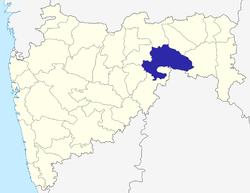 | |
| Geography | ||
| Cities and towns | ||
| Transport | ||
| Culture | ||
| Lok Sabha constituencies | ||
| Vidhan Sabha constituencies | ||
Major villages of Yavatmal district | |
|---|---|
|