Manbhum
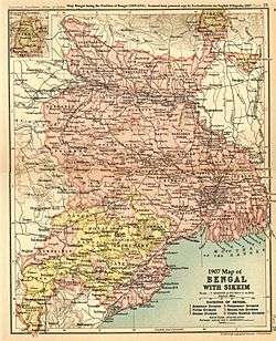
Manbhum District was one of the districts of the East India during the British Raj.[1] After India’s independence, the district became a part of Bihar State. Upon re-organization of the Indian states in the mid-1950s, present Purulia district was carved out of the district of Manbhum and became a part of the West Bengal; the remaining part of Manbhum district was kept with Bihar state and became part of Dhanbad district.[2]
Manbhum region has thick forests, with good mineral resources, and has a mixed demographic profile with people from different religious and social groups, including adivasis, particularly the Santals and the Mundas.[1]
History behind Manbhum
At the time of eighth century, there was an epistle Sanskrit poem engraved on Dudhpani Mountain, situated in Hazaribag. That epistle or story was related to three brothers named Udaiman, Dhoutaman and Ajitman, who went to Tamralipta from Ayodhya for their trading purpose. After earning a lot of money, they were coming back to their place. After travelling long distance, they were taking rest in Bhramarshalmli village and at that time, the king of Magadh, named Adisingha used to set out on a journey to hunt elephant. He was looking for Avalgak or Avalgan and villagers did not understand what that object is. But, Udaiman bought it to the king and the king was so pleased that he gave one village of that particular area to Udaiman. Villagers honoured him as their king and Adisingha gave another two villages to Dhoutaman and Ajitman too. After that, Manbhum was emerged from the name of Man Kings (Udaiman, Dhoutaman, AjitmanManbhum, where „bhum‟ means land). From the name of Manbhum, Purulia Chhow is also known as Manbhum Chhow because, Purulia was one of the part of Manbhum.[3]
See also
References
- 1 2

- ↑ History of Manbhum
- ↑ http://www.journalijar.com/article/20590/societal-representation-of-manbhum-chhow-a-case-of-chhow-mask-makers-of-charida-village,-purulia-district,-west-bengal/
Further reading
- Coupland, H. Bengal District Gazetteers Manbhum. The Bengal Secretariat Book Depot Calcutta. Retrieved 24 December 2016.
- Saha, Biswajeet (29 October 2017). "SOCIETAL REPRESENTATION OF MANBHUM CHHOW A CASE OF CHHOW MASK MAKERS OF CHARIDA VILLAGE, PURULIA DISTRICT, WEST BENGAL". International Journal of Advanced Research. 5 (10): 1731. doi:10.21474/IJAR01/5696. Retrieved 19 January 2018.
Coordinates: 23°20′N 86°22′E / 23.333°N 86.367°E