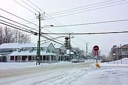
Saint-Zotique, Quebec
| Saint-Zotique | |
|---|---|
| Municipality | |
 | |
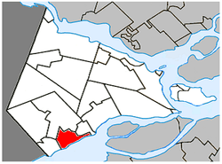 Location within Vaudreuil-Soulanges RCM | |
 St-Zotique Location in southern Quebec | |
| Coordinates: 45°15′N 74°15′W / 45.25°N 74.25°WCoordinates: 45°15′N 74°15′W / 45.25°N 74.25°W[1] | |
| Country |
|
| Province |
|
| Region | Montérégie |
| RCM | Vaudreuil-Soulanges |
| Constituted | May 27, 1967 |
| Government[2][3] | |
| • Mayor | Yvon Chiasson |
| • Federal riding | Salaberry—Suroît |
| • Prov. riding | Soulanges |
| Area[2][4] | |
| • Total | 50.30 km2 (19.42 sq mi) |
| • Land | 25.19 km2 (9.73 sq mi) |
| Population (2011)[4] | |
| • Total | 6,773 |
| • Density | 268.8/km2 (696/sq mi) |
| • Pop 2006-2011 |
|
| • Dwellings | 2,893 |
| Time zone | UTC−5 (EST) |
| • Summer (DST) | UTC−4 (EDT) |
| Postal code(s) | J0P 1Z0 |
| Area code(s) | 450 and 579 |
| Highways |
|
| Website |
www |
Saint-Zotique (/ˌsɛ̃zɔ'tsɪk/) is a municipality located within the Vaudreuil-Soulanges Regional County Municipality in the Montérégie region located about 45 minutes west of Montreal, Quebec, Canada. It is named for Saint Zoticus of Comana.
The municipality resides on the north shore of the Saint Lawrence River and Lake Saint Francis and along the Quebec City–Windsor Corridor, the most populated area in Canada.
History
The first economic activities in the region started in the mid-18th century with forest exploitation and agriculture. The place was first named "Concession-du-Lac" and "Lac-Saint-François" after the adjacent lake. Subsequently, it was also known as "Longueuil-sur-le-Lac" (because it was part of the seigneury of New Longueuil, and "Moulin-Biron" (named after the owner of the first sawmill built near the wharf).[5]
Saint-Zotique officially became parish near 1849 when it was separated from the parish of Saint-Polycarpe located a few kilometers to the north. In 1854, its post office opened, and a year later in 1855, the Parish Municipality of Saint-Zotique was formed.[5]
In 1913, the village itself split off from the parish municipality to form the Village Municipality of Saint-Zotique, and eventually the two municipalities merged again to form a new village municipality in 1967. On April 4, 2009, it changed its status to just municipality.[5]
Demographics
Population
| Canada census – Saint-Zotique, Quebec community profile | |||
|---|---|---|---|
| 2011 | 2006 | ||
| Population: | 6,773 (+29.0% from 2006) | 5,251 (+26.3% from 2001) | |
| Land area: | 25.19 km2 (9.73 sq mi) | 25.19 km2 (9.73 sq mi) | |
| Population density: | 268.8/km2 (696/sq mi) | 208.4/km2 (540/sq mi) | |
| Median age: | 37.9 (M: 38.0, F: 37.9) | 38.8 (M: 39.1, F: 38.5) | |
| Total private dwellings: | 2,893 | 2,267 | |
| Median household income: | $66,171 | $59,807 | |
| References: 2011[4] 2006[6] earlier[7] | |||
| Historical Census Data - Saint-Zotique, Quebec[8] | ||
|---|---|---|
| Year | Pop. | ±% |
| 1991 | 2,515 | — |
| 1996 | 3,683 | +46.4% |
| 2001 | 4,158 | +12.9% |
| 2006 | 5,251 | +26.3% |
| 2011 | 6,773 | +29.0% |
| 2016 | 7,934 | +17.1% |
Language
| Canada Census Mother Tongue - Saint-Zotique, Quebec[8] | ||||||||||||||||||
|---|---|---|---|---|---|---|---|---|---|---|---|---|---|---|---|---|---|---|
| Census | Total | French |
English |
French & English |
Other | |||||||||||||
| Year | Responses | Count | Trend | Pop % | Count | Trend | Pop % | Count | Trend | Pop % | Count | Trend | Pop % | |||||
2016 |
7,935 |
7,335 | 92.44% | 345 | 4.35% | 65 | 0.82% | 165 | 2.08% | |||||||||
2011 |
6,760 |
6,295 | 93.12% | 300 | 4.44% | 65 | 0.96% | 100 | 1.48% | |||||||||
2006 |
5,255 |
4,965 | 94.48% | 170 | 3.23% | 45 | 0.86% | 75 | 1.43% | |||||||||
2001 |
4,150 |
3,980 | 95.90% | 135 | 3.25% | 25 | 0.60% | 10 | 0.24% | |||||||||
1996 |
3,670 |
3,420 | n/a | 93.19% | 145 | n/a | 3.95% | 60 | n/a | 1.63% | 45 | n/a | 1.23% | |||||
Attractions
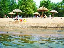
The town is home to a popular beach which can accommodate as many as 10,000 people. Located on Lac Saint-François, nautical sports are among the region's most popular activities and the town also has a golf course.[9]
Infrastructure
Transportation
Located on Route 338 and just south of Autoroute 20 near the Ontario-Quebec border, it is easily accessible from the busiest transportation corridor of the country with direct links to Montreal, Cornwall and Toronto.
Education
Commission Scolaire des Trois-Lacs operates Francophone schools.[10]
- École de la Riveraine
- École des Orioles
- École Saint-Zotique
- École Virginie-Roy
- 2e Avenue is zoned to École Léopold-Carrière in Les Coteaux[11]
Lester B. Pearson School Board operates Anglophone schools.[12]
- Soulanges Elementary School in Saint-Télesphore or Evergreen Elementary and Forest Hill Elementary (Junior Campus and Senior campus) in Saint-Lazare
See also
References
- ↑ Reference number 402430 of the Commission de toponymie du Québec (in French)
- 1 2 Ministère des Affaires municipales, des Régions et de l'Occupation du territoire: Saint-Zotique
- ↑ Parliament of Canada Federal Riding History: VAUDREUIL--SOULANGES (Quebec)
- 1 2 3 "2011 Community Profiles". Canada 2011 Census. Statistics Canada. July 5, 2013. Retrieved 2014-02-06.
- 1 2 3 "Fiche descriptive: Saint-Zotique". www.toponymie.gouv.qc.ca. Commission de toponymie du Québec. Retrieved 23 January 2018.
- ↑ "2006 Community Profiles". Canada 2006 Census. Statistics Canada. March 30, 2011. Retrieved 2014-02-06.
- ↑ "2001 Community Profiles". Canada 2001 Census. Statistics Canada. February 17, 2012.
- 1 2 Statistics Canada: 1996, 2001, 2006, 2011 census
- ↑ Saint-Zotique official website - Recreation Archived 18 September 2007 at the Wayback Machine.
- ↑ "Les écoles et les centres". Commission Scolaire des Trois-Lacs. Retrieved 18 January 2013.
- ↑ "Liste des bassins desservis par les écoles en 2017-2018." Commission Scolaire des Trois-Lacs. Retrieved on September 30, 2017.
- ↑ "School Board Map." Lester B. Pearson School Board. Retrieved on September 28, 2017.
External links
| Wikimedia Commons has media related to Saint-Zotique, Quebec. |
- Website of Saint-Zotique, Quebec (in French)
- Municipal Beach Website (in French)
- Map of the Vaudreuil-Soulanges region
Places adjacent to Saint-Zotique, Quebec | |
|---|---|
| Cities & towns | |
|---|---|
| Municipalities | |
| Villages | |
| |