Saint-Joseph-du-Lac, Quebec
| Saint-Joseph-du-Lac | |
|---|---|
| Municipality | |
 | |
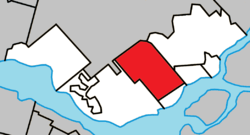 Location within Deux-Montagnes RCM. | |
 St-Joseph-du-Lac Location in central Quebec. | |
| Coordinates: 45°32′N 74°00′W / 45.533°N 74.000°WCoordinates: 45°32′N 74°00′W / 45.533°N 74.000°W[1] | |
| Country |
|
| Province |
|
| Region | Laurentides |
| RCM | Deux-Montagnes |
| Constituted | July 1, 1855 |
| Government[2] | |
| • Mayor | Alain Guindon |
| • Federal riding | Mirabel |
| • Prov. riding | Mirabel |
| Area[2][3] | |
| • Total | 41.80 km2 (16.14 sq mi) |
| • Land | 41.38 km2 (15.98 sq mi) |
| Population (2011)[3] | |
| • Total | 6,195 |
| • Density | 149.7/km2 (388/sq mi) |
| • Pop 2006-2011 |
|
| • Dwellings | 2,325 |
| Time zone | UTC−5 (EST) |
| • Summer (DST) | UTC−4 (EDT) |
| Postal code(s) | J0N 1M0 |
| Area code(s) | 450 and 579 |
| Highways |
|
| Website |
www |
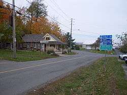
Saint-Joseph-du-Lac is a municipality in the Laurentides region of Quebec, Canada, part of the Deux-Montagnes Regional County Municipality.
History
The territory of the municipality of Saint-Joseph-du-Lac was part of the Lac des Deux-Montagnes Seigneury for over a hundred years. This seigneury was granted on October 17, 1717, to the Sulpician Order of the Ecclesiastical Seminary of St. Sulpice in Paris, who already were lords of the Island of Montreal. In 1783, the Sulpicians signed a total of 25 concessions. Over the next ten years, from 1782 to 1793, 81 lands on the Saint-Joseph side were granted to settlers. In 1803, Côte Saint-Joseph Road was extended northward to allow settlers to travel to Saint-Benoît.[4]
Around 1850, the inhabitants of the Saint-Joseph Concession started the process to obtain a parish, which was formally established in 1853. Two years later on July 1, 1855, the Parish Municipality of Saint-Joseph was formed.[5] It extended over a length of 10 kilometres (6.2 mi) from Lake of Two Mountains to the limits of Saint-Benoît Parish, and a width of 3.5 kilometres (2.2 mi). The population at that time was 1020 people in about 180 families.[4]
In 1856, the post office opened, being identified as Saint-Joseph-du-Lac in order to distinguish it from the many other locations called Saint-Joseph. In time this name also came to be used for the entire municipality.[5]
In 1953, the southern portion of the municipality along Lake of Two Mountains separated from Saint-Joseph-du-Lac and became the Village Municipality of Pointe-Calumet. [6]
In the 1970s, Autoroute 640 was built through Saint-Joseph-du-Lac, putting economic pressure on the municipality. This led to new housing developments for Montreal commuters and a noticeable growth in population that had previously been stable for nearly 80 years. During the following two decades, several more new developments were built, including the Paquin, Brunet, and Parc Sectors.[4]
Demographics
Population trend:[7]
- Population in 2011: 6195 (2006 to 2011 population change: 24.9%)
- Population in 2006: 4958 (2001 to 2006 population change: 1.6%)
- Population in 2001: 4882
- Population in 1996: 4930
- Population in 1991: 4312
Private dwellings occupied by usual residents: 2268 (total dwellings: 2325)
Mother tongue:
- English as first language: 3.5%
- French as first language: 93.7%
- English and French as first language: 1.1%
- Other as first language: 1.6%
Education
The Commission scolaire de la Seigneurie-des-Mille-Îles (CSSMI) operates Francophone public schools.[8]
Secondary students are zoned to École secondaire d'Oka in Oka.[11]
The Sir Wilfrid Laurier School Board is the area English school board. Several Anglophone schools in Deux-Montagnes serve this community: Mountainview Elementary School,[12] Saint Jude Elementary School,[13] and Lake of Two Mountains High School.[14]
See also
References
- ↑ Reference number 333322 of the Commission de toponymie du Québec (in French)
- 1 2 Geographic code 72025 in the official Répertoire des municipalités (in French)
- 1 2 "(Code 2472025) Census Profile". 2011 census. Statistics Canada. 2012.
- 1 2 3 "Découvrir Saint-Joseph - Histoire" (in French). Municipalité de Saint-Joseph-du-Lac. Retrieved 2009-03-12.
- 1 2 "Saint-Joseph-du-Lac (Municipalité)" (in French). Commission de toponymie du Québec. Retrieved 2009-03-12.
- ↑ "Pointe-Calumet (Municipalité)" (in French). Commission de toponymie du Québec. Retrieved 2009-03-12.
- ↑ Statistics Canada: 1996, 2001, 2006, 2011 census
- ↑ "Admission et inscription Archived 2015-01-31 at the Wayback Machine.." Commission scolaire de la Seigneurie-des-Mille-Iles. Retrieved on December 7, 2014. "La Commission scolaire de la Seigneurie-des-Mille-Iles (CSSMI) offre ses services aux résidents des municipalités de : Blainville, Boisbriand, Bois-des-Filion, Deux-Montagnes, Lorraine, Mirabel (Saint-Augustin, Saint-Benoît, Sainte-Scholastique et secteur du Domaine-Vert), Oka, Pointe-Calumet, Rosemère, Sainte-Anne-des-Plaines, Sainte-Marthe-sur-le-Lac, Sainte-Thérèse, Saint-Eustache, Saint-Joseph-du-Lac, Saint-Placide et Terrebonne Ouest."
- ↑ "Rose-des-Vents." Commission scolaire de la Seigneurie-des-Mille-Îles. Retrieved on September 20, 2017.
- ↑ "du Grand Pommier." Commission scolaire de la Seigneurie-des-Mille-Îles. Retrieved on September 22, 2017.
- ↑ "Répertoire des aires de desserte par ville 2017 - 2018 (Généré le 21/9/2017) Ville Saint-Joseph-du-Lac." Commission scolaire de la Seigneurie-des-Mille-Îles. Retrieved on September 22, 2017.
- ↑ "Mountainview Elementary Zone Archived December 11, 2014, at the Wayback Machine.." Sir Wilfrid Laurier School Board. Retrieved on December 8, 2014.
- ↑ "Saint Jude Elementary School Zone Map Archived December 11, 2014, at the Wayback Machine.." Sir Wilfrid Laurier School Board. Retrieved on December 8, 2014.
- ↑ "Overview." Lake of Two Mountains High School. Retrieved on December 8, 2014.
External links

Adjacent Municipal Subdivisions | ||||||||||
|---|---|---|---|---|---|---|---|---|---|---|
| ||||||||||
| Cities & Towns | |
|---|---|
| Municipalities | |
| |