Saint-Sulpice, Quebec
| Saint-Sulpice | |
|---|---|
| Parish municipality | |
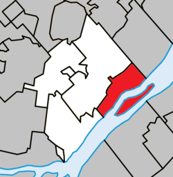 Location within L'Assomption RCM. | |
 Saint-Sulpice Location in central Quebec. | |
| Coordinates: 45°50′N 73°21′W / 45.833°N 73.350°WCoordinates: 45°50′N 73°21′W / 45.833°N 73.350°W[1] | |
| Country |
|
| Province |
|
| Region | Lanaudière |
| RCM | L'Assomption |
| Settled | 1680 |
| Constituted | July 1, 1855 |
| Government[2] | |
| • Mayor | Poste vacant |
| • Federal riding | Repentigny |
| • Prov. riding | Repentigny |
| Area[2][3] | |
| • Total | 52.80 km2 (20.39 sq mi) |
| • Land | 36.38 km2 (14.05 sq mi) |
| Population (2011)[3] | |
| • Total | 3,273 |
| • Density | 90.0/km2 (233/sq mi) |
| • Pop 2006–2011 |
|
| • Dwellings | 1,375 |
| Time zone | UTC−5 (EST) |
| • Summer (DST) | UTC−4 (EDT) |
| Postal code(s) | J5W 1G1 |
| Area code(s) | 450 and 579 |
| Highways |
|
| Website |
www.municipalite saintsulpice.com |
Saint-Sulpice is a municipality in the Lanaudière region of Quebec, Canada, part of the L'Assomption Regional County Municipality. It is located on the north shore of the Saint Lawrence River and includes most of Verchères Islands.
History
From 1680 onwards, French settlers colonized this area, clearing the land for cultivation. At that time it was part of the Saint-Sulpice Seignory that was owned by the Society of Saint-Sulpice. In 1640 the seignory granted a concession to Pierre Chevrier, Baron of Fancamp, and to Jérôme Le Royer.[1]
In 1706, the settlement was assigned its first pastor and in 1715, it had the region's only flour mill in operation. The Parish of Saint-Sulpice was formed in 1722, taking its name from the seignory. In 1845, the parish municipality was formed and in 1854, its post office opened.[1]
Demographics
Population
| Canada census – Saint-Sulpice, Quebec community profile | |||
|---|---|---|---|
| 2011 | 2006 | ||
| Population: | 3,273 (-1.8% from 2006) | 3,332 (-0.3% from 2001) | |
| Land area: | 36.38 km2 (14.05 sq mi) | 36.38 km2 (14.05 sq mi) | |
| Population density: | 90.0/km2 (233/sq mi) | 91.6/km2 (237/sq mi) | |
| Median age: | 41.3 (M: 40.9, F: 41.7) | 38.5 (M: 38.8, F: 38.2) | |
| Total private dwellings: | 1,375 | 1,288 | |
| Median household income: | $69,989 | $62,144 | |
| References: 2011[3] 2006[4] earlier[5] | |||
| Historical Census Data - Saint-Sulpice, Quebec[6] | ||||||||||||||||||||||||||
|---|---|---|---|---|---|---|---|---|---|---|---|---|---|---|---|---|---|---|---|---|---|---|---|---|---|---|
|
|
| ||||||||||||||||||||||||
Language
| Canada Census Mother Tongue - Saint-Sulpice, Quebec[6] | ||||||||||||||||||
|---|---|---|---|---|---|---|---|---|---|---|---|---|---|---|---|---|---|---|
| Census | Total | French |
English |
French & English |
Other | |||||||||||||
| Year | Responses | Count | Trend | Pop % | Count | Trend | Pop % | Count | Trend | Pop % | Count | Trend | Pop % | |||||
2011 |
3,255 |
3,140 | 96.47% | 35 | 1.07% | 15 | 0.46% | 65 | 2.00% | |||||||||
2006 |
3,315 |
3,225 | 97.29% | 15 | 0.45% | 25 | 0.75% | 50 | 1.51% | |||||||||
2001 |
3,335 |
3,270 | 98.05% | 10 | 0.30% | 0 | 0.00% | 55 | 1.65% | |||||||||
1996 |
3,280 |
3,205 | n/a | 97.71% | 35 | n/a | 1.07% | 15 | n/a | 0.46% | 25 | n/a | 0.76% | |||||
Education
The Sir Wilfrid Laurier School Board operates anglophone public schools, including:
- Joliette Elementary School in Saint-Charles-Borromée[7]
Sister city
- Saint-Jean-d'Angély (France)[8]
See also
References
- 1 2 3 "Saint-Sulpice (Municipalité de paroisse)" (in French). Commission de toponymie du Québec. Retrieved 2009-09-22.
- 1 2 Geographic code 60020 in the official Répertoire des municipalités (in French)
- 1 2 3 "2011 Community Profiles". Canada 2011 Census. Statistics Canada. July 5, 2013. Retrieved 2014-05-24.
- ↑ "2006 Community Profiles". Canada 2006 Census. Statistics Canada. March 30, 2011. Retrieved 2014-05-24.
- ↑ "2001 Community Profiles". Canada 2001 Census. Statistics Canada. February 17, 2012.
- 1 2 Statistics Canada: 1996, 2001, 2006, 2011 census
- ↑ "JOLIETTE ELEMENTARY ZONE." Sir Wilfrid Laurier School Board. Retrieved on September 17, 2017.
- ↑ https://www.municipalitesaintsulpice.com/bottin-des-organismes-municipaux/
Adjacent Municipal Subdivisions | |
|---|---|
| Cities/towns | |
|---|---|
| Municipalities | |
| |