Mont-Saint-Hilaire, Quebec
| Mont-Saint-Hilaire | |
|---|---|
| City | |
 | |
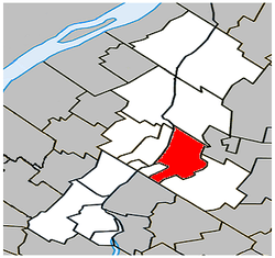 Location within La Vallée-du-Richelieu RCM. | |
 Mont-Saint-Hilaire Location in southern Quebec. | |
| Coordinates: 45°34′N 73°12′W / 45.567°N 73.200°WCoordinates: 45°34′N 73°12′W / 45.567°N 73.200°W[1] | |
| Country |
|
| Province |
|
| Region | Montérégie |
| RCM | La Vallée-du-Richelieu |
| Constituted | March 12, 1966 |
| Government[2][3] | |
| • Mayor | Yves Corriveau |
| • Federal riding | Beloeil—Chambly |
| • Prov. riding | Borduas |
| Area[2][4] | |
| • Total | 45.50 km2 (17.57 sq mi) |
| • Land | 44.29 km2 (17.10 sq mi) |
| Population (2011)[4] | |
| • Total | 18,200 |
| • Density | 410.9/km2 (1,064/sq mi) |
| • Pop 2006-2011 |
|
| • Dwellings | 7,406 |
| Time zone | UTC−5 (EST) |
| • Summer (DST) | UTC−4 (EDT) |
| Postal code(s) | J3H |
| Area code(s) | 450 and 579 |
| Highways |
|
| Website |
www |
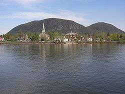
Mont-Saint-Hilaire (French pronunciation: [mɔ̃ sɛ̃ nilɛʁ]) is an off-island suburb of Montreal in southeastern Quebec, Canada, on the Richelieu River in the Regional County Municipality of La Vallée-du-Richelieu. The population as of the Canada 2011 Census was 18,200. The city is named after the Mont Saint-Hilaire.
A significant deposit of the semi-precious mineral sodalite is located near Mont-Saint-Hilaire.
History
Jean-Baptiste Hertel de Rouville was granted the seignory of the region in 1694.[5] By 1745 a mountain village had been formed with the first chapel being built in 1798 near the Richelieu River. Nearly twenty years later, in 1822, a ferry operating between Beloeil and Mont-Saint-Hilaire came into service. A bridge, enabling Beloeil and St. Hilaire to be connected by rail, was built in 1848 by the St. Lawrence and Atlantic Railway. The Campbell family, owners of the mountain after that of Rouville, sold the mountain to a British officer, Brigadier-General Andrew Gault, in whose ownership it remained for 45 years. Gault then bequeathed the mountain to McGill University before his death in 1958.
Demographics
PopulationPopulation trend:[6]
|
LanguageMother tongue language (2006)[7]
|
Transportation
Mont-Saint-Hilaire is served by the Mont-Saint-Hilaire commuter rail station on the Réseau de transport métropolitain's (RTM) Mont-Saint-Hilaire line. Local bus service is provided by the RTM's Vallée du Richelieu sector.
In 1864, Canada's worst rail disaster occurred here when a passenger train passed a red signal and fell off an open swing bridge into the Richelieu River, killing around 99 people.
Attractions
- The Gault Nature Reserve on Mont Saint-Hilaire includes over a thousand hectares of primeval forest. Owned by McGill University, the nature reserve is used for research and recreation.
- Le Musée des beaux-arts de Mont-Saint-Hilaire is the major art museum on the south shore of the Saint Lawrence River. It was founded in 1993 to promote the work of regional artists Jordi Bonet, Paul-Émile Borduas and Ozias Leduc.[8] Exhibitions also feature art from the area, such as Saint-Hilaire et les Automatistes in 1997, and Leduc, Borduas et le paysage de Saint-Hilaire in 2008, as well as other Quebec artists such as Jean-Paul Lemieux and Nancy Petry.[9]
- Art Station
- Art center Ozias Leduc
- Manoir Rouville-Campbell
- Saint-Hilaire church
Education
The South Shore Protestant Regional School Board previously served the municipality.[10]
See also
References
- ↑ Reference number 42205 of the Commission de toponymie du Québec (in French)
- 1 2 Ministère des Affaires municipales, des Régions et de l'Occupation du territoire: Mont-Saint-Hilaire
- ↑ Parliament of Canada Federal Riding History: CHAMBLY--BORDUAS (Quebec)
- 1 2 2011 Statistics Canada Census Profile: Mont-Saint-Hilaire, Quebec
- ↑ Charlotte Gray 'The Museum Called Canada: 25 Rooms of Wonder' Random House, 2004
- ↑ Statistics Canada: 1996, 2001, 2006, 2011 census
- ↑ 2006 Statistics Canada Community Profile: Mont-Saint-Hilaire, Quebec
- ↑ Le Musée des beaux-arts de Mont-Saint-Hilaire website
- ↑ Le Musée des beaux-arts de Mont-Saint-Hilaire website
- ↑ King, M.J. (Chairperson of the board). "South Shore Protestant Regional School Board" (St. Johns, PQ). The News and Eastern Townships Advocate. Volume 119, No. 5. Thursday December 16, 1965. p. 2. Retrieved from Google News on November 23, 2014.
External links
| Wikimedia Commons has media related to Mont-Saint-Hilaire (Quebec). |
Adjacent Municipal Subdivisions | |
|---|---|
| Cities | |
|---|---|
| Municipalities | |
| |