Pointe-Calumet, Quebec
| Pointe-Calumet | ||
|---|---|---|
| Municipality | ||
 | ||
| ||
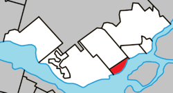 Location within Deux-Montagnes RCM | ||
 Pointe-Calumet Location in central Quebec | ||
| Coordinates: 45°30′N 73°58′W / 45.5°N 73.97°WCoordinates: 45°30′N 73°58′W / 45.5°N 73.97°W[1] | ||
| Country |
| |
| Province |
| |
| Region | Laurentides | |
| RCM | Deux-Montagnes | |
| Constituted | February 12, 1953 | |
| Government[2] | ||
| • Mayor | Sonia Fontaine | |
| • Federal riding | Mirabel | |
| • Prov. riding | Mirabel | |
| Area[2][3] | ||
| • Total | 11.60 km2 (4.48 sq mi) | |
| • Land | 4.63 km2 (1.79 sq mi) | |
| Population (2011)[3] | ||
| • Total | 6,396 | |
| • Density | 1,382.4/km2 (3,580/sq mi) | |
| • Pop 2006-2011 |
| |
| • Dwellings | 2,636 | |
| Time zone | UTC−5 (EST) | |
| • Summer (DST) | UTC−4 (EDT) | |
| Postal code(s) | J0N 1G0 | |
| Area code(s) | 450 and 579 | |
| Highways |
| |
| Website |
www | |

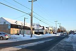
Pointe-Calumet is a municipality in the Canadian province of Quebec. The municipality is located within the Deux-Montagnes Regional County Municipality in the Laurentides region. It is situated about 30 minutes northwest of Montreal. Its population as of the 2006 Canadian Census is just over 6 000.
Geography
The town is located on the northern shore of the Ottawa River, the Rivière des Mille Îles and the Lake of Two Mountains which all joins the Saint Lawrence River to its south near the west island of Montreal.
Pointe-Calumet is accessible from the Greater Montreal Area and points east from Quebec Autoroute 640 that runs from Laval, Saint-Eustache, Terrebonne and Repentigny. Quebec Route 344 runs through the village and also links the northern Montreal suburbs as well as the Grenville area north of Hawkesbury, Ontario. It is also located nearby the Montreal commuter train that runs from downtown Montreal to nearby Deux-Montagnes.
The town is located within the provincial electoral district of Deux-Montagnes which also includes the municipality of the same name located to its east.
History
Pointe-Calumet was declared a municipality in 1952 after being part of the Saint-Joseph-du-Lac parish where about 30 families were living prior of being a municipality. However, with the presence of numerous beaches in the vicinity numerous visitors from the Montreal region were visiting the area during weekends.[4]
Demographics
Population trend:[5]
- Population in 2011: 6396 (2006 to 2011 population change: -2.7%)
- Population in 2006: 6574 (2001 to 2006 population change: 17.3%)
- Population in 2001: 5604
- Population in 1996: 5443
- Population in 1991: 4482
Private dwellings occupied by usual residents: 2539 (total dwellings: 2636)
Mother tongue:
- English as first language: 4%
- French as first language: 92.3%
- English and French as first language: 1.2%
- Other as first language: 2.5%
Tourist attractions
The town's major attraction is the Super Aqua Club, is one of the biggest waterparks in the province along with the Water Parks at Mont Saint-Sauveur. Opened in 1984, the park contains about 40 attractions. The Beach Club is today the main beach of the area.[6] The town is also located the Oka National Park situated about 10 kilometers west near the village of Oka.
Local government

Municipal council:
- Jacques Seguin, mayor (retired)
- Jean-Guy Lafaille, councilor (district 1)
- Denis Gravel, councilor (district 2)
- Alexander Tomeo, councilor (district 3)
- Robert Beauchamp, councilor (district 4)
- Normand Clermont, councilor (district 5)
- Marie-Claude Prud'Homme, councilor (district 6)
Education
The Commission scolaire de la Seigneurie-des-Mille-Îles (CSSMI) operates Francophone public schools.[7] The community is zoned to École des Perséides in Pointe-Calumet and École polyvalente Deux-Montagnes in Deux-Montagnes.[8]
The Sir Wilfrid Laurier School Board operates Anglophone schools. Lake of Two Mountains High School in Deux-Montagnes serves this community.[9] Mountainview Elementary School and Saint Jude Elementary School, both in Deux-Montagnes, also serve this community.[10][11]
See also
References
- ↑ Reference number 322547 of the Commission de toponymie du Québec (in French)
- 1 2 Geographic code 72020 in the official Répertoire des municipalités (in French)
- 1 2 "(Code 2472020) Census Profile". 2011 census. Statistics Canada. 2012.
- ↑ Municipalité Pointe-Calumet Archived 2008-05-07 at the Wayback Machine.
- ↑ Statistics Canada: 1996, 2001, 2006, 2011 census
- ↑ Le Beach Club - La Plage de Pointe Calumet Quebec Canada The Beach Club
- ↑ "Admission et inscription Archived 2015-01-31 at the Wayback Machine.." Commission scolaire de la Seigneurie-des-Mille-Iles. Retrieved on December 7, 2014. "La Commission scolaire de la Seigneurie-des-Mille-Iles (CSSMI) offre ses services aux résidents des municipalités de : Blainville, Boisbriand, Bois-des-Filion, Deux-Montagnes, Lorraine, Mirabel (Saint-Augustin, Saint-Benoît, Sainte-Scholastique et secteur du Domaine-Vert), Oka, Pointe-Calumet, Rosemère, Sainte-Anne-des-Plaines, Sainte-Marthe-sur-le-Lac, Sainte-Thérèse, Saint-Eustache, Saint-Joseph-du-Lac, Saint-Placide et Terrebonne Ouest."
- ↑ "Répertoire des aires de desserte par ville 2017 - 2018 (Généré le 20/9/2017) Pointe-Calumet." Commission scolaire de la Seigneurie-des-Mille-Iles. Retrieved on September 20, 2017.
- ↑ "Overview." Lake of Two Mountains High School. Retrieved on December 8, 2014.
- ↑ "Mountainview Elementary Zone." Sir Wilfrid Laurier School Board. Retrieved on December 8, 2014.
- ↑ "Saint Jude Elementary School Zone Map." Sir Wilfrid Laurier School Board. Retrieved on December 8, 2014.
External links
| Wikimedia Commons has media related to Pointe-Calumet, Quebec. |
- Municipality website
- Super Aqua Club website
- Map of Pointe-Calumet
- Location of Pointe-Calumet via Google Maps
Places adjacent to Pointe-Calumet, Quebec | |
|---|---|
| Cities & Towns | |
|---|---|
| Municipalities | |
| |