Coteau-du-Lac, Quebec
| Coteau-du-Lac | |
|---|---|
| City | |
 | |
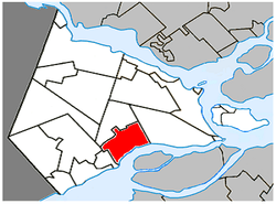 Location within Vaudreuil-Soulanges RCM | |
 Coteau-du-Lac Location in southern Quebec | |
| Coordinates: 45°18′N 74°11′W / 45.3°N 74.18°WCoordinates: 45°18′N 74°11′W / 45.3°N 74.18°W[1] | |
| Country |
|
| Province |
|
| Region | Montérégie |
| RCM | Vaudreuil-Soulanges |
| Constituted | 6 February 1982 |
| Government[2][3] | |
| • Mayor | Andrée Brosseau |
| • Federal riding | Salaberry—Suroît |
| • Prov. riding | Soulanges |
| Area[2][4] | |
| • Total | 57.20 km2 (22.09 sq mi) |
| • Land | 47.06 km2 (18.17 sq mi) |
| Population (2011)[4] | |
| • Total | 6,842 |
| • Density | 145.4/km2 (377/sq mi) |
| • Pop 2006-2011 |
|
| • Dwellings | 2,631 |
| Time zone | UTC−5 (EST) |
| • Summer (DST) | UTC−4 (EDT) |
| Postal code(s) | J0P |
| Area code(s) | 450 and 579 |
| Highways |
|
| Website |
www |
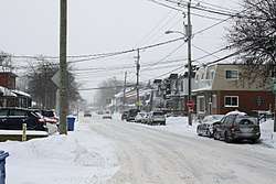
Coteau-du-Lac is a small city in southwestern Quebec, Canada. It is on the north shore of the St. Lawrence River in the Vaudreuil-Soulanges Regional County Municipality.
The name of the town comes from the French word Coteau which meant "slope" and from its location on the north shore of Lake Saint Francis.[5] The National Historic Site of Canada of the Coteau-du-Lac canal is the location of the first canal lock system in North America. The city has an industrial park.
The population was 6,842 as of the Canada 2011 Census.
Demographics
Population
| Canada census – Coteau-du-Lac, Quebec community profile | |||
|---|---|---|---|
| 2011 | 2006 | ||
| Population: | 6,842 (+7.8% from 2006) | 6,346 (+13.9% from 2001) | |
| Land area: | 47.06 km2 (18.17 sq mi) | 47.06 km2 (18.17 sq mi) | |
| Population density: | 145.4/km2 (377/sq mi) | 134.9/km2 (349/sq mi) | |
| Median age: | 39.0 (M: 39.0, F: 38.9) | 36.6 (M: 36.8, F: 36.4) | |
| Total private dwellings: | 2,631 | 2,407 | |
| Median household income: | $71,517 | $64,574 | |
| References: 2011[4] 2006[6] earlier[7] | |||
| Coteau-du-Lac, Quebec[8] | ||
|---|---|---|
| Year | Pop. | ±% |
| 1991 | 4,193 | — |
| 1996 | 4,960 | +18.3% |
| 2001 | 5,573 | +12.4% |
| 2006 | 6,346 | +13.9% |
| 2011 | 6,842 | +7.8% |
Language
| Canada Census Mother Tongue - Coteau-du-Lac, Quebec[8] | ||||||||||||||||||
|---|---|---|---|---|---|---|---|---|---|---|---|---|---|---|---|---|---|---|
| Census | Total | French |
English |
French & English |
Other | |||||||||||||
| Year | Responses | Count | Trend | Pop % | Count | Trend | Pop % | Count | Trend | Pop % | Count | Trend | Pop % | |||||
2011 |
6,720 |
6,350 | 94.49% | 240 | 3.57% | 55 | 0.82% | 75 | 1.12% | |||||||||
2006 |
6,235 |
5,960 | 95.59% | 140 | 2.25% | 45 | 0.72% | 90 | 1.44% | |||||||||
2001 |
5,455 |
5,220 | 95.69% | 170 | 3.12% | 35 | 0.64% | 30 | 0.55% | |||||||||
1996 |
4,895 |
4,695 | n/a | 95.91% | 135 | n/a | 2.76% | 35 | n/a | 0.72% | 30 | n/a | 0.61% | |||||

Town hall of Coteau-du-Lac
Education
Commission Scolaire des Trois-Lacs operates Francophone schools.[9]
- École de Coteau-du-Lac (pavillons Académie-Wilson, de l'Éclusière, and Saint-Ignace)
Lester B. Pearson School Board operates Anglophone schools.[10]
- Evergreen Elementary and Forest Hill Elementary (Junior Campus and Senior campus) in Saint-Lazare or Soulanges Elementary School in Saint-Télesphore
Notable people
- Jules Fournier (1884-1918) was a Canadian writer and newspaper owner[11]
See also
References
- ↑ Reference number 399922 of the Commission de toponymie du Québec (in French)
- 1 2 Ministère des Affaires Municipales et Regions Quebec: Coteau-du-Lac
- ↑ Parliament of Canada Federal Riding History: VAUDREUIL--SOULANGES (Quebec)
- 1 2 3 "2011 Community Profiles". Canada 2011 Census. Statistics Canada. July 5, 2013. Retrieved 2014-01-29.
- ↑ Parks Canada Website
- ↑ "2006 Community Profiles". Canada 2006 Census. Statistics Canada. March 30, 2011. Retrieved 2013-05-18.
- ↑ "2001 Community Profiles". Canada 2001 Census. Statistics Canada. February 17, 2012.
- 1 2 Statistics Canada: 1996, 2001, 2006, 2011 census
- ↑ "Les écoles et les centres". Commission Scolaire des Trois-Lacs. Retrieved 18 January 2013.
- ↑ "School Board Map." Lester B. Pearson School Board. Retrieved on September 28, 2017.
- ↑ Mailhot, Laurent (2000). "Jules Fournier". Dictionary of Canadian Biography.
External links
![]()
- Official website (in French)
Places adjacent to Coteau-du-Lac, Quebec | ||||||||||
|---|---|---|---|---|---|---|---|---|---|---|
| ||||||||||
| Cities & towns | |
|---|---|
| Municipalities | |
| Villages | |
| |
This article is issued from
Wikipedia.
The text is licensed under Creative Commons - Attribution - Sharealike.
Additional terms may apply for the media files.