Saint-Robert, Lot-et-Garonne
| Saint-Robert | ||
|---|---|---|
| Commune | ||
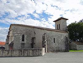 The church in Saint-Robert | ||
| ||
 Saint-Robert Location within Nouvelle-Aquitaine region  Saint-Robert | ||
| Coordinates: 44°14′52″N 0°47′45″E / 44.2478°N 0.7958°ECoordinates: 44°14′52″N 0°47′45″E / 44.2478°N 0.7958°E | ||
| Country | France | |
| Region | Nouvelle-Aquitaine | |
| Department | Lot-et-Garonne | |
| Arrondissement | Agen | |
| Canton | Le Pays de Serres | |
| Intercommunality | Roquentin | |
| Government | ||
| • Mayor (2001–2008) | Jean Dabzac | |
| Area1 | 6.74 km2 (2.60 sq mi) | |
| Population (1999)2 | 175 | |
| • Density | 26/km2 (67/sq mi) | |
| Time zone | UTC+1 (CET) | |
| • Summer (DST) | UTC+2 (CEST) | |
| INSEE/Postal code | 47273 /47340 | |
| Elevation | 82–213 m (269–699 ft) | |
|
1 French Land Register data, which excludes lakes, ponds, glaciers > 1 km2 (0.386 sq mi or 247 acres) and river estuaries. 2 Population without double counting: residents of multiple communes (e.g., students and military personnel) only counted once. | ||

Saint-Robert (Languedocien: Sant Robèrt) is a commune in the Lot-et-Garonne department in south-western France.
See also
References
| Wikimedia Commons has media related to Saint-Robert (Lot-et-Garonne). |
This article is issued from
Wikipedia.
The text is licensed under Creative Commons - Attribution - Sharealike.
Additional terms may apply for the media files.