Saint-Pastour
| Saint-Pastour | ||
|---|---|---|
| Commune | ||
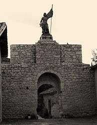 A statue of Joan of Arc, in Saint-Pastour | ||
| ||
 Saint-Pastour Location within Nouvelle-Aquitaine region  Saint-Pastour | ||
| Coordinates: 44°29′21″N 0°36′03″E / 44.4892°N 0.6008°ECoordinates: 44°29′21″N 0°36′03″E / 44.4892°N 0.6008°E | ||
| Country | France | |
| Region | Nouvelle-Aquitaine | |
| Department | Lot-et-Garonne | |
| Arrondissement | Villeneuve-sur-Lot | |
| Canton | Le Livradais | |
| Intercommunality | Lot et Tolzac | |
| Government | ||
| • Mayor (2001–2008) | Jean Cosserant | |
| Area1 | 14.52 km2 (5.61 sq mi) | |
| Population (1999)2 | 361 | |
| • Density | 25/km2 (64/sq mi) | |
| Time zone | UTC+1 (CET) | |
| • Summer (DST) | UTC+2 (CEST) | |
| INSEE/Postal code | 47265 /47290 | |
| Elevation |
62–196 m (203–643 ft) (avg. 185 m or 607 ft) | |
|
1 French Land Register data, which excludes lakes, ponds, glaciers > 1 km2 (0.386 sq mi or 247 acres) and river estuaries. 2 Population without double counting: residents of multiple communes (e.g., students and military personnel) only counted once. | ||

Saint-Pastour is a commune in the Lot-et-Garonne department in south-western France.
See also
References
| Wikimedia Commons has media related to Saint-Pastour. |
This article is issued from
Wikipedia.
The text is licensed under Creative Commons - Attribution - Sharealike.
Additional terms may apply for the media files.