Pompogne
| Pompogne | |
|---|---|
| Commune | |
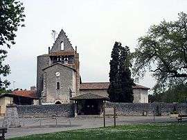 The church in Pompogne | |
 Pompogne Location within Nouvelle-Aquitaine region  Pompogne | |
| Coordinates: 44°15′24″N 0°03′09″E / 44.2567°N 0.0525°ECoordinates: 44°15′24″N 0°03′09″E / 44.2567°N 0.0525°E | |
| Country | France |
| Region | Nouvelle-Aquitaine |
| Department | Lot-et-Garonne |
| Arrondissement | Nérac |
| Canton | Les Forêts de Gascogne |
| Intercommunality | Communauté de communes des Coteaux et des Landes de Gascogne |
| Government | |
| • Mayor (2001–2008) | Jean-Pierre Jolis |
| Area1 | 35.96 km2 (13.88 sq mi) |
| Population (1999)2 | 138 |
| • Density | 3.8/km2 (9.9/sq mi) |
| Time zone | UTC+1 (CET) |
| • Summer (DST) | UTC+2 (CEST) |
| INSEE/Postal code | 47208 /47420 |
| Elevation |
77–147 m (253–482 ft) (avg. 96 m or 315 ft) |
|
1 French Land Register data, which excludes lakes, ponds, glaciers > 1 km2 (0.386 sq mi or 247 acres) and river estuaries. 2 Population without double counting: residents of multiple communes (e.g., students and military personnel) only counted once. | |
Pompogne is a commune in the Lot-et-Garonne department in south-western France.
Demography
| Year | 1962 | 1968 | 1975 | 1982 | 1990 | 1999 | 2006 |
|---|---|---|---|---|---|---|---|
| Population | 144 | 127 | 104 | 105 | 124 | 138 | 148 |
| From the year 1962 on: No double counting—residents of multiple communes (e.g. students and military personnel) are counted only once. | |||||||
See also
References
- ↑ Le Mas-d'Agenais sur le site de l'Insee Archived 2012-11-09 at the Wayback Machine.
| Wikimedia Commons has media related to Pompogne. |
This article is issued from
Wikipedia.
The text is licensed under Creative Commons - Attribution - Sharealike.
Additional terms may apply for the media files.