Lacapelle-Biron
| Lacapelle-Biron | ||
|---|---|---|
| Commune | ||
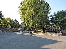 The main square in Lacapelle-Biron | ||
| ||
 Lacapelle-Biron Location within Nouvelle-Aquitaine region  Lacapelle-Biron | ||
| Coordinates: 44°36′04″N 0°53′48″E / 44.6011°N 0.8967°ECoordinates: 44°36′04″N 0°53′48″E / 44.6011°N 0.8967°E | ||
| Country | France | |
| Region | Nouvelle-Aquitaine | |
| Department | Lot-et-Garonne | |
| Arrondissement | Villeneuve-sur-Lot | |
| Canton | Le Fumélois | |
| Intercommunality | Communauté de communes Bastide et Châteaux en Guyenne | |
| Government | ||
| • Mayor (2008–2014) | Christian Saint-Béat | |
| Area1 | 13.96 km2 (5.39 sq mi) | |
| Population (1999)2 | 429 | |
| • Density | 31/km2 (80/sq mi) | |
| Time zone | UTC+1 (CET) | |
| • Summer (DST) | UTC+2 (CEST) | |
| INSEE/Postal code | 47123 /47150 | |
| Elevation |
145–243 m (476–797 ft) (avg. 150 m or 490 ft) | |
|
1 French Land Register data, which excludes lakes, ponds, glaciers > 1 km2 (0.386 sq mi or 247 acres) and river estuaries. 2 Population without double counting: residents of multiple communes (e.g., students and military personnel) only counted once. | ||
.svg.png)
Lacapelle-Biron is a commune in the Lot-et-Garonne department in south-western France.
See also
| Wikimedia Commons has media related to Lacapelle-Biron. |
This article is issued from
Wikipedia.
The text is licensed under Creative Commons - Attribution - Sharealike.
Additional terms may apply for the media files.