La Sauvetat-du-Dropt
| La Sauvetat-du-Dropt | ||
|---|---|---|
| Commune | ||
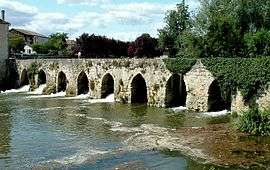 The old bridge in La Sauvetat-du-Dropt | ||
| ||
 La Sauvetat-du-Dropt Location within Nouvelle-Aquitaine region  La Sauvetat-du-Dropt | ||
| Coordinates: 44°38′53″N 0°20′23″E / 44.6481°N 0.3397°ECoordinates: 44°38′53″N 0°20′23″E / 44.6481°N 0.3397°E | ||
| Country | France | |
| Region | Nouvelle-Aquitaine | |
| Department | Lot-et-Garonne | |
| Arrondissement | Marmande | |
| Canton | Les Coteaux de Guyenne | |
| Intercommunality | Communauté de communes du Pays de Lauzun | |
| Government | ||
| • Mayor (2008–2014) | Jean-Luc Gardeau | |
| Area1 | 10.37 km2 (4.00 sq mi) | |
| Population (2006)2 | 555 | |
| • Density | 54/km2 (140/sq mi) | |
| Time zone | UTC+1 (CET) | |
| • Summer (DST) | UTC+2 (CEST) | |
| INSEE/Postal code | 47290 /47800 | |
| Elevation | 36–123 m (118–404 ft) | |
|
1 French Land Register data, which excludes lakes, ponds, glaciers > 1 km2 (0.386 sq mi or 247 acres) and river estuaries. 2 Population without double counting: residents of multiple communes (e.g., students and military personnel) only counted once. | ||

La Sauvetat-du-Dropt is a commune in the Lot-et-Garonne department in south-western France.
See also
| Wikimedia Commons has media related to La Sauvetat-du-Dropt. |
This article is issued from
Wikipedia.
The text is licensed under Creative Commons - Attribution - Sharealike.
Additional terms may apply for the media files.