Gavaudun
| Gavaudun | |
|---|---|
| Commune | |
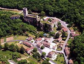 A general view of Gavaudun | |
 Gavaudun Location within Nouvelle-Aquitaine region  Gavaudun | |
| Coordinates: 44°33′41″N 0°53′18″E / 44.5614°N 0.8883°ECoordinates: 44°33′41″N 0°53′18″E / 44.5614°N 0.8883°E | |
| Country | France |
| Region | Nouvelle-Aquitaine |
| Department | Lot-et-Garonne |
| Arrondissement | Villeneuve-sur-Lot |
| Canton | Le Haut agenais Périgord |
| Intercommunality | Communauté de communes Bastide et Châteaux en Guyenne |
| Government | |
| • Mayor (2008–2014) | Eric Congé |
| Area1 | 21.33 km2 (8.24 sq mi) |
| Population (2006)2 | 286 |
| • Density | 13/km2 (35/sq mi) |
| Time zone | UTC+1 (CET) |
| • Summer (DST) | UTC+2 (CEST) |
| INSEE/Postal code | 47109 /47150 |
| Elevation |
105–243 m (344–797 ft) (avg. 111 m or 364 ft) |
|
1 French Land Register data, which excludes lakes, ponds, glaciers > 1 km2 (0.386 sq mi or 247 acres) and river estuaries. 2 Population without double counting: residents of multiple communes (e.g., students and military personnel) only counted once. | |
Gavaudun is a commune in the Lot-et-Garonne department in south-western France.

See also
| Wikimedia Commons has media related to Gavaudun. |
This article is issued from
Wikipedia.
The text is licensed under Creative Commons - Attribution - Sharealike.
Additional terms may apply for the media files.